1856 Map... What does SM mean?

IMAUDIGGER

Silver Member
Mar 16, 2016
3,400
5,194
Primary Interest:
All Treasure Hunting
Iā€™d guess in your instance, itā€™s likely referring to ā€œBench Markā€ the numbers either being the elevation, or the name of the survey monument.

B636AF00-D977-45F9-B609-FA6E0574B089.jpeg

In this case itā€™s a triangulation survey marker located at the top of a mountain.
 

Last edited:

franklin

Gold Member
Jun 1, 2012
5,036
7,168
Detector(s) used
Garrett ADS-7X, Fisher Two Box M-Scope, Mother Lode Locator, Dowsing Model 20 Electroscope, White's TM808, White's TM900, Inground Scanners
Primary Interest:
All Treasure Hunting
BM stands for Boundary Marker. SM stands for Survey Marker.
 

Last edited:

IMAUDIGGER

Silver Member
Mar 16, 2016
3,400
5,194
Primary Interest:
All Treasure Hunting
Iā€™d have to respectfully disagree.
When any of the following have a third order or better elevation assigned AND are monumented with a tablet, they are labeled as ā€œBMā€ (bench mark);

1.) Boundary monuments (square with dot)
2.) Horizontal control (triangle)
3.) Vertical control ( x )

Itā€™s the vertical elevation aspect that triggers the annotation.
Boundary monuments donā€™t typically have elevations assigned, nor are they usually numbered.

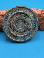
Here is what you will typically find at one of those locations labeled ā€œBMā€...at least thatā€™s been my experience. Note ā€œB.M.ā€ embossed on the first tablet.

C2CB3892-86B9-4AAE-A472-D6794643237C.jpeg

1ABAD5A9-0652-4240-AE71-6DC84EDBB8C4.jpeg
 

Last edited:

teleprospector

Silver Member
Jul 8, 2007
3,794
4,134
The Motor City
šŸ† Honorable Mentions:
25
Detector(s) used
Extended Sensory Perception, L-rod, Y-rod, pendulum, angle rods, wand.
White's MXT, Garrett Ultra GTA 500, AT Gold, SCUBA Detector Pro Headhunter, Tesoro Sidewinder, Stingray, 2 box-TF900, Fisher TW-6
Primary Interest:
All Treasure Hunting
Iā€™d guess in your instance, itā€™s likely referring to ā€œBench Markā€ the numbers either being the elevation, or the name of the survey monument.

View attachment 1880139

In this case itā€™s a triangulation survey marker located at the top of a mountain.
Looks like the 5684 is the elevation since the contour lines downslope show 5000 and 4500.
Jon 8-) :cat: :occasion14: :headbang:
 

Gare

Gold Member
Dec 30, 2012
7,482
14,061
Canton Ohio Area
šŸ† Honorable Mentions:
2
Detector(s) used
Presently using Deus 2's & have Minelabs, Nokta's Tesoro's DEus's Have them all . Have WAY to many need to get rid of some
Primary Interest:
All Treasure Hunting
What about Gold Mine and Silver Mine ?
 

Top Member Reactions

Users who are viewing this thread

Top