You are using an out of date browser. It may not display this or other websites correctly.
You should upgrade or use an alternative browser.
You should upgrade or use an alternative browser.
200 pounds of High Grade Sylvanite Gold Ore
- Thread starter Barton
- Start date


Barton
Sr. Member
- Joined
- Apr 21, 2005
- Messages
- 449
- Reaction score
- 322
- Golden Thread
- 0
- Location
- Abiquiu, NM
- Detector(s) used
- What ever is needed for the project I am working on--I am a cache hunter
- Primary Interest:
- Cache Hunting
- #22
Thread Owner
Hello morbiusandneo,
My daughter took my to the Black Canyon of the Gunnison--it was there we saw the Gorilla. I would have to ask her
if she recalls where she took me. I know the elevation was not high.
The location of the Dragons varies from about 10,000 feet elevation and then higher. I did have numerous photos of dragons but my computer
started crashing so it went in for repairs--the repair man has not been returning my calls--other that to say he traveled else where for health
reasons. I probably have a paper photo of several Dragons and possibly a King feeding Dragons if you care to come by for a visit--
In which case I will dig out a photo. Even this computer I am typing on is on its last legs crashing 1-2 times a day.
bartonthom@yahoo.com Barton
HardHatMatt
Full Member
.webp")
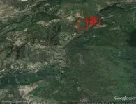
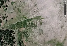
Greetings - able to pick up anything on this map? Related to Barton's original query, but about 40 miles southeast. Thanks in advance!
PatrickD
Hero Member
To the best of my understanding--the Spanish had many mines / placer mining --operations in the San Juan Mountains.
I believe the French were also here mining gold and silver.
My theory is that for a prospector today to make a gold or silver strike in the US--your best chance for a recovery
would be exploring / prospecting in the San Juan Mountains. I think that there are both lode and placer deposits yet
to be discovered as well as rich mineral deposits Worked by the Spanish as well as groups that came long before the
Spanish. Once when I was up in the San Juan Mountains I saw a number of Dragons from 30' to 200 ' tall. Could
they have been made by the Chinese centuries earlier? I have also seen Gorillas 300 feet tall--at the Black Canyon
of the Gunnison--and the Gorilla was wearing a belt and had a purse on his belt. I have no idea who made the Gorilla
but my hunch is it was here before the Pilgrims' landed at Plymouth Rock and even before Cortez reached Mexico City.
I would include the Sangre de Christos in that as well.
Red_desert
Gold Member
- Joined
- Feb 21, 2008
- Messages
- 7,158
- Reaction score
- 3,794
- Golden Thread
- 0
- Location
- Midwest USA
- Detector(s) used
- Garrett Ace 250/GTA 1,000; Fisher Gold Bug-2; Gemini-3; Unique Design L-Rods
- Primary Interest:
- All Treasure Hunting
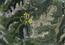
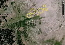
Barton sent me coordinates I think were south of the original gps. Anyway, if it was S of there, I marked only 1 yellow circle for shallow native gold, all the others for deeper or veins. I zoomed in to the circle area to make maps and then never checked them because Barton thought the yellow circle is the same location as Art found. I didn't check for any man made gold objects, only for shallow or deeper native gold. This location was east of the coordinates, probably on the bottom fringe of the map I'd already posted in the thread here. If you want me to, I'll check to see if the yellow circle is SE of Barton's original coordinates.View attachment 1359237
Greetings - able to pick up anything on this map? Related to Barton's original query, but about 40 miles southeast. Thanks in advance!
Last edited:
Barton
Sr. Member
- Joined
- Apr 21, 2005
- Messages
- 449
- Reaction score
- 322
- Golden Thread
- 0
- Location
- Abiquiu, NM
- Detector(s) used
- What ever is needed for the project I am working on--I am a cache hunter
- Primary Interest:
- Cache Hunting
- #26
Thread Owner
Hard Hat Matt's aerial photo is about 40 miles from the Rio Grande Pyramid ( Ute Creek)---he believes that there is a possibility that
the Spanards / Frenchmen who were mining up upon Ute Creek may have placed some caches here ( that is why he says it is related to my site ).
If my memory serves me correctly this ( aerial photo ) looks like the head waters of the Piedra River.
Barton
the Spanards / Frenchmen who were mining up upon Ute Creek may have placed some caches here ( that is why he says it is related to my site ).
If my memory serves me correctly this ( aerial photo ) looks like the head waters of the Piedra River.
Barton
Barton
Sr. Member
- Joined
- Apr 21, 2005
- Messages
- 449
- Reaction score
- 322
- Golden Thread
- 0
- Location
- Abiquiu, NM
- Detector(s) used
- What ever is needed for the project I am working on--I am a cache hunter
- Primary Interest:
- Cache Hunting
- #27
Thread Owner
Hello Red Desert,
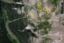
If you are looking at your post #10 ( it has in Red #1, #2, #3 ) it shows an excellent view of UTE CREEK--the Middle Fork, the West Fork and the East Fork.
The GPS cordinates I gave were of the upper portion of the Middle Fork of Ute Creek where a cache of high grade ore was found. Your yellow circle was in this
photo #10 post in the East fork of Ute Creek. A little to the NE of where the cache was recovered.
It is my personal belief that there may be Spanish / French mines AND ore caches on the West, Middle and East branch's / forks of Ute Creek. My personal
belief is there was a lot more mining of gold and silver that is generally believed. When the Spanish were mining in the New World they were actually filling
up a Treasure Fleet of ships every year for shipment back to Spain. In just about every western state of the US and Mexico there are stories from the old days of
early Spanish mining. If one were to see or handle one of these old bars of Spanish gold or silver then you might have a unshakable belief that mining did in fact occur.
Many people go prospecting up on Ute Creek looking for the Spanish mine old stories speak of. My view is there was NOT one single mine--but several.
HardHatMatt--seems to have an interest in a cache site to the SE.
Barton
PatrickD
Hero Member
Hi Barton,
I seem to recall a couple letters between my father and KvM about Pyramid Mountain and Spanish gold caches. The letters are boxed up but I will try to dig around and find the relevant ones.
I know there was a tiny plastic square (like clear plastic that would have been used with an overhead projector back in the day.) It had a representation of Pyramid mountain and I seem to recall they believed Pyramid mountain was the pyramid on the LUE map. So, in their discussions, it would have tied to Spanish mining and caching sites.
Not sure if this helps.
Good luck, I hope you find a ton of gold bars.
Patrick
Barton
Sr. Member
- Joined
- Apr 21, 2005
- Messages
- 449
- Reaction score
- 322
- Golden Thread
- 0
- Location
- Abiquiu, NM
- Detector(s) used
- What ever is needed for the project I am working on--I am a cache hunter
- Primary Interest:
- Cache Hunting
- #29
Thread Owner
I would love to see any letters written by KVM as he was very perceptive and an excellent treasure hunter
Barton
Barton
PatrickD
Hero Member
I would love to see any letters written by KVM as he was very perceptive and an excellent treasure hunter
Barton
Some of the content has to be filtered. He was very opinionated and a lot of his comments sound like they could have come from Archie Bunker. I suppose that was the time period they were written in.
Red_desert
Gold Member
- Joined
- Feb 21, 2008
- Messages
- 7,158
- Reaction score
- 3,794
- Golden Thread
- 0
- Location
- Midwest USA
- Detector(s) used
- Garrett Ace 250/GTA 1,000; Fisher Gold Bug-2; Gemini-3; Unique Design L-Rods
- Primary Interest:
- All Treasure Hunting
Yes, I found out checking, that the coordinates were up a ways from the 1st gps point you gave. My original red boxes were mostly up there anyway.Hello Red Desert,
If you are looking at your post #10 ( it has in Red #1, #2, #3 ) it shows an excellent view of UTE CREEK--the Middle Fork, the West Fork and the East Fork.
The GPS cordinates I gave were of the upper portion of the Middle Fork of Ute Creek where a cache of high grade ore was found. Your yellow circle was in this
photo #10 post in the East fork of Ute Creek. A little to the NE of where the cache was recovered.
It is my personal belief that there may be Spanish / French mines AND ore caches on the West, Middle and East branch's / forks of Ute Creek. My personal
belief is there was a lot more mining of gold and silver that is generally believed. When the Spanish were mining in the New World they were actually filling
up a Treasure Fleet of ships every year for shipment back to Spain. In just about every western state of the US and Mexico there are stories from the old days of
early Spanish mining. If one were to see or handle one of these old bars of Spanish gold or silver then you might have a unshakable belief that mining did in fact occur.
Many people go prospecting up on Ute Creek looking for the Spanish mine old stories speak of. My view is there was NOT one single mine--but several.
HardHatMatt--seems to have an interest in a cache site to the SE.
Barton
HardHatMatt
Full Member
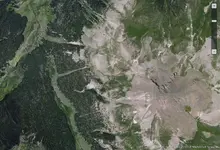
My aerial photo is of the Upper Blanco River, south of Pagosa Springs. A deteriorated packsaddle filled with gold bars (and the skeleton of the mule carrying them) was found in this area in the mind 1900s...it is believed that this discovery may be related to the mine and cache(s) about which Barton has inquired. Apparently there was more than one mule lost in the Upper Blanco Basin on that occasion.
Red_desert
Gold Member
- Joined
- Feb 21, 2008
- Messages
- 7,158
- Reaction score
- 3,794
- Golden Thread
- 0
- Location
- Midwest USA
- Detector(s) used
- Garrett Ace 250/GTA 1,000; Fisher Gold Bug-2; Gemini-3; Unique Design L-Rods
- Primary Interest:
- All Treasure Hunting
Here is an area, you might want to check out.My aerial photo is of the Upper Blanco River, south of Pagosa Springs. A deteriorated packsaddle filled with gold bars (and the skeleton of the mule carrying them) was found in this area in the mind 1900s...it is believed that this discovery may be related to the mine and cache(s) about which Barton has inquired. Apparently there was more than one mule lost in the Upper Blanco Basin on that occasion.
Attachments
HardHatMatt
Full Member
Very much appreciated.
Red_desert
Gold Member
- Joined
- Feb 21, 2008
- Messages
- 7,158
- Reaction score
- 3,794
- Golden Thread
- 0
- Location
- Midwest USA
- Detector(s) used
- Garrett Ace 250/GTA 1,000; Fisher Gold Bug-2; Gemini-3; Unique Design L-Rods
- Primary Interest:
- All Treasure Hunting
Red_desert
Gold Member
- Joined
- Feb 21, 2008
- Messages
- 7,158
- Reaction score
- 3,794
- Golden Thread
- 0
- Location
- Midwest USA
- Detector(s) used
- Garrett Ace 250/GTA 1,000; Fisher Gold Bug-2; Gemini-3; Unique Design L-Rods
- Primary Interest:
- All Treasure Hunting
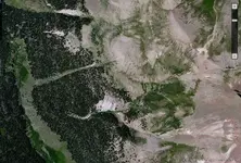
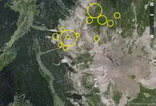
These maps are zoomed in the yellow outline circle area, with gps cropped off. I'm thinking you said this is the same as where Art found. So, I will mark the maps with gsp to send rather than post them here.
Attachments
Last edited:
Red_desert
Gold Member
- Joined
- Feb 21, 2008
- Messages
- 7,158
- Reaction score
- 3,794
- Golden Thread
- 0
- Location
- Midwest USA
- Detector(s) used
- Garrett Ace 250/GTA 1,000; Fisher Gold Bug-2; Gemini-3; Unique Design L-Rods
- Primary Interest:
- All Treasure Hunting
I forgot to make a copy of the 3rd map, which is zoomed in the most......so gps on that one was lost.
Red_desert
Gold Member
- Joined
- Feb 21, 2008
- Messages
- 7,158
- Reaction score
- 3,794
- Golden Thread
- 0
- Location
- Midwest USA
- Detector(s) used
- Garrett Ace 250/GTA 1,000; Fisher Gold Bug-2; Gemini-3; Unique Design L-Rods
- Primary Interest:
- All Treasure Hunting
Red_desert
Gold Member
- Joined
- Feb 21, 2008
- Messages
- 7,158
- Reaction score
- 3,794
- Golden Thread
- 0
- Location
- Midwest USA
- Detector(s) used
- Garrett Ace 250/GTA 1,000; Fisher Gold Bug-2; Gemini-3; Unique Design L-Rods
- Primary Interest:
- All Treasure Hunting
Red_desert
Gold Member
- Joined
- Feb 21, 2008
- Messages
- 7,158
- Reaction score
- 3,794
- Golden Thread
- 0
- Location
- Midwest USA
- Detector(s) used
- Garrett Ace 250/GTA 1,000; Fisher Gold Bug-2; Gemini-3; Unique Design L-Rods
- Primary Interest:
- All Treasure Hunting
I have some good news for WIN 10 users having Google Earth problems. When starting my computer, it took probably over an hour, updating and configuring. Looked at the start menu and display was different showing icons for desktop programs. Saw Google Earth, then looked on desktop to check icons, sure enough it is back. Opened Google Earth and all my folders with pins were there....they have fixed the problems of WIN 10 running it. 
Top Member Reactions
-
 2244
2244 -
 1519
1519 -
 1378
1378 -
 1282
1282 -
 1141
1141 -
 1041
1041 -
 958
958 -
 782
782 -
 758
758 -
 610
610 -
 571
571 -
 552
552 -
 512
512 -
 506
506 -
 479
479
Similar threads
- Replies
- 27
- Views
- 2K
- Replies
- 41
- Views
- 3K
Users who are viewing this thread
Total: 1 (members: 0, guests: 1)
