What's new

Ancient Ball Field ?

jeff of pa

Super Moderator
⛭ Moderator
🥇 Charter Member
Joined
Dec 19, 2003
Messages
96,813
Reaction score
76,246
Golden Thread
2
🥇 Banner finds
1
Primary Interest:
All Treasure Hunting
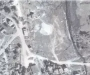
Curve Cut Through to put a Road In ?

Yes , No, Maybe ?

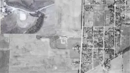
1939 Pic

!!!_1939.webp


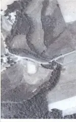
1978 Pic

!!!_1978.webp

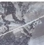
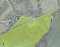
unknown date

!!!_PRESENT.webp

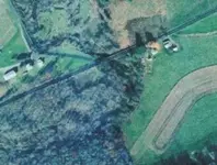
Property as it is today

!!!_PROPERTY.webp
 
I'll need the exact coordinates and a couple of days before I give my opinion on this one. ;D
 
Believe it or not since about 2000 I Have driven this road
Hundreds of Times & looked at the spot to
the South of the road.

& Always Wonderd about it.

This is the first time I Looked
at Penn Pilot in that area

hopefully it isn't too grown up.
I can't remember.

The south side is a County Park I Already have Permission for.

the North side is Borough Property & only problem I see is The farm
there probably takes care of it
because it's 3 Mile outside
the Borough. so I Would need to ask the people There.
 
Used those '39 aerials to locate some old tracks and ballfields hereabouts too, Jeff.
But your shot is lacking in detail although the physical dimensions look almost right. There's no defined infield, as in a shot of the same time from my town. How close was this to a medium-sized town, or school?

The ground scarring at the bottom of the pic, straight down from a line between what could be 1st and 2nd base, may be the dump site. Locate that first, it's near the creek so there should be picnic items, beer and soda bottles aplenty if this was a ballfield. If it's more mundane houseware and agricultural remnants then my guess is the pic is coincidental to the time of year when the shot was taken and the field has been discolored by the farming/erosion habits of the time.
 

Attachments

  • ball diamondelgin.webp
    ball diamondelgin.webp
    13 KB · Views: 401
Straight portion of new road way appears to have been built directly through the old ball field site and most certainly would have had heavy bulldozer work along with fill dirt added. :-\
 
I'm 50/50 0n it being a ball field also

There was a Girl Scout Camp within a mile of the site.
A swimming area also

The creek Flows into a Large Dam just out of
the Picture.

The area May be swamp at times
sits Down from the road on the south side.
The North plot is about Level with
the road if Memory Serves.

As I said I have Yearned to search that area every time
I Looked at it but something turned me off.

High weeds ? Swampy looking ? no Parking area ?
I Don't remember on that.

If it is a ball Field I Believe Home plate
is to the North point of
the Diamond.

Supposed to hit Upper 40's today,
I May take a run this after
with my Camera.

To Comparem These 2 are Ball fields from
1938
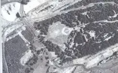
!!!!BF1.webp!!!!BF_2.webp
 
Find the/any associated dump site and you will know!
 
looks more like a hayfield to me. the rounded corners are where the tractor made it turn. and the northern tip the entrance. Sorry to be the naysayer but that's what it looks like to me
 
CWnut said:
looks more like a hayfield to me. the rounded corners are where the tractor made it turn. and the northern tip the entrance. Sorry to be the naysayer but that's what it looks like to me

I Appreciate all Positions.
This is why I Asked.

If I Knew for sure I wouldn't have Posted.

My Problem is There is not much there
to Pass for Out Buildings.

Most Ballfields at Least have a Concession stand
and benches.

and although the Pics are poor,
I still believe something would Show

Of Course The Ancient (Original)
Make do
Ball fields were farmers Fields
 
Re: Ancient Ball Field ? Just back from looking

Couldn't get Pictures.
Rectangular area in the Newer Pics is Tall DRY Grass
that has been Driven down By Vehicles.
They are parked there to Fish in the creek
They had it parked Full.

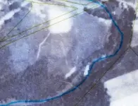
Here is the Best I Can do on a Layover of the old Areal

!!!LYOVER.webp


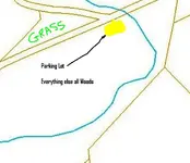
Area North of the Road is a good Drop from the road &
Mowed Grass

Area South of the Road, also drops down a Good Distance
and with the Exception
of the Parking area is all open Woods.

!!!!schuylkill_outside_gis-apps30163164177461.webp

Will Be worth the Try when spring gets here.

An accumulation of wet Snow Expected tuesday night
into Wednsday :(
 
well, "something" was there to make the road go around. Maybe a UFO was sitting there.
 
Jeff.....Looks like you're spending PLENTY of time on PennPilots as well! <grin!>

I have also found some old ballfields (no question about it) and they HAVEN'T been paved over (all trees now).

I'm having a HECK of a time trying to crop out snippets of those huge photo's and posting them to the thread witha modern day look at the same area with Google Maps.

I'll try from home this evening.
 
Gary in Pennsylvania said:
Jeff.....Looks like you're spending PLENTY of time on PennPilots as well! <grin!>

I have also found some old ballfields (no question about it) and they HAVEN'T been paved over (all trees now).

I'm having a HECK of a time trying to crop out snippets of those huge photo's and posting them to the thread witha modern day look at the same area with Google Maps.

I'll try from home this evening.

I Havn't figured out how To save the Pics In my Photos yet.


I Have to Crop it down Then Print out a copy
Then Scan the Picture to save it.

IF Anyone knows a shortcut I Would appreciate
Click for Click Details.

The only one I can save in My Pictures is the
Sample above with the Plus Mark beside it.
Which Blurs at Close Range.
 
jeff of pa said:
IF Anyone knows a shortcut I Would appreciate
Click for Click Details.

The only one I can save in My Pictures is the
Sample above with the Plus Mark beside it.
Which Blurs at Close Range.


Ahhhhhh.....I can do it at home on my MAC....but not here at work (plus, my employer has many of the standard Windows functions disabled).

I'd like to share a research mystery with the TN crew. It's messing with my mind that I can find no land feature evidence of an abandoned airfield in my area. It was active from 1928-ish to 1855-ish and even had a Army Air presence during WWII. I have a very detailed WRITTEN history (confirmed by my county's Historical Society). But I have NO PICS!
Then came the PennPilot's link. I figured 1939 (date of the aerials) was DEAD in the middle of airfield activity.....but there's NUTHIN'! No telltale signs at ALL!

I don't want to hijack this thread - I'll be posting a 'help wanted' thread of my own soon.
 
That is strange there should at least be long straight tracks

& Possably Hangers
 
There's only one way to find out if its a ball field and if there's anything there to find...

Why are you wasting your time when you could be hitting the dirt?
 
stefen said:
There's only one way to find out if its a ball field and if there's anything there to find...

Why are you wasting your time when you could be hitting the dirt?

the Weather Got me Stranded ;D

Possably a friday Project
 
;D

Guess I'll Rub it in ;D

Supposed to be 60 - 64 Tomorrow & Will Hopefully get out
Tomorrow also.

But been Promising to Hit a spot DKinPA has been
working to see IF I can find some things he's been missing.

he has to work too :tongue3:

Hi Ho Hi Ho :wink:
 

Users who are viewing this thread

Latest Discussions

Back
Top Bottom