Idahodutch
Bronze Member
Here is a GE image of a different old road coming out of Portland.
The end of the line is a park now. Approx 2.2 miles

The end of the line is a park now. Approx 2.2 miles
The name of the park, is Creston Park, and the road’s name is Powell Blvd.Here is a GE image of a different old road coming out of Portland.
The end of the line is a park now. Approx 2.2 miles
View attachment 2106843
That's one of the problems with old time information - the distances are very seldom precise, and sometimes not even close. I've seen several descriptions of a local place that I know precisely where it is, and the old descriptions vary from "2 miles" to "5 miles" from town -- and "town" isn't nearly big enough to absorb that much variation.I looked at it from the river edge, but in reality, it was probably not an exact measurement of 2 miles, but a rough estimate, and was to be from edge of town.
Good job Crow,
Crow, I believe the pioneer church ( depicted on the chart ) was moved in 1948 to its original place as a historical monument. After your intelligent research, we came to the same starting point from my theory. It's good when historical facts coincide with research results.Here is a picture below in its original position of the church taken in 1947 one year before it was moved to its present location in 1948. Middle left hand side on the street corner.
View attachment 2107650
Below The church in 1870 center of picture next to the flower mill. taken from across the river.
View attachment 2107651
That would of been some 8 years after the alleged burial of the the allege money.
Crow
Crow,Some good points.
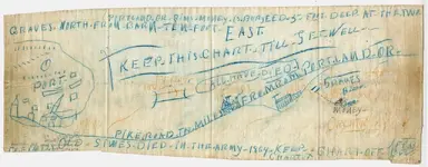
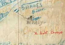
We have have key landmarks. A house, a barn, two graves?
There is one other key detail? The church in the map perhaps? Does the church has any significance as landmark to take the rough 2 miles from?
I did find a church that was built Well before the Civil war Its Portlands Oldest Church.
Oaks Pioneer Church, formerly known as St. John's Episcopal Church, in southeast Portland in the U.S. state of Oregon is a non-denominational one-story chapel listed on the National Register of Historic Places. Built in 1851, it was added to the register in 1974. It is the oldest intact church building in Oregon.
View attachment 2107614
Located in Oaks Pioneer Park in the Sellwood neighborhood, the rectangular post and beam structure has a footprint of 18 by 42 feet (5.5 by 12.8 m). Fashioned from a partly completed house owned by pioneer Lot Whitcomb, it was the first Episcopal Church in Oregon.
Lot Whitcomb (1807–1857) was an American commercial entrepreneur and politician who established the city of Milwaukie Oregon After making a fortune milling and shipping lumber and timber for California gold miners, Whitcomb launched the first steamship in the U.S. state of Oregon Here is a picture Lot Whitcomb below.
View attachment 2107619
Whitcomb was a steamboat operator who founded the community of Milwaukie, The church, originally sited on the outskirts of Milwaukie, was moved nearer the town's center in 1862. Modifications over the years included revisions to the Chancel in 1869 and the windows, siding, and belfry in 1888. The belfry contains a ship's bell that belonged to Whitcomb.
Supplanted by a new church building in 1948 (St. John the Evangelist Episcopal Church in Milwaukie, Oregon) and scheduled for demolition in 1969, the church was saved by private interests that paid to float it down the Willamette River on a barge and install it in Oaks Pioneer Park.
View attachment 2107615
Is this church above the church of crude rendition below?
View attachment 2107618
Where The Church is today had no relevance to the map but where it was sited in 1862 does. It gives is an anchor point to work from?
Here is picture of the present church built in 1948 on site.
View attachment 2107620
Is this the key point to work from.
Perhaps pike road evolved for the saw milling site and port at the time? This measurement has to be taken from this site. Portland name was given perhaps being the bigger city was just easier to find than Milwaukie?
Originally the port and grist mill was behind the church on the river. The port does not exist today as it was supplanted by the Portland down the river.
1 PIKES
2 PORT OF Milwaukie SAW MILL AND GRIST MILL
3 CHURCH SITE IN 1862.
View attachment 2107625
+ Note it does not say on this part of map Portland just port? The alleged pike road was perhaps a description of pikes used to role loges over at the river of port? And thus PERHAPS the rough dirt road at the time was unofficially known as the pike road?
That said this is speculation just as everyone else? Millwakie is about 5 miles from Center of Portland.
Here is more information about Millwakie.
Although the plan showed orderly blocks surrounding a public square, the reality of Milwaukie in 1848 was somewhat different. According to local historian Charles Oluf Olsen, early Milwaukie was a generally unpleasant place:
“Houses and shacks were of raw lumber, unpainted and crude. Streets were narrow, muddy and full of stumps, with miry puddles in which hogs wallowed. Cattle roamed at large. But there was virile life in the primitive settlement, and its position as the future metropolis of the Oregon Country seemed assured.”
By the fall of 1850 Milwaukie had 500 residents, two hotels, a post office, a sheet iron and copper plate works, a shoe store, several general stores, several saloons, four mills, a waterfront warehouse and wharf, and a school. A free public ferry and Episcopal church followed a year later. The city even had its own newspaper, the Western Star, for a brief time in 1850.
Lot Whitcomb built and launched the steamer “Lot Whitcomb” in 1850. His intention was to protect Milwaukie’s growth and damage Portland’s by providing shipping services to Milwaukie while ignoring Portland, which had become a rival. Due in large part to the success of the “Lot Whitcomb,” Milwaukie became a Port of Delivery by Congressional Appointment in April, 1851, and a shipbuilding industry sprang up.
By 1851 Portland had edged ahead of Milwaukie in the shipping business, and the “Lot Whitcomb” was sold to buyers in California in 1854. Although Milwaukie was no longer dominant in shipping, it quickly became the center of fruit production in the region. The Llewelling brothers, Seth and Henderson, carried nursery stock from their homes in Iowa and planted their first nursery on the present site of the golf course at the Waverly Country Club.
Is this a clue? Llewelling brothers, Seth and Henderson had a fruit orchard? Here is picture of his property Below. He owned orchards
View attachment 2107639
View attachment 2107640
Any one of theorize that has been posted here has very good points. But fun all the same to speculate.
Crow