wonder if the probate records are still accessible from the time he was a Judge in Seattle
from the article @ Atlas Obscura
The map had been discovered a few years earlier after the death of a Seattle judge named Everett Smith.
His son, Irving, had found it among his father’s papers. At the time, Irving told the Oregon Historical
Quarterly that his father had never mentioned the map and left no written explanation, but several decades
later, Irving told the Oregonian that he learned the map had previously belonged to an indigent man whose
estate had been settled in Judge Smith’s court.
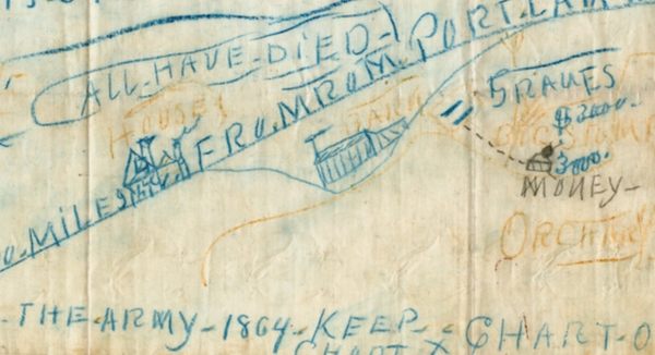
At least according to a hand-drawn map of mysterious origin.

www.atlasobscura.com
Hello CW0909
A good point!
I learned some thing today? The word indigent? Never heard that word. I made the assumption it was another term for indigenous? I was wrong. I looked up the definition of indigent?
1. :
suffering from extreme poverty : impoverished. 2. a. archaic : deficient.
We know he was Judge since 1912. I do not know the capacity of judge do they still work as lawyer when they become a judge? If not perhaps it obtained from some ones estate of some one in poverty when he acted as lawyer?
Rule 1.2 provides: “A judge shall act at all times in a manner that promotes public confidence in the independence,
integrity, and impartiality of the judiciary, and avoid impropriety and the appearance of impropriety” (emphasis added).
Thus, the code of judicial conduct applies to all of a judge’s
activities, both judicial and personal and both on and off the
bench.
In general, as described by Rule 3.1, a judge must not
participate in extrajudicial activities that will interfere with the
proper performance of judicial duties, lead to frequent dis-
qualification, or appear to a reasonable person to undermine
the judge’s independence, integrity, or impartiality.
Rule 3/10 A lawyer must cease operating as a lawyer and wind up any legal practice if called on by the state to become a Judge. So if Judge Smith obtained this Map from an 'indigent estate of a person then it was before he was judge.
So we can rule out a 1930's scam when treasure hunting became popular in imagination during the great depression? The most likely time frame would be 1892 when many banks fail and their was rural depression.
It should be noted that there was various versions of the Spanish prisoner treasure swindle scam floating around in the 1890s also.
Regardless if the treasure story was fake or not. Whoever wrote the map had knowledge at least of the areas around Portland.
One other point to take note who ever the judge smith obtained it from appeared not to have profited from it?
Crow