
BuffaloBob
Bronze Member
- Joined
- Jan 6, 2005
- Messages
- 1,369
- Reaction score
- 263
- Golden Thread
- 0
- Location
- Rocky Mountains
- Detector(s) used
- Minelab X-Terra 705 Gold Coil
deteknixXpointer Probe
Minelab Ex-Terra 70
White's Classic II
2014-2015 Colorado Gold Camp Prospector
- Primary Interest:
- Metal Detecting
- #1
Thread Owner
1744 map
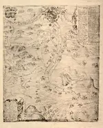
Letter and handdrawn map of New Mexico
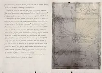
I imagine family mine maps would look like this. Pretty cool...
BB
Title [Rasquño de las provincias de la Nuevo Mexico / Other Title Photograph of Mapa del Nuevo Mexico / por el cosmografo Enrico Martinez Photograph of Mapa del Nuevo Mexico / por el cosmografo Enrico Martinez Contributor Names Martínez, Enrico, -1632. Created / Published [1906?] Subject Headings - New Spain--Maps, Manuscript--Early works to 1800--Facsimiles - North America--Discovery and exploration--Maps, Manuscript--Early works to 1800--Facsimiles - Indians of North America--West (U.S.)--Maps - Spain--Colonies--North America--Maps - New Mexico--Maps, Manuscript--Early works to 1800--Facsimiles - Oñate, Juan de,--1549?-1624--Travel--Maps - New Spain - North America - United States--New Mexico - United States--West Notes - Black and white photograph of manuscript map in the Archivo General de Indias, Seville, Spain. - Shows the travel of Juan de Oñate through northern Mexico, New Mexico, Texas, Oklahoma, and Kansas between 1598 and 1602. - Title from verso of original. - Unpublished facsimile. - Original version: 1602? 1 ms. map. Archivo General de Indias, Seville, Spain. Simancas. Descubrimientos. Nuevo Mexico. Descubrimientos, descripciones y poblaciones del Nuevo Mexico en Nuevo España, 1568 a 1602. Est. 1, Caj. 1. Leg. 3/22, Patronato 12. - Original described in: Relación descriptiva de los mapas, planos, & de México y Floridas / Pedro Torres Lanzas. Sevilla : Impr. de El Mercantil, 1900. vol. 1, p. 44, no. 49. - Lowery, 87 - Available also through the Library of Congress Web site as a raster image. - Facing the map on the recto is a manuscript transcription in ink of the text appearing on the verso of the original. - Includes inset showing the gulf coast of Texas and Mexico and numbered list of Spanish colonial settlements and indigenous Native American settlements. - In manuscript ink on verso: alternate title, published description reference of original, and provenance of original. - Accompanied by additional reproduction of the map (55 x 39 cm.). Medium
Letter and handdrawn map of New Mexico
I imagine family mine maps would look like this. Pretty cool...
BB
Title [Rasquño de las provincias de la Nuevo Mexico / Other Title Photograph of Mapa del Nuevo Mexico / por el cosmografo Enrico Martinez Photograph of Mapa del Nuevo Mexico / por el cosmografo Enrico Martinez Contributor Names Martínez, Enrico, -1632. Created / Published [1906?] Subject Headings - New Spain--Maps, Manuscript--Early works to 1800--Facsimiles - North America--Discovery and exploration--Maps, Manuscript--Early works to 1800--Facsimiles - Indians of North America--West (U.S.)--Maps - Spain--Colonies--North America--Maps - New Mexico--Maps, Manuscript--Early works to 1800--Facsimiles - Oñate, Juan de,--1549?-1624--Travel--Maps - New Spain - North America - United States--New Mexico - United States--West Notes - Black and white photograph of manuscript map in the Archivo General de Indias, Seville, Spain. - Shows the travel of Juan de Oñate through northern Mexico, New Mexico, Texas, Oklahoma, and Kansas between 1598 and 1602. - Title from verso of original. - Unpublished facsimile. - Original version: 1602? 1 ms. map. Archivo General de Indias, Seville, Spain. Simancas. Descubrimientos. Nuevo Mexico. Descubrimientos, descripciones y poblaciones del Nuevo Mexico en Nuevo España, 1568 a 1602. Est. 1, Caj. 1. Leg. 3/22, Patronato 12. - Original described in: Relación descriptiva de los mapas, planos, & de México y Floridas / Pedro Torres Lanzas. Sevilla : Impr. de El Mercantil, 1900. vol. 1, p. 44, no. 49. - Lowery, 87 - Available also through the Library of Congress Web site as a raster image. - Facing the map on the recto is a manuscript transcription in ink of the text appearing on the verso of the original. - Includes inset showing the gulf coast of Texas and Mexico and numbered list of Spanish colonial settlements and indigenous Native American settlements. - In manuscript ink on verso: alternate title, published description reference of original, and provenance of original. - Accompanied by additional reproduction of the map (55 x 39 cm.). Medium
Last edited:

















