Doc Thorne gold...Is it an easier legend than the LDM

PotBelly Jim

Hero Member
Dec 8, 2017
878
2,874
Primary Interest:
Other
Thanks...never spent much time on Apache, just remember the sign reading "USAF Recreation Area" or something like that.

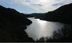
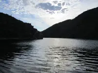
Apache Lake always kinda creeped me out. Don't know why. Spent plenty of time at Saguaro, Canyon and Roosevelt...hardly ever launched at Apache.

attachment.php
 

Attachments

  • AL.JPG
    AL.JPG
    99.3 KB · Views: 289

PotBelly Jim

Hero Member
Dec 8, 2017
878
2,874
Primary Interest:
Other
Gratuitous pics of Apache, just because ;)

attachment.php
 

Attachments

  • Al2.JPG
    Al2.JPG
    173.8 KB · Views: 291

PotBelly Jim

Hero Member
Dec 8, 2017
878
2,874
Primary Interest:
Other
One of my favorite views, the start of the adventure:

Yes, I'm going through old pics on the computin' machine...might as well post 'em, for all those who are looking forward to their next trip in.

attachment.php
 

Attachments

  • Supes.JPG
    Supes.JPG
    90.3 KB · Views: 295
Last edited:

Cubfan64

Silver Member
Feb 13, 2006
2,965
2,740
New Hampshire - USA
Detector(s) used
Fisher CZ21, Teknetics T2 & Minelab Sovereign GT
Primary Interest:
All Treasure Hunting
In part....."The mine and panning sequences were shot close to where there was a Yavapai/Apache rancheria (village) site out near Apache Lake. It was mentioned by Mike Burns.....aka "Hoomothya"... in his autobiography ( he called it quail's roost ), as well as in two other accounts (by Captain William Brown and John G. Bourke ) of the sequence leading up to the battle of Skull Cave....aka Massacre at Skeleton Cave. Lots of history out that way."

That camp, in a wash towards the north end of Bronco Butte and across from the ADOT yard, was close enough to where one would have been able to hear, on a still night, the sound of the Salt River rapids which are now under Apache Lake. The other camp mentioned, was probably the one across the river, where Willow Creek entered the Salt, also now under the lake.

The black and white image came from an article I found awhile ago (that I can't seem to find right now) by an author interested in Yavapai history and culture. Mike Burns was his "source" and Mike pointed out this spot as being "Quail's Roost" where Yavapai would gather for celebrations etc... The color photo is one I took of the same area a few years ago.

attachment.php


attachment.php


I found the source for the black and white photo - it was "The Southeastern Yavapai" by E.F. Gifford from 1932. Here is how the campsite area was described by Mike Burns...

attachment.php


d8AAAAAElFTkSuQmCC

AS93gGaLLbyIAAAAAElFTkSuQmCC
 

Attachments

  • Campsite.JPG
    Campsite.JPG
    84.3 KB · Views: 170
  • Capture.PNG
    Capture.PNG
    405.6 KB · Views: 176
  • Capture.PNG
    Capture.PNG
    123.8 KB · Views: 171
Last edited:

Cubfan64

Silver Member
Feb 13, 2006
2,965
2,740
New Hampshire - USA
Detector(s) used
Fisher CZ21, Teknetics T2 & Minelab Sovereign GT
Primary Interest:
All Treasure Hunting
Evidently you missed the part where Jim and his friend Kurt threatened people who tried to trespass on their "secret" places.

I've heard a few stories about Jim and his threats but never experienced them firsthand. I don't think Jim trusted me at all - he didn't like that I knew so many from so many different "camps" in the LDM community - he always told me I needed to pick one because by being friendly with them all meant I would never get any real information as everyone would think I was sharing with the other "team."

I don't like playing games like that, so I never did join one side or another - I think I'm fairly trusted by most everyone. If someone tells me something in confidence, I do my utmost best to not share that information with anyone else. I've probably slipped up a time or two over the years but it would have been by accident or faulty memory.

Kurt P on the other hand rubbed me the wrong way really early on and his public and personal threats to stay away from "his group's" areas (which were Jim's old areas that he claims Jim "gave" to him) didn't set well with me or the other people who he threatened.
 

wrmickel1

Bronze Member
Nov 7, 2011
1,854
1,392
Jamestown ND
Detector(s) used
Garrett 2500
Primary Interest:
Other
Kurt
Is nowhere near Jim's area anymore! I would most likely be looking or partners with Clay.

Just a thought

Babymick1
 

Cubfan64

Silver Member
Feb 13, 2006
2,965
2,740
New Hampshire - USA
Detector(s) used
Fisher CZ21, Teknetics T2 & Minelab Sovereign GT
Primary Interest:
All Treasure Hunting
Kurt
Is nowhere near Jim's area anymore! I would most likely be looking or partners with Clay.

Just a thought

Babymick1

I'm not sure I understand your second statement - who would most likely be looking and did you mean for instead of or? You're not insinuating that Kurt is trying to partner with Clay?
 

wrmickel1

Bronze Member
Nov 7, 2011
1,854
1,392
Jamestown ND
Detector(s) used
Garrett 2500
Primary Interest:
Other
I'm not sure I understand your second statement - who would most likely be looking and did you mean for instead of or? You're not insinuating that Kurt is trying to partner with Clay?

Yes most likely, I kn

Yes, I know Kurt is in Clay's area or maybe he just likes to hang out at the wasp.

Babymick1
 

PotBelly Jim

Hero Member
Dec 8, 2017
878
2,874
Primary Interest:
Other
The black and white image came from an article I found awhile ago (that I can't seem to find right now) by an author interested in Yavapai history and culture. Mike Burns was his "source" and Mike pointed out this spot as being "Quail's Roost" where Yavapai would gather for celebrations etc... The color photo is one I took of the same area a few years ago.

attachment.php


attachment.php


I found the source for the black and white photo - it was "The Southeastern Yavapai" by E.F. Gifford from 1932. Here is how the campsite area was described by Mike Burns...

attachment.php


d8AAAAAElFTkSuQmCC