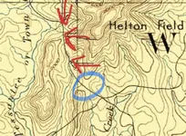
Does this black line on the 1892 map appear to be a road to you?

AmericanGeode

Jr. Member
Joined
Nov 23, 2020
Messages
54
Reaction score
30
Golden Thread
0
Location
Cleveland, Georgia
Detector(s) used
Nokta Simplex+
Primary Interest:
All Treasure Hunting
I have attached the 1892 map in its entirety, and a section with 3 arrow I added to mark a potential old road.
I believe the area where I marked corresponds to some old logging trails.
Seeking second opinion as this old map does not have a legend.
Please double click or zoom in to see my 3 red arrows pointing to the black line in question.
Thank you very much.
By the way, this map came from usgs.gov.
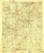
GA_Dahlonega_247711_1892_125000_geo (1)_road marked.webp
 

The medium dashed lines are county boundaries. The thinner black lines are routes. The map locational accuracy is only about 200 feet at best. Be careful if you are exploring an area based on this map.

You can download the description of symbols on Topo maps HERE

You can download any or all of the more than 1/4 million historical and current topo maps as well as the coastal topographic surveys HERE :thumbsup:
 

You will be able to verify the road/trail by detecting bits and pieces of horse/oxen shoes, wagon parts, etc.

To truth the map, look for natural stream crossings (places where the stream is shallow and wide), saddles and gaps, springs, flats, optimal camp areas, etc.

Looks like that route crossed a saddle near your middle arrow. There may be evidence of a camp/rest area there.
Usually they would let the stock rest a minute and check/adjust straps, cinches, ropes, etc.

FUN!!
 

Last edited:
Sure looks like coach trails the way your black line and others follow contours to pass through the varied terrain elevations.
I didn't study the relation to the clearly marked waters. Older trails might have utilized water more.
 

Sometimes it’s pretty difficult to relate these maps to the real world.
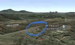
Here is a decent stab at a pin point.

It’s a natural place to dive off into Jenny creek.
0D3F00AE-FE10-4DD1-9006-168B44A652BF.webp

532A32E3-F42F-4908-8B36-E6B30B480CC8.webp

From there work your way north up the bottom of that draw to the next saddle (just south of that nice looking pond). First creek crossing appears to be near where someone has recently been doing some grading near a pond. Near your middle arrow.
 

Last edited:
I’d be talking up the land owners at the head of Moose Creek to the south east of you.
Looks promising on the aerial. Maybe those fields are cultivated right now?

Ball Play creek also has my curiosity.
 

Last edited:
I have to agree with the others the lines are probably some kind of road or trail. I have some of the same maps from the USGS as well, which can be printed on a large scale printer. Mine are of the East Tennessee area. I am using them to locate possible sites for lost homes and towns.
 

...

You can download any or all of the more than 1/4 million historical and current topo maps as well as the coastal topographic surveys HERE

These have been removed for Arizona ... "Historical" topos are not available through the links provided in MyLandMatters
 

These have been removed for Arizona ... "Historical" topos are not available through the links provided in MyLandMatters

Thanks for pointing that out. :thumbsup:

They haven't been removed, they just changed the location without telling anyone. The government does that every few years, sumthin' about a new chota in town. I'll fix those links right after I deal with a bunch of other disappearing government resources.
 

Where your arrows are is US 129. No need to even get out of your car to get there. Use the link above in post by Tesorodeoro, pull up map you first posted, go to map chooser and pull up recent dated map and you will see the US highway is where your at. I have hiked up through the woods to the highway from Paradise Valley Campground. Nice looking minerals on the highway there in the hillside cuts. Best gold in area is the GPAA claim across the creek from mine on your map
 

Last edited:
Where your arrows are is US 129. No need to even get out of your car to get there. Use the link above in post by Tesorodeoro, pull up map you first posted, go to map chooser and pull up recent dated map and you will see the US highway is where your at. I have hiked up through the woods to the highway from Paradise Valley Campground. Nice looking minerals on the highway there in the hillside cuts. Best gold in area is the GPAA claim across the creek from mine on your map

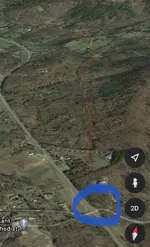
I’m going to have to disagree. Starting out at the intersection I have circled in blue, Highway 129 peels off to the north west, where the route shown on the old map follows a more northerly route up a draw to a saddle.

I’ve attached a screenshot looking north. General location of old route shown in red.

DBAE7B86-348C-4D74-9DC6-CBED1469A029.webp

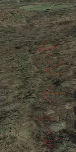
You can even see what looks like signs of the old roadbed.

C6B1EDDA-7B71-4763-AB95-2A9545BA73B5.webp

Boots on the ground needed!! Maybe the OP will check in eventually.
 

Last edited:
it's a road, old road not used any more if it's not on a updated map
 

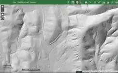
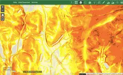
Not sure how much help this will be but here are some screenshots of the same spot: first is natural color imagery, then hillshade, last is slope.
Screen Shot 2021-03-10 at 12.16.56 PM.webp Screen Shot 2021-03-10 at 12.17.35 PM.webp Screen Shot 2021-03-10 at 12.17.07 PM.webp
 

Top Member Reactions

Users who are viewing this thread

Latest Discussions

Back
Top Bottom