Dowsing request of an earth image

Cochetopa

Jr. Member
Joined
May 2, 2009
Messages
65
Reaction score
23
Golden Thread
0
Location
Galt's Gulch, Colorado
Detector(s) used
Minelab Eureka Gold
Primary Interest:
Prospecting
Hi,
I am experiencing a (momentary?) loss of confidence in a project on which I am working. Would someone dowse the attached image for me and report if you detect anything? Thank you.
Sincerely,
C
 

Attachments

  • Colorado1.webp
    Colorado1.webp
    250.7 KB · Views: 592
C i get a gold vault should be some spainish sign's in the area.
 

Attachments

  • Colorado1 (Medium).webp
    Colorado1 (Medium).webp
    129.1 KB · Views: 512
Hi, Okiedowser,

Thank you for your help. My result is virtually identical with yours, only different words: booty (anything of value taken by force), gold-silver alloy bars. I used the word "booty" because for me target words like "treasure" or "spanish gold vault" stir up emotions in me which conflict with my remaining impartial to the result. It's a problem I have had ever since day one when I started dowsing. Also, you got me to thinking about how very subtly my unconscious tries to induce a result that I >>think<< ought to be right...not a good thing for a dowser.

Again, THANKS for your work.

Sincerely,
-C
 

Cochetopa, I'll check it too, soon as get time....tomorrow might be tornado weather though.
 

Cochetopa, green circles are natural caves, red circles for tunnel/mine shaft entrance, red Xs coins or other treasure. Green Xs archaeological type signals, which sometimes are Spanish markers.
 

Attachments

  • Colorado1-X-Cochetopa.webp
    Colorado1-X-Cochetopa.webp
    360.3 KB · Views: 396
Red_desert,
Thank you for your work. You (and okiedowser) gave me a lot to chew on. This location isn't far from my home. When warmer weather arrives in Colorado, I plan to investigate on-site. I will take photos and report back in this thread what my experiences are.
Sincerely,
C
 

Cochetopa said:
Red_desert,
Thank you for your work. You (and okiedowser) gave me a lot to chew on. This location isn't far from my home. When warmer weather arrives in Colorado, I plan to investigate on-site. I will take photos and report back in this thread what my experiences are.
Sincerely,
C
Sounds good....photos taken on trips work nice too! :thumbsup:
 

Hi Cochetopa,
Dowsing revealed....
Small (bold line) green square: Gold bars, mine opening/shaft
Large green square: Alluvial gold deposits, spanish/native american gold mine area.
Green circles: Gold attraction.
Thanks for posting your picture,
Jon
 

Attachments

  • Colorado1dowsed.webp
    Colorado1dowsed.webp
    252.7 KB · Views: 538
Teleprospector,
Thank you for this help. Again, I will be going to investigate once my Colorado weather warms up and I'll report what is found.
Sincerely,
C
 

I went to the site

Hi, All, and esp. Okiedowser, Red_desert, and Teleprospector,

I drove to the dowsed site and this was my experience.

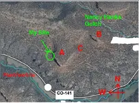
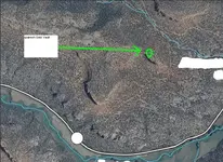
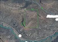
In my attached photos I have again presented an aerial view of the site, but with labels to buttes A and B, and region C which turned out to be a natural amphitheatre manufactured by erosion. There is a patented lode mining claim NE of butte B.

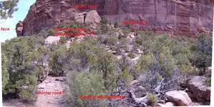
The photo “EastFaceButteB” shows regional geology. The buttes are sedimentary mud and sand stone laid down 250 million years ago when Colorado was an inland sea. The basement rock beneath is Precambrian gray granite that is 600+ million years old.

I had not planned on finding patented, private property out there in the midst of nowhere. The canyon east of butte B is unfortunately posted, so I tried to avoid butte B. Before I return next, I will locate and contact the mine owner to investigate his claim’s boundaries, etc.

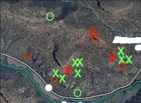
There are quartz veins embedded in the amphitheatre floor C. I checked the veins I located using my Minelab Eureka Gold metal detector, but none produced a metal response. The sediment lying on the amphitheatre’s granite floor is sand and silt from surrounding, weathered rock walls.

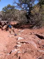
Prior to this trip, my own personal dowsing results indicated “booty” at the west face of butte A, which correlated with some of Teleprospector’s results. So, I spent most of my time there using my no-frills L-rod and metal detector, but found nothing worth noting. I clawed my way up the debris slope to the butte’s vertical face, but did not find anything unusual. I observed no evidence of archeological markings, but have no training or experience in this area. The sedimentary rock was often covered with colorful stains or surface changes, but nothing which looked to me to be man caused.

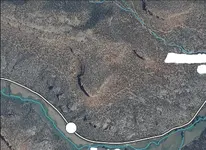
Red_desert and Okiedowser: I took the photo of butte B’s western face as I headed for home with the hope that a view of the butte from that perspective might prove fruitful for a dowse.

Oh, final notes to everyone: (1) I’m 65, so my physical stamina isn’t what it used to be. My mistake for this initial trip was planning to do too much, but it was a good lesson to learn; (2) It was quite a hike and climb from the highway up onto the granite layer and from there to the buttes; (3) While the weather was gorgeous, it was also windy with gusts that made impossible using my L-rod as a location pin pointer; (4) While I did not return home with treasure, I did enjoy a good time and met a young family of big horn sheep which was a surprise.

Thanks for your feedback. I intend to go back, but I might have to wait until autumn when the weather cools down.

Sincerely,
C

View attachment 638319View attachment 638320View attachment 638321View attachment 638322View attachment 638323View attachment 638324View attachment 638325View attachment 638318
 

I went to the site

Geez, something went wrong with attaching my photos. I will try again.
-C
AmpitheatreFloorQuartzVein.webpEastFaceButteB.webpPlanViewSite.webpThingPartners.webpWestFaceButteA.webpWestFaceButteAFromHighwayBelow.webpWestFaceButteASlope.webpWestFaceButteB.webp
 

WoW, COCHETOPA,

Awesome photos. If those do not get a TH seeker's blood moving-nothing will.

I might suggest that you have someone versed in "signs and symbols" to take a look at your photos. I can see some interesting rock formation shapes such as the "heart-shaped' one. It appears that part of it has broken off but the "heart-shape" is still there. Some Spanish symbols were really big so that they could be seen from a distance. There may be more I missed or that were not shown in the photos.

Just my two cents,

prairiepup
 

Good photo’s...prairepup is correct..I think that all treasure hunters should be aware of Spanish and KGC treasure symbols...Just some of them can be found here.. Art
Treasure Marks/Signs
 

Took one of your shots and here's my amateurs eye take on it.

Could very well be an old Spanish trail.

See the face on the left.
Pointer rock in lower foreground, points to second pointer, which is pointing towards the crack/opening.
Maybe the photo, but I don't like the look of the rock situated above the opening, possible death trap.
Lastly, the two big boulders look out of place, notice most of the rocks are sharp edged, yet these two are rounded, and the horizontal rounded lines (?) don't make sense with the rest of the geology.


Ooops almost forgot, if those two boulders make a heart, a broken heart can mean danger.
 

Attachments

  • WestFaceButteASlope.webp
    WestFaceButteASlope.webp
    256.9 KB · Views: 214
Colorado1[1].webpIn the upper NE of the map there are some treasure markers pointing east. # 1 is an open mine entrance and a treasure. # 2 is another treasure in the same tunnel...Art
 

Looks like you've got yourself Cochetopa, a wonderful and beautiful place to explore....makes us all a bit envious I'll bet!:thumbsup:
 

I returned to the location

When I began posting on TNet, I vowed to myself I would post a real accounting of my adventures, warts and all. Here goes.

I returned to this location yesterday, which is 11 miles west of Whitewater, CO, just off highway CO-141 at Nancy Hanks Gulch. Beforehand, I dowsed the depth to my TARGET at 5 inches. After hiking into the specific site, I dowsed my TARGET. I turned on my metal detector and set its frequency to 6.4 KHz for deepest penetration (the machine has capability to use one of three user selected frequencies). I swung the coil, and the response was a loud, BEEP. I knew there was metal down in the ground by the volume in my headphones. I dug the TARGET and at 5 inches retrieved an empty 2-cycle engine oil can. :laughing7: ??? There was also a bottle cap nearby.

Dead tree stumps in the area showed someone had been there years ago cutting Pinion pine firewood.

On my hike back to the car, I metal detected in the amphitheatre C between buttes A and B for gold nuggets using 60 KHz frequency for max sensitivity to small metal targets. The ground has only a slight gradient, but rivulets have formed exposing Precambrian bedrock. I beep’d the cracks in these bedrock rivulets, but found nothing. I found two pennies and misc. trash along the 4WD ATV trail.

That’s my story. If anyone else cares to give it a shot, be my guest. Just let the rest of us on the forum know what happens, ok?

Sincerely,
-C
 

Attachments

  • PlanViewSite02.webp
    PlanViewSite02.webp
    156.5 KB · Views: 109
  • MySitePerspective.webp
    MySitePerspective.webp
    204.5 KB · Views: 131
  • MySiteCloseUp.webp
    MySiteCloseUp.webp
    216.7 KB · Views: 125
  • AmpitheatreRivulet.webp
    AmpitheatreRivulet.webp
    210.4 KB · Views: 131

Top Member Reactions

Users who are viewing this thread

Back
Top Bottom