Elevation Drops?

goldmap

Tenderfoot
Joined
Feb 25, 2016
Messages
5
Reaction score
3
Golden Thread
0
Primary Interest:
All Treasure Hunting
I keep running into people mentioning "elevation drops" are good places to look for gold. However when I google the term (or advanced search here) I come up with very little specifics and the mentions of elevation drops usually don't mention why.

I know an elevation drop causes rapids or the dirt to wear away closer to bedrock but I'm not sure if I look in the rapids of elevation drop or after it in the river. (on google earth the elevation drop can go over a long span of river)

Are there any rules of thumb when researching elevation drops what to look for? (other than the obvious bottom of waterfall)

thank you
 

Upvote 0
Sure:
1. Look for the spots where the slope changes from steep to slower/shallower.
2. Look for areas where baseball/basketball sized rocks have been dropped by high water - the gold will drop there too most likely
 

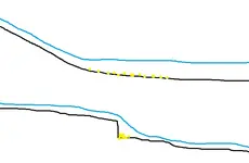
I'm not super experience but here's what I understand: In rivers, like Kevin said, the water will slow down and drop gold when it goes from steep to flat because the water doesn't move as fast, this works for width of a river/stream as well. Other thing that's on a smaller scale usually is where there's little drops in bedrock it can act like a riffle and gold will sink down behind it, I made some drawings for you.
Untitled.webp
 

thank you @kevinincolorado and @owent (great pic)

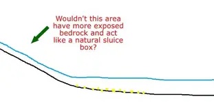
so after the elevation drop is complete is the place to start? I had it in my head that in the slopes is where it's usually washed to bed rock and wouldn't that trap a bunch of gold, keep in mind i am as new as newbie gets. lol glad i asked

Untitled.webp

also, anybody have these spots figured out mathematically for a river? like high level prospecting from google earth? It could be done i assume if you download all the elevations for a river couldn't it? (i'm a wannabe programmer and google maps makes elevation data for free https://developers.google.com/maps/documentation/elevation/intro just saying lol)
 

thank you @kevinincolorado and @owent (great pic)

so after the elevation drop is complete is the place to start? I had it in my head that in the slopes is where it's usually washed to bed rock and wouldn't that trap a bunch of gold, keep in mind i am as new as newbie gets. lol glad i asked

View attachment 1278187

also, anybody have these spots figured out mathematically for a river? like high level prospecting from google earth? It could be done i assume if you download all the elevations for a river couldn't it? (i'm a wannabe programmer and google maps makes elevation data for free https://developers.google.com/maps/documentation/elevation/intro just saying lol)

Correct, where the water is fast it is more likely to be stripped to bedrock and if it's irregular then it will trap gold and be good for crevicing perhaps. Down in the flatter spots though is where gold will simply just drop to the bottom without a trap simply because the water can't push it along anymore. Both areas potentially hold gold, just different types of prospecting. As far as google earth prospecting, I do it all the time, but it can only give you a very general idea of where to go, rivers are so variable that you really have to get on the ground and test to find out where the gold is going. Also, I wouldn't trust google earth elevation data to me more accurate than within 10, 20, maybe 40 or more feet of the actual elevation. Gold is predictable, but those rules it sometimes follows are really only guidelines. You're going to here this a million times, like I did, but gold is where you find it :tongue3:.
 

Last edited:
Look up topography , elavation has to do with it . It will help you find benches , water , rivers Etc a book on orienteering will help also . it will explain a lot of questions for you .
 

Last edited:
I keep running into people mentioning "elevation drops" are good places to look for gold. However when I google the term (or advanced search here) I come up with very little specifics and the mentions of elevation drops usually don't mention why.

I know an elevation drop causes rapids or the dirt to wear away closer to bedrock but I'm not sure if I look in the rapids of elevation drop or after it in the river. (on google earth the elevation drop can go over a long span of river)

Are there any rules of thumb when researching elevation drops what to look for? (other than the obvious bottom of waterfall)

thank you

You can also think of it as high pressure vs low pressure. When water is flowing down a steep slope or through a narrow channel, that would be high pressure. Where as a shallow slope or a wide flat area would be low pressure.
There will be a transitional point in the system where the pressure gradient drops. When the pressure gradient drops below that required to move a particular material (gold) it will drop out of the system. This could be a wide aluvial fan in a great river, or an inside bend on a small stream.

Apply that to slopes and you should grasp the idea.
 

Slope angle changes (Lessening of the angle) are good places to look for gold but where a stream or river widens out significantly is also a good place to check out. As the water widens out it's going to slow down and drop gold. I've got a place I want to check out that the stream/wash comes out of a tight canyon and the bed almost triples in width. Going to be tough to access with any kind of production equipment though so most likely it will be detecting only.
 

thank you all for the feedback, it's got me started down some more rabbit holes of researching.

@ragnor high pressure vs low pressure when reading the river is a fresh way to look at things also, and good luck on your new claim
 

Top Member Reactions

Users who are viewing this thread

Back
Top Bottom