Equipment(s) for Underground Geophysical Mapping

openpit

Newbie
Sep 27, 2017
3
0
Primary Interest:
All Treasure Hunting
Hi Fellow Treasure Hunters,

I have access to a great number of mountains in an undisclosed location in Asia. These mountains are rich in many metals and minerals including copper, chromium, manganese, molybdenum, lead, zinc, antimony, indium, zirconium and PGM (shiny shiny) ores. I am looking forward to obtain advice from a geologist to guide me about the EQUIPMENT required to map certain locations i.e. create a whole geophysical survey of the elements located UNDERGROUND to a depth of 100 meters in any location. I would want to know depth measurement, size of deposit, consistency of earth around it and any other information that can be achieved that I may have missed here.

Budget is not an issue when it comes to purchasing the equipment. Your help will be highly appreciated.
 

Upvote 0
How much you want? I will send you my credit card number and SS No#.
 

Long before you seriously consider underground geo physical mapping---I would start by geochemical testing your areas of interest.
Geochemical testing is a low cost method of searching that will allow you to search many kilometers of ground quickly and at low cost.
The anomalies you then locate by Geochemical testing would be the locations you then concentrate your Geophysical explorations.

If you have the money--I would get a good mining engineer. Contrary to what most people believe--an expert can often save you lots of money in the long run.
For example you could hire a graduate from the Colorado School of Mines in Boulder, Colorado

Barton Thom
 

Last edited:
How much are you willing to invest in the necessary equipment?

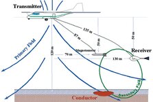
https://csegrecorder.com/articles/v...ient-em-system-applied-to-mineral-exploration

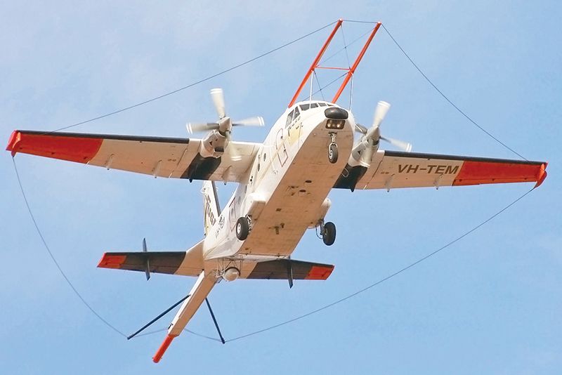
AEM-survey-large.jpg


2005-10-megatem-fig02.jpg
 

Thank you for your answers. We have already done a lot of Geo Chemical testing mainly through handheld XRF machines. Thus we know we have "mountains rich in many metals and minerals including copper, chromium, manganese, molybdenum, lead, zinc, antimony, indium, zirconium and PGM (shiny shiny) ores." Our challenge now lies at detecting the deposits i.e. their depth and size and then moving forward from there.

We interviewed a few experienced engineers but unfortunately they did not have much equipment knowledge which is integral at this point.

We have a good budget for box-based equipment and other handhelds that may be required but definitely not at a vehicular level.

We are still searching for the best possible equipment to achieve this task.

Regards
 

Don't need money, need expertise.

Expertise for what ? The type objects you list as your objective were things like: "chromium, manganese, molybdenum, lead, zinc, antimony, indium, zirconium and PGM...." Sounds like you're more into open pit industrial mining. This is a metal detecting forum. So guys here are going after coins, relics, jewelry. To the extent some are into prospecting, it will be for gold nuggets, or panning/sluicing, etc..... I don't think anyone here is into the stuff you're alluding to.

Maybe there's forums for guys into the other types minerals you are wanting to find. Good luck.
 

I have no idea why this discussion popped up for me now. I agree with the commenter above that you should talk to a graduate of the Colorado School of Mines (CSM, or mines). I did both my MS in Geophysical Engineering and my PhD in Geophysics there. I have been an adjunct faculty member there in the geophysics department for the past four years while working as a full time consultant.

The suggestion above about starting with geochemical measurements is a reasonable approach. I typically say that geophysics isn't the first step in solving any problem. The first step is creating a geographic information system (GIS) project for the area. After adding layers for topography, aerial imagery, geologic maps, property boundaries, current and previous mining sites, etc..... Then I typically collect unmanned aerial system (UAS) photogrammetry, LiDAR, and magnetometry. Magnetometer data is a very fast and inexpensive way to map geology. There are other geophysical methods would do after that depending on the geology and the type of target.
 

Top Member Reactions

Users who are viewing this thread

Latest Discussions

Back
Top