Feather river gold?

swexelman

Greenie
Sep 20, 2014
10
1
Primary Interest:
All Treasure Hunting
I have searched for a while but cant find any specific spots to try on the feather river, I have seen a video of a mine on the feather river but it doesnt say where, does anyone know of any spots with a mine near the sacremento area on the feather river? has anyone had any luck on the feather river with bigger pieces of gold?
 

Upvote 0
Outta Home Garden is the La Porte road that crosses the river there prior to the hill climb. Lotz of bedrock all over there and down stream towards Nelson creek also-John
 

The Feather is a weird duck. 3 main forks-north, middle, south. Plus many sub branches- west branch, east fork of the middle, etc. They weren't very creative with the names! You have to do your homework bigtime to find a place to prospect. Mostly claimed, some closed, and many areas with either no gold or very, very, tough access. There are many club claims throughout the system. Advanced Geologic had a pay by day deal, and I think so does the Caribou mining Assoc., Comstock club has claims up by Quincy. You mentioned down by Sac., are you wanting to detect dredge tailings? If you can be more specific we can get hopefully get ya poinyed in the right direction or show you how to find out the info for yourself. Also if you are near the Feather a better option for you might be the Butte Creek rec area.
 

The famous Will Wilcox "Feather River Nugget."
 

Attachments

  • 36ounces.jpg
    36ounces.jpg
    26.5 KB · Views: 265
I was confused I thought gold was in the feather closer to sacremento, homegarden is 3+ hours from me, ive tried auburn rec a few times only by the 49 bridge and it was heavily picked through I only came out with a few really tiny flakes, called auburn rec and they said drivers flat and yankee jims road is closed for the rest of the season unless you take yankee jims road from the colfax side, is there any public spots closer to the auburn state rec area or has anyone tried the mokelumne river by the 49 hwy bridge?
 

I was confused I thought gold was in the feather closer to sacremento, homegarden is 3+ hours from me, ive tried auburn rec a few times only by the 49 bridge and it was heavily picked through I only came out with a few really tiny flakes, called auburn rec and they said drivers flat and yankee jims road is closed for the rest of the season unless you take yankee jims road from the colfax side, is there any public spots closer to the auburn state rec area or has anyone tried the mokelumne river by the 49 hwy bridge?

Yankee jims rd and drivers flat are both open... Kayaking season on the NF American may start early this year( I already saw locals kayaking when the river hit 500cfs some locals hit around 300cfs) and Yankee Jims is the main take out.. As far as the ASRA is concerned is they have a very limited knowledge of the lands they lease and their ignorance of the state park employees are to be rivaled.. I have no experience with the feather rivers but as far as the American river are concerned some good oppurtunities are still present.. Most common for prospetors to ride the water line maybe u tooo.. Anyway maybe try crackin some rock 10-20 feet above the average flow. Often you will find the farther from the water the less picked over.. Anyway I am gonna call the asra and double check about the road closure but I was out on Yankee Jims with DGoldman not to long ago. we had the place to ourselves.. (all to common in the winter..) Anyway if I wrong about roads Ill post again
 

I was wrong.. I talked to the ASRA operator.. I was told all dirt roads in the ASRA will be closed till April.. The reason was to help prevent erosion of the roads due to the rains..

THIS is a joke.. I am gonna email Scott Liske who I was told new more about this bullshit.. In all the years I have been enjoying the Yankee Jims area I have never ever seen the road closed thru the winter.. Oh well it is what it is I suppose..
Less and less real public lands or roads for that matter!!!!! Pretty soon were all gonna be criminals and highgraders..
 

That entire stretch has become a ghost area with these rains..
Almost seems like Kryptonite

:)

Thanks for hunting MM.
Heavy Pans
 

WHO closed Yankee Jims? It's a public road. People live there.

The ASRA doesn't lease any land. They have an auxiliary management contract.
 

Last edited:
I do know on the Colfax side of yankee Jims has a gate that Can be Closed and Locked.

Maybe I will travel there manana...
 

Well I sent ASRA an Email though it usually takes them about three months or so to respond to me. Me personally I have a very hard time my mind around all these laws and crap. And honestly the older I get the less regard and respect I have for them.

Anyway I have my doubts about Yankee jims Road but the Operator told me the Foresthill side of Yankee jims road will continue to be open.. A joke? right? I doubt it.. anyway ASRA emailed me this awhile ago supposed to be the current rules for ASRA .. But from his email I got the distinct feeling that the guy who emailed had little to no clue on the rules.. ................................................................................


Hello Mr. Marshall.

I have been requested to follow up with questions that you have regarding the mineral collection regulations at Auburn State Recreation Area. I have attached a current working document that lists most of the applicable code sections and policies that pertain to this activity. We will be checking other public documentations for consistency with these regulations. I hope that this document will help to clarify any questions that you might have. If you have any others, please feel free to contact me.

Regards,

Bill D.


Bill Deitchman

State Park Ranger

Auburn State Recreation Area

501 El Dorado Street

Auburn, CA 95603
Phone: 530-823-4164


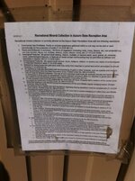
04/2014 Recreational Mineral Collection in Auburn State Recreation Area
Recreational mineral collection is currently allowed at the Auburn State Recreation Area with the following restrictions:
1. Commercial Use Prohibited. Rocks or mineral specimens gathered within a unit may not be sold or used commercially for the production of profit (T-14 CCR 4611c). 2. Plants and Driftwood. In summary - All forms of vegetation (including roots, moss, flowers, etc.) are protected e.g. one may not pick, dig up, cut, mutilate, destroy, injure, disturb, move, etc. (T-14 CCR 4306). 3. Geological Features. No person shall destroy, disturb, mutilate, or remove earth, sand, gravel, oil, minerals, rocks, paleontological features, or features of caves except rockhounding may be permitted as defined and delineated in Section 4611(T-14 CCR 4307). 4. Archeological Features. No person shall remove, injure, disfigure, deface, or destroy any object of archeological, or historical interest or value (T-14 CCR 4308). 5. Material for sluice boxes and gold pans shall only come from beaches or gravel bars which are subject to annual flooding (T-14 CCR 4611g). 6. No hazardous materials associated with the processing of gold or other minerals, such as cyanide and mercury shall be permitted within the State Recreation Area (Posted Order No. 690-013-2010). 7. Use of Tools for Mineral Collection. The use of non-motorized small tools (for example shovels and hand trowels) is authorized in areas open for recreational mineral collection at Auburn SRA (i.e. beaches or gravel bars which are subject to annual flooding) (Auburn State Recreation Area policy 6/7/10). 8. Private property shall not be left unattended for more than 48 hours. Property left in violation of this section shall be subject to confiscation (Posted Order No. 690-013-2010). 9. Motorized sluicing is only allowed during the Department of Fish and Wildlife regular dredging season (Posted Order No. 690-013-2010). 10. All California Fish & Wildlife laws and regulations regarding sluicing operations must be complied with (T-14 CCR 228 & 228.5), (Posted Order No. 690-013-2010). 11. Recreational suction dredging is not allowed while the state ban on suction dredging is in effect (Fish and Wildlife Code 5653.1) (Posted Order No. 690-013-2010). * 12. Rockhounding. Defined as being the recreational gathering of stones and minerals found occurring naturally on the undisturbed surface of the land, including panning for gold in the natural water-washed gravel of streams (T14 CCR 4611).  Maximum Take. One person may gather, in one day in one unit, not more than 15 pounds of mineralogical material or not more than one specimen plus 15 pounds of mineralogical material (T-14 CCR 4611d).  Areas for Swimming and Boating. In state recreation areas rockhounding may not be practiced in areas designated for swimming or for boat launching (T-14 CCR 4611f).  Area Limited to Collection. Beaches or gravel bars which are subject to annual flooding on streams (T-14 CCR 4611g).  Indian Artifacts. Rockhounding specifically does not include gathering of Indian arrowheads, Indian stone tools, or other archeological specimens, even when such specimens may be found occurring naturally on the surface. (T-14 CCR 4611h)  Panning for Gold. Panning for gold is considered to be “rockhounding” as the term is applied in the Department. Muddy water from panning operations must not be visible more than 20 feet from the panning operation (T-14 CCR 4611i). 13. Metal Detectors may be used with the following restrictions (Posted Order No. 690-013-2010):  Metal detectors may only be used for searching for recently lost items.  Metal detectors may not be used in area possessing historic or prehistoric resources.  No historic or prehistoric items discovered by metal detection or otherwise, may be collected or possessed.  The area west of Hwy. 49 in El Dorado and Placer Counties is closed to the use of metal detectors. 14. The following areas are closed to motorized mineral collection (Posted Order No. 690-013-2010):  Upstream on the North Fork of the American River from the boundary of Folsom Lake State Recreation Area to the high bridge on the Foresthill Road and on the Middle Fork of the American River from it’s confluence with the North Fork upstream to the east end of Louisiana Bar.  Lake Clementine area from ¼ mile below the North Fork Dam to ½ mile upstream of the Lake Clementine Day Use Area.  During the whitewater boating season, at the whitewater boating put-ins/take-outs at Oxbow, Ruck-a-Chucky, Iowa Hill, and Ponderosa Way.  The area west of Hwy. 49 in El Dorado County is closed to all forms of mineral collection or rockhounding.
*Under California Fish & Wildlife Code Section 5653.1, suction dredging has been temporarily halted until an environmental impact report and related regulations are completed by the California Department of Fish & Game
 

does anyone know if salmon falls rd bridge area is open? anyone have any luck their recently?
 

Well I sent ASRA an Email though it usually takes them about three months or so to respond to me. Me personally I have a very hard time my mind around all these laws and crap. And honestly the older I get the less regard and respect I have for them.

Anyway I have my doubts about Yankee jims Road but the Operator told me the Foresthill side of Yankee jims road will continue to be open.. A joke? right? I doubt it.. anyway ASRA emailed me this awhile ago supposed to be the current rules for ASRA .. But from his email I got the distinct feeling that the guy who emailed had little to no clue on the rules.. ................................................................................


Hello Mr. Marshall.

I have been requested to follow up with questions that you have regarding the mineral collection regulations at Auburn State Recreation Area. I have attached a current working document that lists most of the applicable code sections and policies that pertain to this activity. We will be checking other public documentations for consistency with these regulations. I hope that this document will help to clarify any questions that you might have. If you have any others, please feel free to contact me.

Regards,

Bill D.


Bill Deitchman

State Park Ranger

Auburn State Recreation Area

501 El Dorado Street

Auburn, CA 95603
Phone: 530-823-4164


04/2014 Recreational Mineral Collection in Auburn State Recreation Area
Recreational mineral collection is currently allowed at the Auburn State Recreation Area with the following restrictions:
1. Commercial Use Prohibited. Rocks or mineral specimens gathered within a unit may not be sold or used commercially for the production of profit (T-14 CCR 4611c). 2. Plants and Driftwood. In summary - All forms of vegetation (including roots, moss, flowers, etc.) are protected e.g. one may not pick, dig up, cut, mutilate, destroy, injure, disturb, move, etc. (T-14 CCR 4306). 3. Geological Features. No person shall destroy, disturb, mutilate, or remove earth, sand, gravel, oil, minerals, rocks, paleontological features, or features of caves except rockhounding may be permitted as defined and delineated in Section 4611(T-14 CCR 4307). 4. Archeological Features. No person shall remove, injure, disfigure, deface, or destroy any object of archeological, or historical interest or value (T-14 CCR 4308). 5. Material for sluice boxes and gold pans shall only come from beaches or gravel bars which are subject to annual flooding (T-14 CCR 4611g). 6. No hazardous materials associated with the processing of gold or other minerals, such as cyanide and mercury shall be permitted within the State Recreation Area (Posted Order No. 690-013-2010). 7. Use of Tools for Mineral Collection. The use of non-motorized small tools (for example shovels and hand trowels) is authorized in areas open for recreational mineral collection at Auburn SRA (i.e. beaches or gravel bars which are subject to annual flooding) (Auburn State Recreation Area policy 6/7/10). 8. Private property shall not be left unattended for more than 48 hours. Property left in violation of this section shall be subject to confiscation (Posted Order No. 690-013-2010). 9. Motorized sluicing is only allowed during the Department of Fish and Wildlife regular dredging season (Posted Order No. 690-013-2010). 10. All California Fish & Wildlife laws and regulations regarding sluicing operations must be complied with (T-14 CCR 228 & 228.5), (Posted Order No. 690-013-2010). 11. Recreational suction dredging is not allowed while the state ban on suction dredging is in effect (Fish and Wildlife Code 5653.1) (Posted Order No. 690-013-2010). * 12. Rockhounding. Defined as being the recreational gathering of stones and minerals found occurring naturally on the undisturbed surface of the land, including panning for gold in the natural water-washed gravel of streams (T14 CCR 4611).  Maximum Take. One person may gather, in one day in one unit, not more than 15 pounds of mineralogical material or not more than one specimen plus 15 pounds of mineralogical material (T-14 CCR 4611d).  Areas for Swimming and Boating. In state recreation areas rockhounding may not be practiced in areas designated for swimming or for boat launching (T-14 CCR 4611f).  Area Limited to Collection. Beaches or gravel bars which are subject to annual flooding on streams (T-14 CCR 4611g).  Indian Artifacts. Rockhounding specifically does not include gathering of Indian arrowheads, Indian stone tools, or other archeological specimens, even when such specimens may be found occurring naturally on the surface. (T-14 CCR 4611h)  Panning for Gold. Panning for gold is considered to be “rockhounding” as the term is applied in the Department. Muddy water from panning operations must not be visible more than 20 feet from the panning operation (T-14 CCR 4611i). 13. Metal Detectors may be used with the following restrictions (Posted Order No. 690-013-2010):  Metal detectors may only be used for searching for recently lost items.  Metal detectors may not be used in area possessing historic or prehistoric resources.  No historic or prehistoric items discovered by metal detection or otherwise, may be collected or possessed.  The area west of Hwy. 49 in El Dorado and Placer Counties is closed to the use of metal detectors. 14. The following areas are closed to motorized mineral collection (Posted Order No. 690-013-2010):  Upstream on the North Fork of the American River from the boundary of Folsom Lake State Recreation Area to the high bridge on the Foresthill Road and on the Middle Fork of the American River from it’s confluence with the North Fork upstream to the east end of Louisiana Bar.  Lake Clementine area from ¼ mile below the North Fork Dam to ½ mile upstream of the Lake Clementine Day Use Area.  During the whitewater boating season, at the whitewater boating put-ins/take-outs at Oxbow, Ruck-a-Chucky, Iowa Hill, and Ponderosa Way.  The area west of Hwy. 49 in El Dorado County is closed to all forms of mineral collection or rockhounding.
*Under California Fish & Wildlife Code Section 5653.1, suction dredging has been temporarily halted until an environmental impact report and related regulations are completed by the California Department of Fish & Game

I saw this same thing on the porta potty at Yankee Jims bridge. Look.ImageUploadedByTreasureNet.com1417587506.382709.jpg

Is Yankee Jims part of Auburn Recreational area?

Thanks for that clarification on Yankee Jims Rd. I guess I did not know how extensive the road actually is. I was only thinking of the Colfax side.
 

Maybe just today with the inch that fell today, but, the gate on the colfax side was locked up where the loose gravel turns to slick mud.

Turned and panned just north of Mineral Bar, up on the benches.. Strayed away from the desire to lay the box down and dig
Was a chilly winter setting, thats for sure

Heavy Pans Ya'all

I suppose since they left the other side of the road open they aint technicaly closed the road.. But they made it much more difficult for all people who enjoy that area to visit..
I feel for the kayakers this season.. A lot of them do the Mineral bar to Yankee jims stretch 2-3 times in a single day.. Now with the easiest acsess to the take out area is gone they'll be lucky to make the run twice.. It seems BOLT CUTTERS are becoming an essential tool for prospectors.. Hell anyone who wants to enjoy public lands for that matter...

If it is a temporary close of the road it should be fine. If anything we should understand why it's closed off for that the time being. Erosion on that road can be a serious problem. This is ok only if it's closed because of the heavy rain. Other wise there's a problem.
 

H&f9090RO... These rains are far from bad or extreme.. Nor did the heavy rains in 2012 close these roads.. Though their was a landslide on the Foresthill side of Yankee Jims road by Devil Falls.. Didn't even close it for that


We pay taxes to keep roads open and maintained.. that simple.. I don't pay taxes so they can pick and choose what is easier or conveint or cheap. Make no mistake give these basterds an inch they run you down for miles to come!!!!
 

Top Member Reactions

Users who are viewing this thread

Back
Top