Gold and Silver found in New Mexico

firebird21

Jr. Member
Joined
Dec 28, 2008
Messages
44
Reaction score
2
Golden Thread
0

Attachments

  • Jim-Jeep-Instrumts2006.webp
    Jim-Jeep-Instrumts2006.webp
    158.6 KB · Views: 700
  • Jim-Jeep-Instrumts2006.webp
    Jim-Jeep-Instrumts2006.webp
    158.6 KB · Views: 596
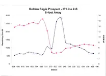
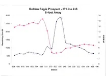
I got some pretty good assays from this "discovery". The assays came from a shallow trench near the peak of this anomaly and showed significant values in gold, silver, copper, lead, zinc and bismuth. I believe this mineralized zone is about 15' wide and plunges about 80' into the ground and could be several hundred feet long. There is an old shaft about 50' west of the anomaly peak. I believe the old timers thought they were onto something, but missed it by about 50'.

This is the data that was plotted from the "discovery" traverse. Notice the chargeability peak value of almost 18 MvS/V (blue line) and also the high resistivity zone immediately to the west of the mineralization occurance.
 

Attachments

  • GoldenEagle-IP2-S-8FootArray.webp
    GoldenEagle-IP2-S-8FootArray.webp
    67.3 KB · Views: 597
  • GoldenEagle-IP2-S-8FootArray.webp
    GoldenEagle-IP2-S-8FootArray.webp
    67.3 KB · Views: 569
I don't understand none of it, is that good?
 

I don't quite grasp the concept either. Your graph appears to react to resistivity of a current in the ground, suggesting something along the lines of a magnetic anomoly, but could be metallic. To me it looks like only 40 feet or so is highly mineralized, but I'm not operating the machinery either. If this is where your gold/silver/platinum/palladium/iridium/rhodium assay came from (and I'd expect that much more in New Mexico or Arizona rather than B.C.) then it looks like you may have a pocket. But the graph only shows one direction.
 

First of all - the assays of the gold / silver / platinum are from a totally different property.
Second of all - the samples that I took (about 1 foot deep into the bedrock) from directly above the induced polarization anomaly (blue line) showed significant amounts of gold, silver, copper, lead, zinc and bismuth.
It is true that this is the only traverse that I have across this zone. By the way, this is only part of the entire traverse which was about 1200 feet in total length. Obviously I need to, and plan to, run additional parallel lines in this area. This will give me an indication of the length and shape of the outline of the mineralized zone. I do not believe that this is a huge deposit; however, I believe that it could contain significant tonnage to warrant development if the values can be established in the zone (best done by drilling).
There is much work to do on this 'prospect'. I have referred to this as a "discovery" geophysical line with some limited surface sampling in the immediate area that looks encouraging. There is also a chance of finding another, and perhaps larger, deposit in the area as this is in an old producing mining district.
As far as a couple of my "high grade" sample assays - they are from an entirely different district and I am contemplating additional work in those areas.
Hope this clears up some things for you.
Jim
 

So at least a pocket of good mineralization, and possibly a lead to an extension? Did I understand this time?
 

Tuberale -
That's the general idea. I've located something 'of interest' and my assays show me what type of minerals are in this zone that the electronic instrument detected. Further work will outline how large this deposit is, it may only be a couple hundred feet in length. If so, I would call it an "ore shoot" with perhaps a couple of hundred thousand tons of contained ore. At that point, installing a small operation with mill might be appropriate. Additionally, I want to explore the area with more geophysical work in hopes of finding a large deposit that I would probably lease to a mining company for development.
Jim
 

I'll share what I learned in a class called Geology for Prospectors that I took, well, a while ago.

Interesting thing that I remember of the class was a case of a prospector who had a low gold-producing area in a lot of hard rock. Gold content not productive at the price at that time, but the lead was large and fairly extensive. By large, I'm talking several miles long and nearly a mile wide.

About this time the prospector read of a proposed dam (here in Oregon we have lots of those) that would require a lot of aggregate. The dam was large enough that it had a 2-lane gravel road up the face of it, allowing rock to be added by the dump-truck load.

The prospector had an idea. After carefully working out his operations costs, he put in a low-bid for the aggregate for the dam. Put the rock through a stamp mill to crush it into fairly uniform size, the slid it down a mercury-coated chute 6-8 feet long and into the waiting dump trucks. Undercut all other bids to provide aggregate. Bid was so low the government agency questioned his ability to provide the rock at that price. He explained his operation, and asked did they want it or not? They took his bid. For every dumptruck of aggregate that went into the dam he lost money. But he made a modest profit from his gold extraction: not much, just enough to make a tiny profit from an otherwise unworkable deposit. On every ton.

Prospector became a millionaire within the first 6 months of operation. Dam construction took over 5 years.

The question arose: was this guy a prospector, entrepreneur, or treasure hunter? None of these and yet all of them. Mostly, he was smart.
 

eureka77 said:
I don't understand none of it, is that good?
I also don't understand it and probably won't the rest of my lifetime. I'll stick with the lower tech, and (likely) the lower cost of metaldetectors. Tnx for the post. TTC
 

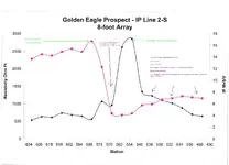
Lets see if I can sauce this out?
 

Attachments

  • GoldenEagle-IP2-S-8FootArray reply.webp
    GoldenEagle-IP2-S-8FootArray reply.webp
    82 KB · Views: 589
Homefire --- you're pretty close on your interpretation of this particular area of interest. The higher resistivity rock is caused by the fact that it is a slightly altered limestone with minor fracturing. The lower resistivity adjacent rock is a highly fractured quartzite. The resistivity values are indicative of the type of rock encountered and the contained moisture content (this can vary due to alteration and/or fracturing). The induced polarization value (chargeability in MvS/V) is indicative of the metallic content of the rock, in most cases sulfide mineralization. I dug a shallow hole at the peak response and noticed iron and copper staining and assayed that sample.
 

Top Member Reactions

Users who are viewing this thread

Back
Top Bottom