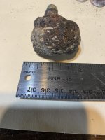
Revisited old three sites, and oe new one that had given up some pretty cool relics, and was rewarded with 8 coppers, five in just two hours of hunting! But today met up Ross Suto... Hope I spelled your last name right... lol. We met up and hiked to a very old field loaded with targets.... but nothing crazy at all until we found this! date on the side 1797. Anyone know about the W 45 O? it was falling over and was being swallowed by mother nature... we propped it back up, and spruced it up a bit, there were orange ties in the saplings around it... we figure the historical society had been there at some point, and detectorist as well, still how cool is that? update thanx to members here I can now say iot is definitely a marke


Last edited:
Upvote
18