Help with possible trail signs along a river

ghost_rider

Jr. Member
Apr 20, 2008
82
6
NOTE: I posted these photos and info on another page but thought I should also post them here for additional comments.

I am somewhat new to the hunting of trial markers and this week while on vacation I did some hiking in a very historic area.

While stomping around I located a unique pile of rocks at the mouth of a cave along the river I was hiking. There are two larger rocks that are about three feet from each other, both having unique and unusual carving. I guess I should note that the cave has a fresh water spring flowing from it, you can't miss it if you are crusing along the river!!!!

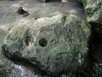
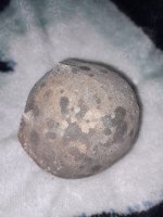
You can see these in the two photos below, the first you will note a large "V" notch carved into the top of the rock with an "M" below and large hole and smaller dimple to the lower left of the notch. The hole may be natural but I am very suspect of the "V" notch as it doesn't seem natural.

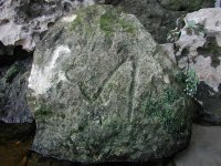
The second photo shows the rock laying three feet from the first photo. This rock appears to may be have some directions with the number 4 below. Looks like an "A" with a half diamond attached to the left tail of the letter.

I was hoping that someone could help me identify and interpret these signs if they are signs. PLEASE NOTE: there are several modern carvings in these rocks as well, these modern carving consist of people's names who have swam in the river at this location..... I identified the name KRIS and other letters that were too worn to read. The marks in the photos are the only ones I suspect to be trail markers.

I will post a wider shot of both rocks if need so that the entire enterance to the cave can be seen along with these two rocks in front.

If additional info needed please let me know.
 

Attachments

  • P1010252-c.JPG
    P1010252-c.JPG
    70.9 KB · Views: 1,233
  • P1010253-c.JPG
    P1010253-c.JPG
    70.9 KB · Views: 1,201
  • P1010252-c.JPG
    P1010252-c.JPG
    70.9 KB · Views: 1,186
  • P1010253-c.JPG
    P1010253-c.JPG
    70.9 KB · Views: 1,181

Timberwolf

Silver Member
Sep 12, 2005
2,528
37
Detector(s) used
Eagle II SL90/Eagle Spectrum/TF-900
GR,

I don't know enough about KGC signs and markers, to help you.
PM me if you really want help, and I will see if I can put you in touch with a couple of people.

TW
 

Old Dog

Gold Member
May 22, 2007
5,860
397
Western Colorado
Rider,
The stone in your second picture looks to have been moved.
Do you have any idea where it was in the first place?

The notch across the stone in the first picture will give you a good compass line to begin with.

I will do some work on the signs carved here and get back on later.
Just to see what I can figure out for you.

Thom
 

OP
OP
G

ghost_rider

Jr. Member
Apr 20, 2008
82
6
Thom.

If the rocks have been moved it seems that they have simply fallen from the ledge above, but it seems odd that it would have landed symbol side up.... there is also a fair amount of swimming and activites in the area, may have simply been moved from one of the many floods!!!!

Any help would be greatly appreciated...... the mention of using the groove as a sight has crossed my thoughts and I think it may point to a small hole in the bank across the river.

Look forward to seeing anyting you might be able to come up with.

THanks,

ghost_rider
 

Treasuredawg

Jr. Member
Mar 19, 2006
53
5
Northern Arkansas
Detector(s) used
Minelab Exployer II, Xterra 30
I have found a rock with a groove in the top but it's more like a tombstone. Is that an "M" below the groove and to the right of the drill hole? "M" could mean mountain....could mean look through the groove for a hole (indicated by drill hole) in the mountain. My understanding though....about drill holes is to place a stick in the drill hole and go in that direction. If you go to the back side of the rock and look through the groove with a stick in the drill hole what do you see in that direction. Also, what are the carvings below the "M"? They may be important as well.

Treasuredawg
 

Treasuredawg

Jr. Member
Mar 19, 2006
53
5
Northern Arkansas
Detector(s) used
Minelab Exployer II, Xterra 30
One thing I forgot to mention...If you have access to a metal detector check all around the rocks for any metal clues that might be buried in the ground. Check out at least 10 feet in all directions. Sometimes they buried metal clues aroung the rock carvings and sometimes not. If you find a metal clue carefully dig down to it and see if it points a direction. If you need to pick up the clue to check the direction indicator do not rotate it as you will lose your direction as they were very precise in placing these clues. Also, check for any bent trees in the area that might point a direction.

Treasuredawg
 

Old Dog

Gold Member
May 22, 2007
5,860
397
Western Colorado
To add a bit.
Gps the metal part
and record both azimuths(+ and -) in a pocket book To get a full compass line.
it will help to get photos as well of every metal clue.

The rock that looks to have been moved is a KGC marker for sure.
I will doodle it in paint shop later but it is a spade (as in a deck of cards)
I will have to do some negative work with the marks.
I'll post again when I have more.
Thom
 

OP
OP
G

ghost_rider

Jr. Member
Apr 20, 2008
82
6
I certainly can say enough for this wonderful help!!!! I have plans to make a trip back up sometime around 4th of July, these are about 2 hours from me near some property I own.

I'm not sure about the mountain indication as there are no mountains around, perhaps a high hill but no mountains.

I'll make sure to print this info and take it with me and I will certainly heed the advice and document, document, document.... photograph, photograph, photograph!!!! I guess you can't record too much and it probably never seem like enough.

I am almost certain there is another hole across the river, almost right across from the large groove if I recall correctly. If you put a stick in the hole it would almost certainly point to the same place that the groove is sighted to acorss the river.

Next visit I plan to spend the better part of the trip in the area, scouting to find what's placed there!!
 

Treasuredawg

Jr. Member
Mar 19, 2006
53
5
Northern Arkansas
Detector(s) used
Minelab Exployer II, Xterra 30
If you find a metal clue....they used the old surveyor measurements....rod, chain, furlong if you don't know these measurements look them up on the Internet. They also used 33....66 etc. 33 is 11 man steps. If you find a metal clue go 11 steps in the way it is pointing and see if there is another clue. I have found many clues like this. If you need more info PM me.

Treasuredawg
 

OP
OP
G

ghost_rider

Jr. Member
Apr 20, 2008
82
6
Could someone please post a photo of a "bent tree" so I know exactly what to look for, maybe Treasuredawg could post one as per our PM conversation. I will hopefully be making a trip to the site the July 4th weekend and I am getting notes and photos prepared to use in the field.

Thanks in advance.
 

Old Dog

Gold Member
May 22, 2007
5,860
397
Western Colorado
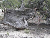
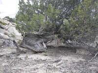
This won't help much as it is about the best example of a bent tree from my area.
It will not corespond well with the type of bent trees you will see where you are.
But it should give you some idea.

Thom
 

Attachments

  • 52408_054-A.jpg
    52408_054-A.jpg
    112.5 KB · Views: 1,122
  • 52408_055-A.jpg
    52408_055-A.jpg
    110.9 KB · Views: 1,117
OP
OP
G

ghost_rider

Jr. Member
Apr 20, 2008
82
6
This looks to be a Cedar Tree..... were certain trees used as the bent tree.... I have read about the use of dog wood trees.

Just a list of example trees would be fine.

Thanks,

ghost_rider
 

Old Dog

Gold Member
May 22, 2007
5,860
397
Western Colorado
You may find
oak
Beech
Pines
Cedar, or Juniper (like mine)
Any long lived trees

these trees may have been bent by Native Americans prior to their use by KGC, but most are on a compass line that is used as a bearing line by KGC..
Here is a link that may help,
http://www.ahgweb.com/images/pamphlet.pdf

The link says Indian trail trees But not all of them are.
The KGC who set up the reserves would even graft the trees to shape them .
But take a look and see if this helps.


Thom
 

S

Smee

Guest
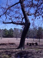
Here is a bent tree I found recently in Union County, Arkansas:

tree.jpg


This type tree may or may not be native american. It would require an examination for certain markings.

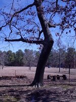
Here is a different type of bent tree, with a graft . . . to form an arrow:

pointer02.jpg

The branch in the crook of the tree is of a different species, and it is noticeable at 90 degrees to the bend in the warm part of the year in the early morning or during winter when the leaves are gone. I mistook this for a trail tree when I was first doing research. Hope this helps.

BTW, Old Dog didn't know, but I wrote the pamphlet he directed you to, and all the trees shown (except the pencil sketch) are ones found in Ashley County, Arkansas.
 

Attachments

  • pointer02.jpg
    pointer02.jpg
    112.2 KB · Views: 1,020

kiddrock33

Hero Member
Jun 14, 2003
688
12
Massachusetts
66 foot diameter circle use drill hole as center. you may locate carvings on that circle. and buried metal objects. to see if this is true start 66 feet due north of this drill hole. detect it ,if there is not a boulder with carving on it , then a buried metal object will be present. usually a broken farm tool, axe, splitting wedge, pitchfork, etc etc. is there other drill holes present . possibly 66 yards apart. or three chains. drill holes possibly in a triangle. that diamond shape attached to the leg of the A is the reason i posted this. that diamond is it lying offset from the leg .if so bob brewer and warren g. book shadow of the sentinal shows a spider webbed map . it contains a line with a diamond attached at a certain angle. if you can check that out see if they are similar. or show me how that diamond and letter A are aligned. you have a very good sign there the M is very good sign. i have seen trees like yours usually they point to caves. besides along trails. any profiles of men ?kiddrock33
 

Top Member Reactions

Users who are viewing this thread

Top