Those are KGC. No doubt about it. I would think there has been a major flood in that area or someone moved one or both stones.. The M has another meaning also.
I wanted to give everyone an update on these possible trail signs along the river, which we have been discussing for a few months now.
I didn't want to leave everyone hanging on the issue!! I have been spending some time in the area but not as much as I would like to. There is certainly something here but there are some added problems that have to be dealt with in the process.
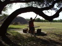
1st- Yes, the area has been flooded and the rocks may have been shifted somewhat or moved from their original positions from the high waters, in fact the last trip was cut short because the river levels were up and covering the rocks. This also makes me suspisious since the rocks are only visible at certain times of the year and unless you know those times you won't find anything!!
2nd- The flooding also adds the issue of some of the trees being uprooted or turned over by the flooding waters, some trees may even be in the bottom of the river now.
I have not yet taken a metal detector to the area but will be doing so in the near future. I have been spending more time checking the other rocks for holes or any carvings, which has proved difficult in itself since there are tons of modern day carvings and names all over the place. I seems that these are the only trail markers in the immediate area and the only carvings that are not associated with someone's name on the rocks.
The next trip we will be working directly with the hole in the rock and metal detecting the area, for some odd reason I feel like we are going to end up on the other side of the river!! This may in fact be the location of the next marker.
I will keep everyone posted and any tips or help is always appreciated here!!!
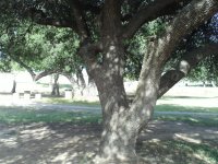
Hi ghost_rider. I am attaching a couple of photos of two trees that are located in Brownwood, Brown County, Texas. One is a Hoot Owl tree and the other is the Eye of the Needle tree. We have many more examples of KGC symbols and signs in our Photos section at:
My problem with "tree markers" is that if someone did that to a tree in its infancy they would not be able to control the growth over the hundred plus years it would take to make it a feasable way to mark a treasure.
You may find
oak
Beech
Pines
Cedar, or Juniper (like mine)
Any long lived trees
these trees may have been bent by Native Americans prior to their use by KGC, but most are on a compass line that is used as a bearing line by KGC..
Here is a link that may help, http://www.ahgweb.com/images/pamphlet.pdf
The link says Indian trail trees But not all of them are.
The KGC who set up the reserves would even graft the trees to shape them .
But take a look and see if this helps.
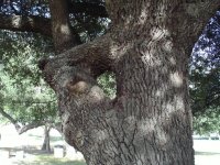
I have seen these trees before,there is one on a home site I am working at.It is near the end of a quartz rock wall,which intersects a feild at 90 degrees.Which way is the tree pointing? from the base bent towards the object of intrest? There is a spring nearby my tree but the tree is bent away from the spring.