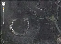
It amazes me to know end how much stuff is being located with sat maps. I have minimal experience with sat maps and identifying arch remains but I noticed a couple things. The photo is taken during a sunny day. That helps with identifying shading, etc. Because of this, it looks like most of the stones or whatever they are are submerged. I thought at first they may be covered with vegetation but their edges are too sharp. So when you go look for this, you will only see the objects that are brilliant white in the photo.
I will also add that the two circles previously mentioned are interesting but not likely for the reasons posted. If you look closely, they are not depressions. They are vegetated with woody plants, exactly like the areas adjacent to the outflow channels (the streams) which should be open water. It would be my guess that the circles are raised humps of soil. That does not necessarily mean they were man-made but worth checking out if the large stone circle is found to be prehistorical.
I agree that the objects making the large circle appear to be stone and not man-made objects like appliances, etc. The "stones" are irregular and have what appear to be irregular (not smooth) sides. If the "stones" are twice the size of a refrigerator, then the displacement of some of them from the circle is also curious. Four reasons I am familiar with could do that- an explosion from within, the collapse of a larger superstructure (like a lighthouse) from above, slumping of the earth on the outside of the blocks causing them to roll, or frost heaving. I doubt frost heaving since they are large and on a relatively level plane. I doubt the superstructure method since you would see more debris. An explosion is a possibility. And the slumping too because I know nothing about the long-term (hundreds or thousands of years) natural forces at work in a marsh or swamp.
There are two other things to consider. IF this is prehistorical, you would be looking at 9,000 years ago plus for a date because during the last major glacial advance the ocean level dropped 400 feet worldwide on average at glacial maximum. I am guessing at about 8-9,000 years ago this area would be wet if not flooded again so the transportation of blocks to the site would be difficult at best. And why would you build on a wet site anyway? I am assuming that your island is relatively flat from the shore to this location. The other thing is where would these blocks come from? They look like limestone to me. So to find a likely source would be helpful in any analysis.
I also am curious about the open area in the circle. There do not appear to be any stones there at all unless they are deeply sunk and buried. That would indicate to me a possibility that the open area was an entrance. No big deal interpreting that little nugget but it does, in turn, indicate something else- that the earth around the base of the stones was the level ground at the time of use. In other words, these were not buried foundation stones. So, if you find there are no more stones underneath these ones, this could not have been any kind of large structure.
I guess no matter what it turns out to be, it is obviously done by humans. So get a feel for the location relative to the larger geographical area and start asking yourself why here? No matter what it was, why would someone build a tower, bunker, artillery placement, solar or lunar observation site, or 7-11 here? Getting an idea of why may help you interpret possibilities for the site. Good luck and have fun!! If you want further assistance, I would be happy to take a look at the GPS coordinates or larger area sat photos and talk with you. I live in Wisconsin so I would not be claim jumping nor do I know anyone down there who could anyway.

 and if you wondering no I wont pin point the location but I will say it is on the S.E. Coast near G.A./S.C.. Thanks for your help.
 and if you wondering no I wont pin point the location but I will say it is on the S.E. Coast near G.A./S.C.. Thanks for your help.


 ? If not, I have no clue. Both will need to have someone go and find out. Especially the one you found.

