Indian maps on rock

Swiftless

Tenderfoot
Joined
Jul 17, 2008
Messages
4
Reaction score
0
Golden Thread
0
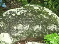
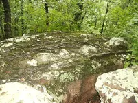
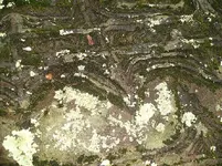
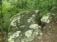
A buddy has this around his property. It has been passed down throughout his family generation to generation and he still doesn't know what to make of it. Asked him if he cared if I asked you folks and he thought it was quite allright. If you can help us out in making it out it would be greatly appreciated.
 

Attachments

  • rock1.webp
    rock1.webp
    149 KB · Views: 499
  • rock2.webp
    rock2.webp
    147 KB · Views: 496
  • rock3.webp
    rock3.webp
    151 KB · Views: 493
  • rock4.webp
    rock4.webp
    162.1 KB · Views: 496
Upvote 0
As you can see, their are lines around the bald rock which leads me to believe this is not erosion. The rock is upon a cliff which part of it has broken off over time. You can see what looks like arrows in a couple different places. A couple native americans came down one yr to look at it and one sit down looking off into space then got up and left w/o speaking a word. Kinda unusual unless it was some sort of sacred "rites of passage" or something. Anyways if you can help would appreciate it!

SW virginia, don't know if he wants to give the direct location as of yet
 

I am not saying that this is, or is not, a geological feature rather than the result of human activity. However, it reminds me of some of the symmetrical boxwork patterns shown in a number of interesting photos at the following webpage:

http://cita.chattanooga.org/messageboard/
 

PBK said:
I am not saying that this is, or is not, a geological feature rather than the result of human activity. However, it reminds me of some of the symmetrical boxwork patterns shown in a number of interesting photos at the following webpage:

http://cita.chattanooga.org/messageboard/

I have seen similar formations (natural) here in Oklahoma. There are some that we call "turtle rocks", that look identical to their namesake. They come in just about every size, from golf ball to 4-wheeler size. It's amazing just how much they look like turtles, with the shell plates and all. Many people still claim they are fossilized turtles and collect them frequently.

PBK - interesting link and I appreciate it. There is some very good reading there and I bookmarked it. I wish I knew more about geology, I guess that comes hand-in-hand with collecting artifacts made of stone. I have been in the progress of putting together a natural weathering and "geofact" reference for quite some time now.
 

Almost looks like a map for a cave! Neat pics thanks for sharing!!! :thumbsup:
 

Since you said SWVA, that almost - well it does actually - look like a topo map of how the ridges, mountains, and valleys run around here.
 

WOW! Most interesting.
 

It looks like a Map Rock to me. It is in 3-D, as a topo map. There is one very high mountain or hill on the end of the rock, use that as a key with a modern topo map of the area you are facing when you look at the rock to unlock what is being said here. I think the lines represent waterflow, the big section of lines is a river, with feeder streams coming in from the small valleys. I don't see any of the treasure marks I am familiar with, and this is probably just a map of the region. The map itself is a treasure! Thanks for sharing this with us.
 

A big thanks to all of you for your replies, didn't expect that much. I hope that it is not the geological feature
that some feel it is and would like to keep on thinking that it is some sort of map. Maybe we';ll find someone to decyper it one day. Thanks
 

Top Member Reactions

Users who are viewing this thread

Back
Top Bottom