Hi All,
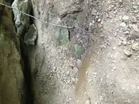
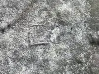
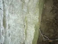
Interesting thread, I sometimes forget how much there has been found in the Caney Creek area. Our old friend Boomer had so many things in that area to check out. Someone asked last year about a carving in the area, just read it...I think they ae referring to the Crane carving. It's located at the junction of Caney and Little Sandy. If you left the Caney boat ramp as soon as you turn left at the little sandy it's on your left. Getting very faded, couldn't have found it without several emails form Boomer. If the revivor is at summer level its almost in the water. As an aside, there is a faded map carving as soon as you leave the Caney boat ramp and pass the big rock on your left (looks like a Buffaloe laying down) not more than 50 yards there is a large flat rock...we used to call it the turtle back rock...it can be slightly under water when the revivor is summer height..on top of it is a map and it has figures carved into it. I had talked to the people at the Falls of the Ohio about getting it protected, but the Army Corps of engineers never returned my call about it...so before its totally gone maybe someone can decipher it. It has hash marks that i presume are paces or if its Spanish maybe Strada, English maybe rods, anyway it has some figures, one looks like an Indian holding a bow...another has what looks like a upside don L the hash marks go past carvings of what i think are hills or hollows, then turns right and goes into a hole. These were pretty plane in the 1980s, but boats and their props are taking a toll on it, as is the up and down of the reservoir level. That acts like sandpaper on the rock.
If anyone has questions about the Indian Waybill just PM me...I have found all of them...there are 6. Wrote a short story about them. Seems Boomers Waybill and the one published in a magazine by Henson are slightly different. The Indian and i must have the same stride as when he gives a number of paces they are exactly right! For those just getting interested you have to keep in mind the Indians references to landmarks are different than ours. I fell in love with that area the first time i visited! I live near Cincinnati so its a good 2 and a half hours to get there, and since the girls are grown i don't get there much, I met Brushy Bandit there and we did some exploring, he is the only one that has found any silver as far as i know. But the aviator/inventor Mathew Bacon Sellers found 13 Spanish silver coins there in the early 1900s.
I have a theory about a the Indian that came from the resettlement in Oklahoma area, he had retrieved a mule load of silver coins from somewhere around the Sandy Hook area and was murdered. He was a nephew of cornstalk if I remember right. He had got a map from the grandson of Blue Jacket. Anyway, it was strange that when the Indian was murdered, a family in that area suddenly left, then almost a generation later some returned with some wealth...Hmmm...the Waybill that Boomer had came from the same family he said an old lady from Florida had got in touch with him and had the waybill. There is more to it but i don't want to embarrass the family.
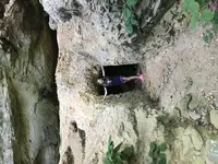
 its the one with the map, almost gone now.