Is there gold on the OTHER side of the mountain?

gold chick

Full Member
Joined
Dec 28, 2019
Messages
106
Reaction score
176
Golden Thread
0
Location
Texas Gulf Coast
Detector(s) used
Garrett AT Pro
Primary Interest:
Metal Detecting
I have a question. I have found a location with multiple lodes on ONE side of the mountain, along with a huge placer discovery at the bottom of the mountain. This side of the mountain is all claimed up.

The other accessible side of the mountain has only two gold claims, lots of land left unclaimed on public property.

What do you think are the odds of finding gold on this other side of the mountain? Is it worth prospecting with a metal detector? Or not?

The X on my map is the general lode locations and the ? is for the area I am considering prospecting.

TIA!
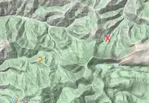
baldy-mountain.webp
 

Upvote 0
Well, why not try?
 

Just watch for the squatch
 

This doesn't answer your question but mineral deposits are usually associated with fault zones and faulting is the source of many or most of the earth's mountains. https://www.google.com/search?q=MIN...ome..69i57.21415j1j7&sourceid=chrome&ie=UTF-8.

As an anecdotal offering: My side of a local mountain range has virtually no metal mineral deposits while the other side has a massive copper deposit at it's base as well as several other lesser metal mineral deposits nearby including gold.
 

Last edited:
I’d suggest checking out the geological maps for that area. Also look for signs of placer mining further down the drainage.
 

No personal experience with this. However, in your place, I’d get ahold of a topological map of the area and annotate map showing locations of known load gold sources. From those points, I’d trace down areas with the steepest gradient to some lowest point where gold might have a chance to collect. Additionally, I’d look for paths down from lode sources to ground looking for plateaus where gold might get caught.

I believe that areas on land where gold collects without ever hitting streams are termed eluvial deposits. For example, could be a ridge on side of mountain under load source. Gold concentrated via the movement of water is alluvial. So, I’d be inclined to look for both.

WRT load gold, I’d probably note rock type and specific features such as contact zones where load sources are known to exist. Then I’d look for same elsewhere.

Hell, this sounds really frickin’ fun. Wish I lived west of the Mississippi.
 

Last edited:
I'd look closely at the geology of the gold area. Then I'd walk the other side of the mountain, giving a quick scan looking for similar geology. If found, I'd then spend some time there with the detector.
Jim
 

Anywhere in the lower 48 states you can have quick access to all the geologic maps for any area. It's all there in the Land Matters Geology Maps. Thousands of maps ready for download with a few clicks on the map.

Go to the Land Matters Geology map page. Select the state you are researching in from the list on the right. When the map opens zoom in to your area by clicking and dragging a box around the area you want to study.

Then
  • Click on the "i" tool on the right of the map.
  • Click on your area of interest.
  • In the window that pops up will be an row named National Geologic Map Database Query. Click on the link that says Click for Map List.
  • A new page will open with dozens of links to bedrock studies and geology.
  • Read, study and enjoy.
:thumbsup:

Heavy Pans
 

Last edited:
Barry , as you know My Land matter's is far superior to ANYTHING that is available . I (in my younger years) collected over 400 topo maps from around the U.S.A. by one means or another . After wearing out my ole body I started to want to share what I had learned and my equipment with club member's . I had no use for all these topo maps anymore because I couldn't get out much. SOOO I contacted clubs from all over and wanted to donate the topo's for their state to them BUT they turned my offer down saying they get this info on their smart phone's .........I even offered to donate my maps & books to our library and they turned me down also... Now me not needing them I put them into the trash . Your site is the best thing that any prospector / miner could ask for along with your expert advice ! A SALUTE to you !
 

No personal experience with this. However, in your place, I’d get ahold of a topological map of the area and annotate map showing locations of known load gold sources. From those points, I’d trace down areas with the steepest gradient to some lowest point where gold might have a chance to collect. Additionally, I’d look for paths down from lode sources to ground looking for plateaus where gold might get caught.

I believe that areas on land where gold collects without ever hitting streams are termed eluvial deposits. For example, could be a ridge on side of mountain under load source. Gold concentrated via the movement of water is alluvial. So, I’d be inclined to look for both.

WRT load gold, I’d probably note rock type and specific features such as contact zones where load sources are known to exist. Then I’d look for same elsewhere.

Hell, this sounds really frickin’ fun. Wish I lived west of the Mississippi.

Oh, it's so fun to nerd out to. Thanks for the tips, that is all great advice! From what I have found, all the obvious spots around lodes are claimed, but I think using some deductive reasoning there is still lots to be found and unclaimed. Can't wait for this summer!
 

Barry , as you know My Land matter's is far superior to ANYTHING that is available . I (in my younger years) collected over 400 topo maps from around the U.S.A. by one means or another . After wearing out my ole body I started to want to share what I had learned and my equipment with club member's . I had no use for all these topo maps anymore because I couldn't get out much. SOOO I contacted clubs from all over and wanted to donate the topo's for their state to them BUT they turned my offer down saying they get this info on their smart phone's .........I even offered to donate my maps & books to our library and they turned me down also... Now me not needing them I put them into the trash . Your site is the best thing that any prospector / miner could ask for along with your expert advice ! A SALUTE to you !

I will ABSOLUTELY take your maps!!! I cannot believe that people discredit the importance of PRINT MAPS! Man, what if the grid were to go down and we lost access to digital maps. They would be more valuable than gold, actually invaluable! Libraries would be raided for maps!

Not that I am a doomsdayer or anything ;) just like to be prepared
 

Anywhere in the lower 48 states you can have quick access to all the geologic maps for any area. It's all there in the Land Matters Geology Maps. Thousands of maps ready for download with a few clicks on the map.

Go to the Land Matters Geology map page. Select the state you are researching in from the list on the right. When the map opens zoom in to your area by clicking and dragging a box around the area you want to study.

Then
  • Click on the "i" tool on the right of the map.
  • Click on your area of interest.
  • In the window that pops up will be an row named National Geologic Map Database Query. Click on the link that says Click for Map List.
  • A new page will open with dozens of links to bedrock studies and geology.
  • Read, study and enjoy.
:thumbsup:

Heavy Pans

I use Land Matters for searching active claims, but I didn't realize it had links to maps! I will most definitely be using that feature! Thanks for the tip! :occasion14:
 

Maps are great, but tend to show large geologic areas. You may be trying to find a small outcrop of valuable minerals that would not show on the maps. Sometimes you must put "boots on the ground" to really know what's going on.
Jim
 

I will ABSOLUTELY take your maps!!! I cannot believe that people discredit the importance of PRINT MAPS! Man, what if the grid were to go down and we lost access to digital maps. They would be more valuable than gold, actually invaluable! Libraries would be raided for maps!

Not that I am a doomsdayer or anything ;) just like to be prepared


You are one of those intelligent ones.....not many people who can think that far in advance any more haha(I still keep an 50 state atlas in my truck)
 

I use landmatters but it's hard to use on an android phone and my signal sucks here.

I like your off grid living website. We've been off grid for 10+ years now and still learning! It's been an awesome life change tho.
 

Just remember that the claim location map on Land
Matters shows a partition of ground that has a claim within it...an important distinction is that the entire area shaded in not necessarily claimed. You have to go to the County Recorders office and view their claim location notice to determine the actual limits of the claims. It’s just a tool to get you started.
 

Gold Chick, you might want to check out your state's Division of Geology, or whatever it might be called. They will have access to maps AND historic publications on geology and minerals throughout the state.
 

Gold Chick, you might want to check out your state's Division of Geology, or whatever it might be called. They will have access to maps AND historic publications on geology and minerals throughout the state.
 

As an interesting bit of trivia....Your mountain is less than 50 miles from Confederate gulch and the Montana Bar, the location of the richest gold discover in Montana. Individual pans showed values of over $1000 each
 

Top Member Reactions

Users who are viewing this thread

Back
Top Bottom