Jupiter Inlet Florida

  • Thread starter Thread starter Cappy Z.
  • Start date Start date
C

Cappy Z.

Guest
You know, alot of folks talk about Sebastian and Wabasso but me thinks Jupiter Beach is the hottest treasure beach to look. There have been coins from 1600's found there, and of course many other dates some that would include the 1715 Plate fleet. But if one looks at a largermap more inclusive of the Bahamas....the west End of the Bahamas is almost directly across from Jupiter. Now if I was a swashbuckling pirate and me crew were hitting English, French and Spanish ships...what a perfect hideout in the inlet? I bet that area is loaded with artifacts just waiting for the picking. I'd bet my last doubloon there are a handful of TNers down there that know a whole heck of a lot more.

:icon_pirat:
 
Upvote 0
lol an I bet alot more arent talkin
 
Hey Buddy,

I have been detecting that area and have yet to find my treasure. Your are right about the 1715 fleet and I am sure you have all heard about them renourishing the beach and hitting one of the ships and they were pumping coins and treasure right onto the beach. That was before I became obsessed with this hobby, and I have only read about what was found. I detect that area weekly and like I said have yet to find my gold, however just being at the beach is a blessing, any thing I find is icing on the cake.
 
It's unlikely Jupiter Inlet was in its present location in 1715. It's only been navigable in recent years since it was stabilized. Same with St. Lucie/Stuart and Ft. Pierce.
 
billinstuart said:
It's unlikely Jupiter Inlet was in its present location in 1715. It's only been navigable in recent years since it was stabilized. Same with St. Lucie/Stuart and Ft. Pierce.

Could you, would you elaborate? I'd like to hear more, sir.
 
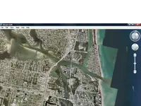
I have done a lot of research on this topic. Prior to the early 20th century, the mouth of Jupiter inlet was approximately 1200 feet south of where it is today. If you are familair with the area, the former inlet was about where the Ocean Trail condos are today.

Jupiter Inlet was well known by the Spanish and shows up on charts as early as the late 1500's. Juan Ponce de Leon cruised the eastern shore of florida in 1513, putting in at Jupiter Inlet to gather firewood and naming the Loxahatchee River "La Cruz" (The Cross).

We know from Jonathan Dickinson's journal of 1696 that the inlet was open at that time.

Tom
 
mad4wrecks said:
I have done a lot of research on this topic. Prior to the early 20th century, the mouth of Jupiter inlet was approximately 1200 feet south of where it is today. If you are familair with the area, the former inlet was about where the civic center is now, at the north end of Carlin Park.

Jupiter Inlet was well known by the Spanish and shows up on charts as early as the late 1500's. Juan Ponce de Leon cruised the eastern shore of florida in 1513, putting in at Jupiter Inlet to gather firewood and naming the Loxahatchee River "La Cruz" (The Cross).

We know from Jonathan Dickinson's journal of 1696 that the inlet was open at that time.

Tom

Hmm? One says north the other south?
 
I agree with mad4wrecks on this. He did his homework. The current salvage lease holders also told me that the original inlet was further south.
 
Indian River lagoon inlets have been very unstable over the centuries. for a while there was an inlet at Vero. There never was an inlet at Sebastian or Cocoa Beach.Further north, Ponce inlet has been there for a long time. The only natural inlet on the east coast is Matanzas. All the inlets were similar to this..not real deep with shifting sandbars and poorly defined channels.
 
I have never seen any information about the Jupiter Inlet being a mile north of its present location but it's possible I guess. The historical documentation was pretty clear to me. And while I never came across anything about 3 inlets at Jupiter, there are three branches of the Loxahatchee river.

Although the current inlet has been dredged, it and the former southern location are due to the natural flow of the Loxahatchee river. Take a look at a map and you will see that. It would be hard to fathom the river taking a sharp turn to the north to empty into the ocean.

The red line marks the path of the old inlet.

The large indian mound that still exists at DuBois park is where Jonathan Dickinson was held captive by the Jece indians and the inlet was to the south of that mound/village in 1696.


A last note, Mel didn't have a problem finding the Atocha because of map errors, but rather because of a translation error on a document where east (este) was mistaken for west (oeste).

Tom
 

Attachments

  • jupiter inlet.webp
    jupiter inlet.webp
    113.9 KB · Views: 895
yes that simple error oeste (west) vs este (east)--- cost mel fisher lots of money and many years of hunting in vain -- and who was doing this bit of translating of info for mel fisher ? -- and also seeking their own fortune as well as fame ? --- another key clue was when they understood that the key named after the 1st salvor that had earlier done salvage was the "proper" starting point --not half way up the chain of the keys as "the translator" had said in error. -- was it (a) a couple of honest mistakes or was "the translator " (B) steering them the wrong way while gathering info for his own "private" search -- for the atocha later on -- some say A others B .

thats why I wonder when reading --is the following wording from admiral salmons letters translated correctly --- (A) "wreckage was found on the north coast of st augustine "--- when it might in fact correctly be read (B) " wreckage was found on the coast north of st augustine" ---one way (A) means along the north coast of st augustine proper.--the other way (B) means much farther north


the 15 leagues to the leeward "remark" that was also translated makes me think - about 39 miles "northward" ---so the spanish report by salmon and spotswood letters seem to "jive" since spotswood's letter says "about 40 miles" northward of st augustine there is a shipwreck .
 
trust me these guys know all about where the actual inlets were during the 1715 ish aera --they been doing their "homework" for quite some time now -- the current inlets spots by and large are not the same spots ---except for matanszas
 
You have me intrigued. Please spill the soup..my way. I am fascinated.

I have invented a new MD that can pin point.....never mind.

I need a true treasure beach..

:icon_pirat:
 
ivan salis said:
trust me these guys know all about where the actual inlets were during the 1715 ish aera --they been doing their "homework" for quite some time now -- the current inlets spots by and large are not the same spots ---except for matanszas

Ivan, you do know that the current inlet for Matanzas is further south than when the Fort Matanzas was manned by the Spanish? The old inlet was approximately where the current access ramp is currently.
 
matanzas is a bit differant but roughly the same --others are way differant --yes (at the st augustine lighthouse) there is a interactive display the shows how the st augustine inlet has changed over the last about 300 years or so -- while I'm not a fan of LAMP -- mainly due to their anti ship wreck salvager mind set --the display is nice one.
 
I don't want to hijack the thread from the OP and the topic of Jupiter Inlet, but Mad4Wrecks posted the informative links above. Ivan mentioned an interactive display at the lightstation on Anastasia Island. For those that are interested: http://www.staugustinelighthouse.com/coastline.php

I would love to drag a PI blanket on the north end of the state park.
 

Users who are viewing this thread

Back
Top Bottom