elthesalmon
Jr. Member
- #1
Thread Owner
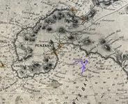
One of my cartography collections this's an interesting antique working hydrographic map/chart of English Channel. Printed on very large paper in late 19c. See section picture below there're pencil marks hand-written by its former owner(s). Not cargo shipping plan or route, private sounding recorrection surveys possibly not confirmed.

 ) leaving clusters of shadowed inland terrains, although systematic hachuring method begun dating back to late 18c, not widely used in later 50-100yrs by cartigraphers and plate engravers. thus "terrain shadows" were profiles, artistry rather than practicality at that time.