What's new

Kidd-Palmer Treasure Maps SOLVED by Oliver D. Smith

The hoaxers revealed...

View attachment 2263921


I went through the Wilkins-Hedden correspondence again and have found something very interesting -

Hedden and Wilkins both stated that when they examined the Skeleton Map in Palmer's possession, it had "Death Valley" written on it but Wilkins further stated that the Skeleton Map had "Europa Point" written on it. However, the reproductions of the Skeleton Map found in Furneaux (1972), Edmunds (1996), Bath (2013) and on the internet do not show either "Death Valley" ("Valley of Death") or "Europa Point" on the map. Hedden noted that some of the text on the original Skeleton Map map including "Death Valley" was poorly legible. Note "Europa Point" is on the Rainbow Island map. So what does this mean? When Hedden/Wilkins saw the original Skeleton Map it had two more place names from the Rainbow Island map but those did not appear on later map reproductions.

View attachment 2263915
Europa Point on the Rainbow Island Map (1903)

View attachment 2263918
Reproduction of the Skeleton Map without "Europa Point"

Here is the relevant snippet of text from Wilkins' (1937) letter that mentions Europa Point:
:
View attachment 2263920
View attachment 2263919

This is further evidence that Gjb was it making up that Wilkins knew of Rainbow Island. Wilkins did not say he knew about "Death Valley" and "Europa Point" from the RI map but only the Skeleton Map = "P's chart" (Palmer's chart); in the same letter he makes clear that by P's chart he meant Palmer's since he was discussing "Palmer's vellum key chart". If Wilkins had known about the RI map he surely would have mentioned it during correspondence when he mentioned Europa Point (and Death Valley). As more evidence, Gjb was not telling the truth, note how Wilkins was trying to match Europa Point and Death Valley to places (like a swamp) on Oak Island; this would be completely pointless if he knew those place names were from Tracy's fictional map of Rainbow Island. It is clear from the correspondence that he had no knowledge of the RI map which was the actual source where Europa Point and Death Valley were copied from. There are two possible explanations why "Europa Point / Death Valley" were omitted from later reproductions of the Skeleton Map:
  • Those annotations were barely legible and fading so by accident were omitted from reproductions of the maps.
  • Hubert (and Guy) Palmer were the hoaxers who omitted them because they knew they were too plot-specific to Tracy's novel and realised their mistake by including those places names on the original map. In Tracy's book Europa Point is the name that Robert Jenks gives to the western extremity of the island.
Over the past two months, I have found a lot of evidence that Hubert and Guy Palmer were the hoaxers and (2) is more probable than (1). In fact, I now have near-proof that Hubert Palmer was responsible for the writing on the Skeleton Map border. I was going to wait to show this and unmask the hoaxers in the monograph I am writing, but might as well now since Crow mentioned about comparing handwriting from the Skeleton Map. Last year, I managed to get a scan/photo of a letter written by Arthur Hill-Cutler (see here). I then intended to pay an expert to examine Cutler's writing, compare it to the writing on the borders of the Skeleton Map and publish a graphological report. I further managed to obtain Hubert Palmer's handwriting from two letters Gjb posted on his website, as well as Harold T. Wilkins' handwriting from correspondence he had with various book/magazine publishers. So I have Palmer's, Cutler's, and Wilkins handwriting (and signatures) to compare to the writing on the Skeleton Map. It was not until the last few weeks I contacted an expert, but they were going to charge me around £300 to make the report. I then realised that the expert was not needed since (1) it is clear out of the three who made the writing on the Skeleton Map and (2) there is free sophisticated software online that can easily compare the handwriting. All the software I have used determined with very high probability (>95%) that Hubert Palmer wrote the text on the Skeleton Map but Cutler/Wilkins came back very low probability (<5%), in the case of Wilkins virtually nil (George Edmunds who claimed Wilkins was the hoaxer is again proven to be clueless).

Some things to look out for:
  • Letter 'f': in both letters of Palmer (see below) and the map, lowercase 'f's feature a tall upper loop paired with a long, straight descender extending well below the baseline (visible in "feet" at the bottom right of the map and words like "for", "find", "fourth", and "forlorn" in the letters). In the second letter his exact same stroke is visible throughout, particularly in the bottom lines in words like "cliff," "left," and the crossed-out word "feet" (just before "Ft deep").
  • Capital 'R': the capital 'R' in "Rocks" at the bottom of the map shares the exact formation, upper loop curvature, and rightward kick leg seen in "Sir R. Hall" and "Ridd" in one of the letters.
  • Lowercase 'r' and 'e': the soft arc of lowercase 'r's and small, fluid 'e's (seen in "centre" on the map margin) match the rhythmic strokes in words like "letter", "written", and "there" throughout the letters.
  • Slant and Flow: both samples exhibit a consistent rightward slant, light-to-medium line weight, loose letter joining.
  • The Letter 'b': on the map the 'b' in "beach" has a soft, rounded bottom curve that leads smoothly into the next vowel. In the second letter: look at the word "back" (in the phrase "At back of the Cave" on the final line). The entry stroke, loop, and base of the 'b' are identical to the map's "beach."
  • Number Formation: on the map '5' in "55 feet" has a distinct, somewhat disconnected top bar and a sweeping lower curve and in the second letter the 5 (middle of the page) and "5th" (bottom line) shares this exact same disjointed top stroke.
View attachment 2263922
View attachment 2263923View attachment 2263925
Unlike certain forum members, I had sense not to rule out Hubert Palmer (and his brother Guy Palmer) as being the hoaxers. Last year, I suggested that the Palmer brothers' could have been involved with Cutler, in fact in some comments I hinted Hubert Palmer was possibly involved in the map forgeries, but I received ridicule and abuse from certain forum members who now have egg on their faces. As far back as July last year, Randawg72 even questioned me for daring to suggest in the slightest that Hubert Palmer was involved in the hoax:


So I was right to not rule out Palmer as the hoaxer. George Edmunds instead categorically denied that Hubert Palmer was the hoaxer. How wrong (again) was he. In fact, even Gjb got it completely wrong and instead in his 2023 book argued that Palmer had been "duped" (like Randawg72 argued) and was innocent. What is astonishing is Gjb could have compared handwriting from Palmer's letters to the Skeleton Map on his own website but he never did. He could have known who the hoaxer was decades ago. Why did he not bother? Mindboggling.
Thx for posting the high res letters which makes handwriting comparison possible. It certainly looks very similar but it could also be someone else in the family as often their handwriting is the same or close.

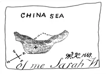
Next issue is that we would really need verified photos of the original maps - the reproductions we have can have a different handwriting (Palmers?) as the originals were faded. Which brings me to the two Sarah maps:
PK3ax.webp

This one is clearly from a different hand
PK3x.webp

while this one (reproduction?) has the typical slant - see 'E' in SEA

Those two Sarah maps seem to me the key to the issue.
 
Thx for posting the high res letters which makes handwriting comparison possible. It certainly looks very similar but it could also be someone else in the family as often their handwriting is the same or close.

Next issue is that we would really need verified photos of the original maps - the reproductions we have can have a different handwriting (Palmers?) as the originals were faded. Which brings me to the two Sarah maps:
View attachment 2264044
This one is clearly from a different hand
View attachment 2264045
while this one (reproduction?) has the typical slant - see 'E' in SEA

Those two Sarah maps seem to me the key to the issue.
Funny you should say that.

I and my brother have the same initials and almost have exact signatures. One of the properties I bought, I was working overseas in South America, and documents needed to be signed; I got my brother to sign them on my behalf. A few years later, I signed a signature for the purchase of a property my brother bought while he was working in the Philippines.

No one knew.

As for Sarah Maps, both have fake wk signatures. People had back in Palmer's time, and later book authors had ulterior motives in promoting the myth.
 
Some good and bad news. The British Library (BL) emailed me a scan of pages from Rainbow Island (1903) [first edition] including the map. I was going to wait a few months until posting this here since I was taking a forum break but the bad news is the BL are preventing me from doing this unless I pay them more money:

1789401019727.webp


This makes no sense and I have fairly good knowledge of copyright law. Tracy's book Rainbow Island (1903) is in the public domain in the UK and the US (and most, if not all, other countries). In the UK, copyright for literary (and artistic) works lasts for the life of the author plus 70 years. Tracy died in 1928 meaning the copyright expired in 1998 and the book (its text) has since been in the public domain. Rainbow Island features illustrations by Fred Pegram who died in 1937, meaning the copyright on his illustrations expired in the UK in 2007. In other words, all copyright terms have lapsed meaning the text and illustrations are completely free of copyright restrictions in the UK. As for the US, any artwork/illustration and literary work published in the US prior to 1931 is automatically in the public domain so Rainbow Island, published in the US as Wings of the Morning does not have any copyright restrictions.

As for reproductions of artwork/images/photographs or copying of text, UK copyright law requires "originality" for a new copyright to exist—the work must be the author's own "intellectual creation". The UK Intellectual Property Office (IPO) has explicitly stated that simply making a digital reproduction of an older image or photo does not qualify as a new copyright because the person scanning it is not changing anything or making any new creative choices. The purpose of a scan is an exact or faithful copy of the original, which inherently lacks creative originality since there is verbatim copying or reproductions are the same to originals. For example, the IPO notes on their website:

Given this criterion, it seems unlikely that what is merely a retouched, digitised image of an older work can be considered as ‘original’. This is because there will generally be minimal scope for a creator to exercise free and creative choices if their aim is simply to make a faithful reproduction of an existing work.

The BL therefore has no legal basis to claim that their digital scans of pages from Rainbow Island are copyrighted. I asked a legal expert and they said their argument concerning copyright was "legally very weak". However, if you read their small print they instead make clear that they will be able to sue you for breach of contract if you upload one of their scans without their permission even if the scan is of text/image in the public domain. When you pay for their services for a digital scan (like I did) you sign an agreement meaning you enter into a legally binding contract—agreeing not to reproduce or commercialize the scan without their permission. To require permission means additional costs: you have to pay a sum to the Permissions Department.

As I mentioned in an earlier comment:
I have now submitted a request to the British Library for a digital scan of the first twenty pages of the first edition of Rainbow Island (1903) including the title page, and the RI map. It cost me £15.25 for the first page and £0.58 pence for each subsequent page. It is going to take at least eight weeks to process - I will post the relevant pages here in two to four months.

Weeks back, the BL got in contact with me to charge me even more money for the scan of the twenty pages (£31.52):

1789405891253.webp


Suffice to say, I have a very low opinion of the BL's service. They overprice the scans and then on top of this want you to pay more money if you want to post the scans on the internet or publish them elsewhere despite the scans I paid for are pages of a book in the public domain and the copyright has expired. It appears they wanted me to pay them at least £15 for their permission. No thanks. To summarise: the BL's digital scans for books in the public domain have absolutely zero copyright protection and their claim they retain the copyright is highly misleading, however, they sneakily (small print) can sue you for breach of contract if you reproduce images of their scans without permission (they charge you). The British Library is basically using their physical ownership of Rainbow Island (1903) to impose greedy contractual rules on any digital scans they generate as a way so they can charge people more money, effectively bypassing the fact that the book is in the public domain. It is quite frankly ridiculous they were charging me over £45 to post a few pages from a book in the public domain. I am not paying the extra £15 for permission to post the scans here.

The good news is I can share the link the British Library provided for anyone to access/download the ~20 pages:


I do not think this is a problem since I am not reproducing the actual page scans but merely linking to them.

1789406310802.webp

Please note: the link expires in 4 weeks. I came back here now to share this because if I waited it would have expired. In good faith, I am sharing this link and now anyone can access/download the relevant pages from the first edition of Rainbow Island including the map. However, for obvious reasons I would ask you do not post the page scans in this thread, or anywhere else, for that matter.

Although I am prevented from posting any of the page scans of Rainbow Island from BL here, note one of the pages has a British Museum stamp on it (view the link); this is proof of when the book entered the institution: "British Museum 3 OC 1903" (= 3 October 1903). The reason for the British Museum stamp is there was no national library in the UK (as a separate institution) until 1973. There was previously a Department of Printed Books, that served as a library and archive of books, inside the British Museum. The British Library was created and the Department of Printed Books separated from the British Museum (becoming the British Library) after the British Library Act 1972 that took effect on 1 July 1973. The fact one of the pages of Rainbow Island was stamped 3 OC 1903 by the British Museum means this is the exact day, month and year the physical book was received, cataloged and accessioned into the British Museum's Department of Printed Books. Although the first edition does not have a print/publication year on it, we now know the book (with the map of Rainbow Island by Fred Pegram) is as old as 3 October 1903 and Randawg72 has been disproven. I predict Randawg72 is going to now argue that the stamp was put on the book decades later and 3 October 1903 was not the accession date. Aside from being improbable to the extreme, the British Museum's Department of Printed Books (which became the British Library) has catalogue cards and other documentation (such as an accession register). There is no doubt 3 October 1903 is when the physical copy was received by the British Museum.

As further proof that 3 October 1903 was the date when the book (which contains the Rainbow Island map) entered the British Museum, under section 6 of the Copyright Act 1842, a copy of every new published book (including new editions with significant alterations) must be deposited to the British Museum's Department of Printed Books, within one month of publication if published in London (three months for the rest of the UK). Rainbow Island (1903) was published by Ward, Lock & Co., in London. The one-month deposit deadline matches the September 1903 publication date: the book first hit bookstores and was made for sale to the public in mid-September 1903. It was formally announced in the "Books of the Week" section of The Illustrated London News on 19 September 1903 and was reviewed by The Spectator the following week on 26 September 1903. Based on these dates, the book was most likely printed in August/early September 1903.

The Map
If you view the link I provided you will have access to the Rainbow Island map (drawn by Fred Pegram) from the first edition (1903) of Rainbow Island. There are a few minor differences, when compared to some maps in the reprints. The most noticeable of these are two or three small dots that look like a ÷ (division sign) after a scribble/tilde (~) after the text "Plan of the Island" at bottom of map inside a border. I am prevented from posting BL's scan of this but in the 1910 reprint (I myself scanned and uploaded) this is visible but more faint. I have used software to lighten the text and the squiggles/tilde after the word "Island". A close up:

1789416674069.webp


This is remarkably similar to BL's scan and is the closest I can post to show you of what the original looks like (to see the original view the link before it expires). You can see what looks like a division sign at the end of the scribble/tilde or rather dots. Of course, this is not meant to be an actual division sign. At first, I thought it was a printing error or random scribbles. However, I have now managed to find out what this scribble or tilde-looking thing is—Pitman shorthand. I was unfamiliar with this but asked someone I know who was familiar with it. They were easily able to translate: the shorthand symbols after "Plan of the Island" spell out "and map" (or phonetically n-m-a-p).

Pitman shorthand breakdown:
  • n (Wave/Horizontal Curve): The first shallow horizontal wave stroke represents the letter sound n (often serving as shortform/grammalogue for "and" or the sound "n").
  • m (Horizontal Curve): The second curve stroke forms the m sound.
  • p (Downward Slanting Stroke): The final straight downward slanting line represents the hard p sound.
  • Dot: Placed beside the stroke, the dot acts as the first-position vowel sign for the short "a" sound (æ).
Together, the strokes phonetically read "n - m - a - p", translating as: "[Plan of the Island] and map."

This makes sense so we now know that those scribbles mean something:

"Plan of the island and map."

1789417323459.webp


In light of this, I think Pitman shorthand should now be applied to the Skeleton Map.

Edit: the person who is familiar with Pitman shorthand I spoke to also stated that the strokes might phonetically read n - m - d (opposed to n - m - a - p), however, they thought this was less likely, but if this is instead the correct reading:
  • The two horizontal waves represent the n and m sounds, followed by the downward stroke for d.
  • The upper dot represents the short u / a sound (un-), while the lower dot indicates the second vowel (-named).
  • Phonetically, this spells "un-nam-d" (unnamed).
This would mean: "Plan of Island (unnamed)." Note that the context of the map in the fictional story (alongside the sketch) is Robert Jenks drew it when he was aboard the ship (before he was washed ashore on the island) so there is no contradiction here; the island was unnamed before he and the female protagonist (Iris) named it Rainbow Island.
 
Last edited:
I have had beef with the British library for years. They promote key ethics of the library and information science center on equitable access, intellectual freedom, privacy, and professional neutrality. They are the worst institution to deal with. And a few other institutions in the UK with the pay-per-view system that designed to milk money. This ultimately gets too expensive for independent researchers to scan through hundreds of documents. For an institution, a library is to provide preservation of knowledge through books and literature; they are not geared for private nor indiviual use but for commercial or institution-backed researchers.

Crow
 
Whether the Palmers were involved in the hoax is a matter of speculation. It seems that, at the very least, Hubert Palmer thought the maps to be genuine. If Guy was involved, it's more likely he teamed up with Cutler to pull a practical joke. But then the joke was never revealed and, instead, the hoax continued for a few more years. To me, that more likely points the finger to Cutler, who was known to be a rather, er, devious antiques dealer. Besides, the maps are very simplistic drawings; they would not require the skills of an artist to create, practically anyone could do it.

On the matter of handwriting, I don't find there's enough of it on the map to make a reasonable analysis. My mother has a distinctive handwriting style, I can immediately recognize things she wrote. But I have also seen writings by others of her generation that are remarkably similar, almost identical. Usually only differing in very subtle ways.
Prior to corresponding with and meeting Harold T. Wilkins in 1932, Hubert Palmer wrote letters* to Charles B. Driscoll (1930). One or two of Palmer's letters to Driscoll were quoted and paraphrased by him in an article "Captain Kidd's Treasure" (The Lincoln Star, 4 July 1930; also printed in The Pittsburgh Press, 6 July 1930 [read here]). Palmer made clear to Driscoll that he purchased the so-called Hardy Chest (with one of the maps inside) from Pamela Hardy: "Miss Hardy, when past 80 years of age, sold the chest to her follow townsman, Mr. Palmer".

1789426516709.webp


Note specifically that Palmer did not state to Driscoll he bought the chest from an antique shop or an antique dealer, rather, that he had purchased it from Pamela Hardy. Now, if you compare this to Wilkins' Captain Kidd and His Skeleton Island (1935, p. 316):

1789427250394.webp

So five years later, Palmer had changed details of his story about how he came to acquire the chest. He told Wilkins that Hardy sold the chest to an antique dealer (Hill-Cutler) and it "made its appearance in an antique shop". None of this was mentioned to Driscoll. On the contrary, Driscoll states (based on what Palmer told him) that Hardy sold the chest to Palmer (there was no intermediary or mention of an antique shop). Someone might argue Palmer by accident forgot to mention Cutler but a Christies' auction catalogue dated 10 May 1932 (written days earlier), states Palmer bought a lot of Lord Nelson relics from Miss Pamela Hardy.

1789428336276.webp

At the time of this auction (10 May 1932), Palmer had not yet corresponded with or met Wilkins. He first wrote a letter to Wilkins later that same month, and a week later met him in person (based on correspondence Gjb has published) although I do not yet have the specific dates. However, note again how Palmer before he corresponded with Wilkins was saying he had purchased directly from Pamela Hardy. He did not tell the auctioneer he purchased the lot of Nelson relics (with fabricated Hardy provenance) from an antique dealer but Pamela Hardy. I understand your scepticism that the Palmer brothers were the hoaxer masterminds but at the very least you would have to admit, the changing narrative regarding the acquisition of the Hardy chest (and Nelson relics) is suspicious. To me, it is strong evidence that Hubert Palmer was the hoaxer since this plausible deniability is a classic tactic used by forgers of antiquities:
  • If Palmer claimed to have bought the chest directly from a woman who did not actually exist (Pamela Hardy never did, at least there is not a shred of evidence for her existence), he is caught in an undeniable lie and becomes the obvious architect of the hoax. However, by inserting Arthur Hill-Cutler into the narrative, Palmer creates a firewall. If the maps were exposed as a hoax and the Hardy provenance as a fabrication, Palmer could simply claim he was the innocent victim of a deceitful antique dealer.
  • With Cutler in the middle, many investigators looking into Pamela Hardy would not be questioning Palmer's honesty; rather they would be focusing on questioning Cutler's records and sources. This muddies the waters and shifts the blame to protect Palmer.
Also, by 1935, as Wilkins was preparing to publish a book that would subject the maps to intense public scrutiny (note the book was published in both the UK and the US [the latter was a revised edition in 1937]), Palmer likely would have realised vulnerability of his original story and therefore inserted the antique dealer. Furthermore, during his correspondence with Wilkins, Palmer came up with other defences: he told him that Cutler "has a flair for what is genuine in pirate relics—and for what is spurious!". This acted as a double-layered defense: not only did Palmer not buy it directly from the phantom Miss Hardy, but the guy he did buy it from her was an "expert" who vouched for its authenticity. If the whole thing was exposed as a hoax, Palmer could pretend to be the victim. To sum up, I believe that Palmer knew exactly what he was doing and was actively covering his tracks as the hoaxer when the story (of the maps) gained traction and publicity. Cutler and the Palmer brothers were complicit together and involved in the Kidd-Palmer map hoax, but my viewpoint now is that the Palmer brothers were the mastermind forgers and for lack of a better term, Cutler was their "fall guy" and lesser accomplice.

*Unfortunately, the letters Palmer wrote to Driscoll are not among Charles Benedict Driscoll's papers in the Kenneth Spencer Research Library Archival Collections (University of Kansas). I know this since I asked an archivist there to check and they emailed me to clarify that there are no letters to or from Hubert Palmer in that collection of Driscoll's papers.
 
Last edited:
I have now translated the Skeleton Map border text using Pitman shorthand for the scribbles:

1789497026830.webp

Left border (rotated horizontally for readability):

360 yards V. R North 3 stumps: 55 feet

Bottom border:

1789497082230.webp


From centre of triangle beneath Rocks 20 feet
  • tri~: Combines longhand "tri", either with an abbreviation for angle, forming the word triangle or in Pitman New Era, a light horizontal arc curving downward (︶) represents the consonant N (if written slightly thicker, the same curve represents the NG sound).
  • Shorthand symbol after triangle: B-N-IT[H] stroke outline, which translates in Pitman shorthand to beneath.

The author wrote the first part of the word, "tri", in regular longhand. Instead of writing out "angle," they either followed it with a tilde-like dash (~). In shorthand practice, it is common to combine a longhand prefix with an abbreviated symbol or stroke to save space and time. Here, "tri" + the symbol equates to the full word triangle. In old maps, a wavy line (~) or a trailing dash was commonly used as a shorthand flourish to indicate that a word had been abruptly truncated. It seems here that the map creator, wrote "tri", stopped, and added the squiggle to say, "I am cutting this word short". This functions exactly the same way as modern abbreviations (e.g., writing "approx." for approximately). However, in Pitman New Era a horizontal arc curving downward (︶) represents the consonant N, so this might in fact be Pitman shorthand rather than an abbreviate symbol, that is to say, combining "tri" with an N stroke is a very plausible phonetic abbreviation for tri-an[gle]. Between the wavy line and the word "Rocks," there is a series of messy, disjointed strokes and while they somewhat mimic cursive letters (be ne th), they align closely with the phonetic consonant outlines used in Pitman shorthand for word beneath (phonetically b-n-ith). Alternatively, it is possible this text is sloppy cursive and not shorthand: the author simply wrote "beneath" in highly fragmented, scrawled cursive longhand (they broke the word into disjointed chunks that look like standard English letters: be, ne, and th). That said, the "TH" (before the word Rocks) looks like it is most likely Pitman shorthand and is represented by a light, downward curve facing left (().

1789501439350.webp

Right border (rotated horizontally for readability):

E skeleton of [Lib or L16 or 216 or £16 or ?]

Note that post-1922 the relevant Pitman shorthand was Pitman New Era. As noted above, in Pitman New Era, a light horizontal arc curving downward (︶) represents the consonant N; skele (longhand) + TN (shorthand) = skeleton. The final word is not shorthand but possibly is alphanumeric (if the 6 is not a b/e) and it remains illegible. To summarise: the mapmaker used a hybrid system—writing the prefix of certain words in cursive and standard letters and swapping to Pitman shorthand and/or to quickly trail off with a wavy line, squiggle, or dash to replace a common suffix like "-on," "-ton," or "-tion."

Overall, the text on the border of the Skeleton Map reads:

360 yards V. R North 3 stumps: 55 feet
From centre of triangle beneath Rocks 20 feet
E skeleton of [Lib or L16 or 216 or £16 or ?]

I presume (and most would probably agree) that E means East. We will not know for certain what the last word on the border is unless we get more information about the border text from private correspondence of Palmer, Wilkins, or Hedden (the latter two examined the map).
 
Last edited:
It is interesting to note that Pitman shorthand is a phonetic writing system created by Sir Isaac Pitman in 1837 that uses geometric lines, curves, and thickness rules to record speech at high speeds.

While largely replaced by other methods like Gregg shorthand in the United States or Teeline in the UK, Pitman remains a historic standard for verbatim court reporting and government transcription. So it points to Palmer being a solicitor who would have been familiar with Pitman shorthand.

Another thing to consider: the shorthand was invented in 1837, so any notion that these maps have any origin from Kidd's time is fantasy.

Crow
 
It is interesting to note that Pitman shorthand is a phonetic writing system created by Sir Isaac Pitman in 1837 that uses geometric lines, curves, and thickness rules to record speech at high speeds.

While largely replaced by other methods like Gregg shorthand in the United States or Teeline in the UK, Pitman remains a historic standard for verbatim court reporting and government transcription. So it points to Palmer being a solicitor who would have been familiar with Pitman shorthand.

Another thing to consider: the shorthand was invented in 1837, so any notion that these maps have any origin from Kidd's time is fantasy.

Crow
It was invented in 1837 but it doesn't mean it came out of nothing. Invention in the field of writing often means standardization not a complete new creation. Also there are too few samples to be sure it is a genuine Pitman shorthand. Just being cautious...

All in all it is another great discovery and confirms how the text should be read. "beneath" rocks is something new and very helpful.

When it comes to Palmer I am not convinced - the charts were (I have no doubt about it) created by a seaman. This always excluded Cutler for me. Palmer was certainly very interested in the sea but without nautical experience or education as far as I know. I don't know about his brothers.

I also do not think the charts were created for a hoax. Maybe some details adapted to fit it in the Kidd story but generally there are too many details and changes from the RI map that are not motivated by creating a hoax. Why would the lagoon reefs and island be moved to slightly different places but the outline kept exactly the same? There are also many smaller strokes and circles added that have no practical meaning in a hoax. Also there are many inconsistency between the Palmer Maps. Why would a hoaxer draw that?

I stick to my idea that those are copies from some earlier story written by Shiel and used by Tracy for RI. Shiel provided some ideas to Tracy like the Diamond Meteorite that was an important story device in "Lord of the Sea" and was re-used by Tracy writing a complete story with the same name. It is thinkable that Shiel developed the idea of getting rich by discovering a buried treasure on an island from a map but later changed it to a diamond meteorite from space.
 
When it comes to Palmer I am not convinced - the charts were (I have no doubt about it) created by a seaman. This always excluded Cutler for me. Palmer was certainly very interested in the sea but without nautical experience or education as far as I know. I don't know about his brothers.
Can you explain why you think they were drawn by a seaman? Hubert and Guy Palmer had a relative who was a ship builder and another who owned a dockyard in Great Yarmouth. Wilkins (1942) wrote "Hubert Palmer comes of a British naval family, one of his relatives having been a well-known admiral". This is inaccurate but there is a grain of truth: I have managed to confirm that one of Palmer's relatives was credited by the British Admiralty for granting Great Yarmouth merchant ships a letter of marque, allowing them to be armed to defend themselves against French or Spanish ships. This was the ship builder Nathanial Palmer c. 1790s (and his brother, Ambrose, had owned a dockyard), however, I have not yet been able to work out if he was Hubert/Guy Palmer's grandfather, great-uncle, or a more distant relative.

Palmer family tree:

1789747999655.webp


Another bit of information that lends credence to the Palmer brothers' being the forgers is their mother's father was a cabinet maker and both of them were dealing in mahogany and oak furniture from the 1890s based on a sales catalogue I found both their names in. Their mother's side of the family was middle-class but their father's was wealthy and landed gentry (both brothers sometimes signed their names as Esq. in documents). However, the Palmer's appear to have run into money trouble by the late 1920s, soon coinciding with the Great Depression—the same time the fake maps appeared. They descended from landed gentry but squandered the wealth they inherited and only one of the Palmer siblings (Hubert) had a job as a solicitor but he retired between 1920 and 1925; Guy Palmer and his two sisters never worked and in records stated their income was only "private means". In other words, their income was not in the form of a normal salary, wage or a commission, strongly suggesting they lived off of their family inheritance and whatever money or assets that their father gave them, but that was depleted over time. Palmer was the only sibling with a traditional income through his solicitor work but as noted he retired when he was around 60, so by the mid-late 1920s no one in the family had a normal income. Records make clear Palmer was not a practicing solicitor by the late 1920s and he described himself as a "retired solicitor". As evidence the Palmer's ran into financial troubles, records reveal they stopped hiring a cook and servants. In the 1900s-1910s, they had a cook and multiple servants, however, by the 1920s they lost some of these and by the 1930s, they were reduced to a single servant or housemaid named Mary Walsh. This is despite their Eastbourne household had the same number of (four) residents: Hubert, Guy, Alice, and Frederica Palmer. Crow's comment is useful:

Another thing to consider: when Mrs Dick inherited the house from Hugh Palmer, there was no money to pay death duties. So that is a clear sign that perhaps Hugh Palmer was asset-rich, cash-poor. We have to ask what was funding his retirement.
 
Last edited:
If we look holistically at the state of the British economy in the 1920s, it will give us a clearer picture.

The British economy in the 1920s was marked by a brief post-war boom followed by a severe recession, sluggish growth, high unemployment, and the damaging return to the gold standard. Short-lived boom: Immediately after World War I (1919–1920), Britain experienced a brief economic bounce as pent-up private spending and shipping replacement orders flooded the market. Severe slump: By 1920–1922, a sharp recession hit. Gross domestic product (GDP) plunged by 22% between August 1920 and May 1921. Export collapse: Overseas sales dropped to half of their 1913 levels, severely harming an economy dependent on global trade. ( Can you imagine any country surviving if you lose half of your pre-WWI levels?)

Return to gold: In 1925, Chancellor of the Exchequer Winston Churchill restored the Gold Standard at the pre-war parity of £1 to $4.86. This move overvalued the pound sterling, making British goods too expensive for foreign buyers. High interest rates and a strong currency forced down wages and prices, stifling economic growth and locking the UK into chronic stagnation before the 1929 global crash. This stagnation helped create declining investment returns, perhaps that Palmer relied upon.

Traditional heavy sectors—such as coal mining in Wales, shipbuilding in Glasgow, and cotton textiles in Lancashire—struggled with aging machinery and fierce new competition from the US, Germany, and Japan. Persistent joblessness: Unemployment hovered at historically high levels, staying around 10% to 17% for much of the decade. A stark economic split emerged; northern industrial zones suffered deep poverty and distress, while parts of the Midlands and the south experienced relative stability.

During the 1920s, the financial outlook for Eastbourne, England, was characterized by a sharp economic disparity—functioning as a prosperous haven for the ultra-wealthy while simultaneously wrestling with high unemployment and labor unrest among its working-class population. Shielded from the heavy industrial collapse that devastated northern Britain, Eastbourne’s economy relied entirely on its reputation as a premier luxury seaside resort and a magnet for post-war private capital.

Eastbourne would have been a prime hunting ground to flog off fraudulent antiques.

Crow
 
Can you explain why you think they were drawn by a seaman? Hubert and Guy Palmer had a relative who was a ship builder and another who owned a dockyard in Great Yarmouth. Wilkins (1942) wrote "Hubert Palmer comes of a British naval family, one of his relatives having been a well-known admiral".
I wrote you a PM for the details. Just one detail that compares to the RI map:
The "Sand and (broken) Coral Beach" - that makes no sense! "Sand and Coral" is a typical seafloor characteristic. Important to know when you anchor. This is Tracy having no idea of the sea and trying to interpret the map. "Sand" must mean a beach to him. Why else would it be written on a map?
 
If we look holistically at the state of the British economy in the 1920s, it will give us a clearer picture.

The British economy in the 1920s was marked by a brief post-war boom followed by a severe recession, sluggish growth, high unemployment, and the damaging return to the gold standard. Short-lived boom: Immediately after World War I (1919–1920), Britain experienced a brief economic bounce as pent-up private spending and shipping replacement orders flooded the market. Severe slump: By 1920–1922, a sharp recession hit. Gross domestic product (GDP) plunged by 22% between August 1920 and May 1921. Export collapse: Overseas sales dropped to half of their 1913 levels, severely harming an economy dependent on global trade. ( Can you imagine any country surviving if you lose half of your pre-WWI levels?)

Return to gold: In 1925, Chancellor of the Exchequer Winston Churchill restored the Gold Standard at the pre-war parity of £1 to $4.86. This move overvalued the pound sterling, making British goods too expensive for foreign buyers. High interest rates and a strong currency forced down wages and prices, stifling economic growth and locking the UK into chronic stagnation before the 1929 global crash. This stagnation helped create declining investment returns, perhaps that Palmer relied upon.

Traditional heavy sectors—such as coal mining in Wales, shipbuilding in Glasgow, and cotton textiles in Lancashire—struggled with aging machinery and fierce new competition from the US, Germany, and Japan. Persistent joblessness: Unemployment hovered at historically high levels, staying around 10% to 17% for much of the decade. A stark economic split emerged; northern industrial zones suffered deep poverty and distress, while parts of the Midlands and the south experienced relative stability.

During the 1920s, the financial outlook for Eastbourne, England, was characterized by a sharp economic disparity—functioning as a prosperous haven for the ultra-wealthy while simultaneously wrestling with high unemployment and labor unrest among its working-class population. Shielded from the heavy industrial collapse that devastated northern Britain, Eastbourne’s economy relied entirely on its reputation as a premier luxury seaside resort and a magnet for post-war private capital.

Eastbourne would have been a prime hunting ground to flog off fraudulent antiques.

Crow
Somehow reminds me on that old movie comedy "How to Steal a Million (1966)" about an art collector who is doing exactly what you suspect Palmer did!
 
Somehow reminds me on that old movie comedy "How to Steal a Million (1966)" about an art collector who is doing exactly what you suspect Palmer did!
As long as people have been collecting, there has been an entire industry of forging artifacts. From paintings by famous artists. To lost manuscripts, books, maps, coins, ancient antiquities, even furniture, and today Gucci handbags. Fake designer labels, clothes, watches.

The Palmer charts are no different. But by no means the only fake charts out there. The rewards for forgers are enormous If they pull a forgery off.

Screenshot 2026-09-20 112442.webp


Screenshot 2026-09-20 112340.webp


Crow
 
Not knowing much about the thread just I typed a coordinate from Cryptid’s scanned book page of Louis Stacy’s, on GE and zoomed in and dragged it to this pearson reef it’s near with the coordinates on wikipedia 8d57m33sN 113d3912E and coincidentally? similar in the shape, here its.
salmon
pearsonreeforphanvinhis.webp
 
I briefly mentioned Pearson Reef in this comment. There is little doubt Tracy knew about the so-called "Dangerous Ground". There are many similar shaped islands, reefs and atolls (V-shape, horseshoe, boomerang or crescent-like) in these waters perilous to navigate: North Danger Reef, Lankiam Cay, Whitsun Reef, Half Moon Shoal, Pearson Reef, Aquino Reef, to name a few. Half Moon Shoal is actually known locally as "Crescent Reef" because of its shape. It is very unlikely though that Tracy's fictional Rainbow Island was inspired by any of these. Aside from the fact crescent-shaped islands are common in Robinsonade fiction, Rainbow Island (as described in the book) is mountainous with cliff ledges, has hills and caves (these also appear on the map). In contrast, Pearson Reef, and nearby islands or atolls, are low-lying islets, flat reefs, or even submerged. There is no high elevation. Pearson Reef is predominantly flat and has no natural hills or mountains.
 
Great news. I have managed to find where Guy Palmer's photostat copies of all four of the Kidd-Palmer maps are stored. Hubert Palmer never gave permission to anyone to take photographs or make copies but his brother made photostat copies of the maps in the 1930s, so he appears to have been the exception. The original four maps and Guy Palmer's photostat copies were shown to Gilbert Hedden in 1937. However, the Palmer brothers, while allowing Hedden to personally examine the four original maps denied allowing him to see the latitude and longitude on the Skeleton Map. They put a few coins on the map to hide these geographical coordinates. The Palmer brothers also denied Harold T. Wilkins to see the geographical coordinates when he examined the Skeleton Map at their house sometime between 1933 and 1937, although according to Hedden, Guy Palmer disclosed to him what the coordinates (lat./long) were. Wilkins did not have knowledge of the photostat copies until Hedden mentioned them to him in a letter and Hedden sent him copies. Wilkins wrote he received the photostat copies (from Hedden) on/about 28 December 1937.

Hedden first mentioned the photostats in a letter (17 December 1938):
1790705348651.webp


Wilkins' correspondence with Hedden in 1937-1938 makes clear that "Europa Point" and "Death Valley" were written on the Skeleton Map he examined; Hedden also pointed out the words "Valley of Death" appeared on the map (see above). In fact, Wilkins even drew and sent a sketch to Hedden that mentions the words "Europa Point":
1790705512323.webp

Hedden noted that the writing on the photostat copy was Guy Palmer's and "no way resembles the actual script on the chart":
1790705545819.webp

We know of course that the place names Europa Point and Death Valley/Valley of Death are absent from the 'classic' Skeleton Map:

1790705609222.webp


Elizabeth Dick in the film "Pirates Treasure" (1949) [a British Pathé newsreel/short documentary] showed the 'classic' Skeleton Map:

1790705651641.webp

Bocaj improved this so you can see the writing more clearly:

1790705682869.webp


The 'classic' map appeared on the front-cover of Rupert Furneaux's books in the 1970s:

1790705748826.webp


So what happened? To summarise:
  • The original Skeleton Map (1933) in Hubert Palmer's possession had "Europa Point" and "Valley of Death" written on it.
  • Guy Palmer made photostat copies of the fours maps including the Skeleton Map sometime between 1933 and 1937.
  • Harold T. Wilkins and Gilbert Hedden both examined the four maps while Hedden also saw Guy Palmer's copies in 1937.
  • The Palmer's concealed the latitude and longitude on the Skeleton Map with coins so neither Wilkins/Hedden saw them.
  • Guy Palmer, however, disclosed to Wilkins what the lat./long was on the Skeleton Map and Wilkins later told Hedden.
  • Guy Palmer added his own handwriting to his copy of the Skeleton Map (also possibly the Sarah Kidd/Coral Island maps?).
  • Post-1937 but before 1949, more copies of the Skeleton Map were made that removed "Europa Point"/"Valley of Death".
By the time of Elizabeth Dick (who owned the maps after Palmer died in 1949), copies of the Skeleton Map had been changed to remove "Europa Point" and "Valley of Death". It is obvious why this was done: those two place names are too plot-specific to Rainbow Island and it does not make sense "Europa Point" would appear on an authentic pirate map. The hoaxer recognised this blunder and these two places names were removed from copies of the Skeleton Map post-1937 (sometime before 1949). It should noted that Guy Palmer's copy of the Skeleton Map had "Europa Point" and "Valley of Death" written on it (the Wilkins-Hedden correspondence makes this clear). In other words, sometime after 1937, someone made another map copy and removed these two place names. This is more evidence the Palmer brothers were the hoaxers since who else had access to do this between 1938 and 1949?

As for Guy Palmer's photostat copies, I know where they are but the problem is gaining access. They are in an archive in a different country. However, I am going to hire a researcher who can gain access. I am not sure how long this will take but I will post them here when I receive them. Anyway, the Skeleton Map in the 1930s (the original and Guy Palmer's copy) would have looked like as follows. I created this myself:

1790707524075.webp
 
Great news. I have managed to find where Guy Palmer's photostat copies of all four of the Kidd-Palmer maps are stored. Hubert Palmer never gave permission to anyone to take photographs or make copies but his brother made photostat copies of the maps in the 1930s, so he appears to have been the exception. The original four maps and Guy Palmer's photostat copies were shown to Gilbert Hedden in 1937. However, the Palmer brothers, while allowing Hedden to personally examine the four original maps denied allowing him to see the latitude and longitude on the Skeleton Map. They put a few coins on the map to hide these geographical coordinates. The Palmer brothers also denied Harold T. Wilkins to see the geographical coordinates when he examined the Skeleton Map at their house sometime between 1933 and 1937, although according to Hedden, Guy Palmer disclosed to him what the coordinates (lat./long) were. Wilkins did not have knowledge of the photostat copies until Hedden mentioned them to him in a letter and Hedden sent him copies. Wilkins wrote he received the photostat copies (from Hedden) on/about 28 December 1937.

Hedden first mentioned the photostats in a letter (17 December 1938):
View attachment 2267036

Wilkins' correspondence with Hedden in 1937-1938 makes clear that "Europa Point" and "Death Valley" were written on the Skeleton Map he examined; Hedden also pointed out the words "Valley of Death" appeared on the map (see above). In fact, Wilkins even drew and sent a sketch to Hedden that mentions the words "Europa Point":
View attachment 2267037
Hedden noted that the writing on the photostat copy was Guy Palmer's and "no way resembles the actual script on the chart":
View attachment 2267038
We know of course that the place names Europa Point and Death Valley/Valley of Death are absent from the 'classic' Skeleton Map:

View attachment 2267039

Elizabeth Dick in the film "Pirates Treasure" (1949) [a British Pathé newsreel/short documentary] showed the 'classic' Skeleton Map:

View attachment 2267040
Bocaj improved this so you can see the writing more clearly:

View attachment 2267041

The 'classic' map appeared on the front-cover of Rupert Furneaux's books in the 1970s:

View attachment 2267042

So what happened? To summarise:
  • The original Skeleton Map (1933) in Hubert Palmer's possession had "Europa Point" and "Valley of Death" written on it.
  • Guy Palmer made photostat copies of the fours maps including the Skeleton Map sometime between 1933 and 1937.
  • Harold T. Wilkins and Gilbert Hedden both examined the four maps while Hedden also saw Guy Palmer's copies in 1937.
  • The Palmer's concealed the latitude and longitude on the Skeleton Map with coins so neither Wilkins/Hedden saw them.
  • Guy Palmer, however, disclosed to Wilkins what the lat./long was on the Skeleton Map and Wilkins later told Hedden.
  • Guy Palmer added his own handwriting to his copy of the Skeleton Map (also possibly the Sarah Kidd/Coral Island maps?).
  • Post-1937 but before 1949, more copies of the Skeleton Map were made that removed "Europa Point"/"Valley of Death".
By the time of Elizabeth Dick (who owned the maps after Palmer died in 1949), copies of the Skeleton Map had been changed to remove "Europa Point" and "Valley of Death". It is obvious why this was done: those two place names are too plot-specific to Rainbow Island and it does not make sense "Europa Point" would appear on an authentic pirate map. The hoaxer recognised this blunder and these two places names were removed from copies of the Skeleton Map post-1937 (sometime before 1949). It should noted that Guy Palmer's copy of the Skeleton Map had "Europa Point" and "Valley of Death" written on it (the Wilkins-Hedden correspondence makes this clear). In other words, sometime after 1937, someone made another map copy and removed these two place names. This is more evidence the Palmer brothers were the hoaxers since who else had access to do this between 1938 and 1949?

As for Guy Palmer's photostat copies, I know where they are but the problem is gaining access. They are in an archive in a different country. However, I am going to hire a researcher who can gain access. I am not sure how long this will take but I will post them here when I receive them. Anyway, the Skeleton Map in the 1930s (the original and Guy Palmer's copy) would have looked like as follows. I created this myself:

View attachment 2267045
Hedden:

The photostats are of drawings made by Mr Guy Palmer
and
I may add that the writings on the copy is in Mr Guy's script and in no way resembles the actual script on the chart.

Meaning the handwriting was always Mr Guy Palmer's and everything we have seen so far are reproductions of his drawings of those charts.

Which proves nothing really. At least it does give an alibi to the Palmer's. Back at square one.

Maybe this is the only real copy of a map?
PK3ax.webp
 
Last edited:
I wrote you a PM for the details. Just one detail that compares to the RI map:
The "Sand and (broken) Coral Beach" - that makes no sense! "Sand and Coral" is a typical seafloor characteristic. Important to know when you anchor. This is Tracy having no idea of the sea and trying to interpret the map. "Sand" must mean a beach to him. Why else would it be written on a map?
Thanks, yes I received it. I have not yet read it but will today. You are correct that some place names do not make sense on the Rainbow Island map but this was intentional by Tracy and was to give the map verisimilitude since the map is said to have been drawn by Robert Jenks (the protagonist in the novel). He idiosyncratically named places on the island. This explains why there is a peculiar place on the map named Filey Brig—the name of a rocky headline a mile north of Filey in North Yorkshire, England. For lack of a better term this is in fact an 'easter egg'. Tracy in the 1880s worked in/around North Yorkshire (he lived in Whitby and was a reporter for The Northern Echo) so was familiar with Filey Brig which is a prominent landmark in northern England. From the book:

The pressing need for a safe yet accessible bathing place led him and the girl to devote one afternoon to a complete survey of the coast-line. By this time they had given names to all the chief localities. The northerly promontory was naturally christened North Cape; the western, Europa Point; the portion of the reef between their habitation and Palm-tree Rock became Filey Brig; the other section North-west Reef. The flat sandy passage across the island, containing the cave, house, and well, was named Prospect Park; and the extensive stretch of sand on the south-east, with its guard of broken reefs, was at once dubbed Turtle Beach when Jenks discovered that an immense number of green turtles were paying their spring visit to the island to bury their eggs in the sand.
The hoaxer for obvious reasons never copied this name from the RI map to Skeleton Map but they made the mistake of including the place names Europa Point and Valley of Death that are plot-specific to the novel (hence they were removed post-1937 in copies of the Skeleton Map, after the hoaxer realised their blunder). I further suspect that the original Skeleton Map (and Guy Palmer's copy) had "Boat thrown on rocks" written on it but this was later removed because it is plot-specific. I was re-reading an article by Wilkins (1950) and he states that a "landing place" (= boat) was on the original Skeleton Map as well as Death Valley (Valley of Death). This is something that I missed before.
 
Last edited:
Thanks, yes I received it. I have not yet read it but will today. You are correct that some place names do not make sense on the Rainbow Island map but this was intentional by Tracy and was to give the map verisimilitude since the map is said to have been drawn by Robert Jenks (the protagonist in the novel). He idiosyncratically named places on the island. This explains why there is a peculiar place on the map named Filey Brig—the name of a rocky headline a mile north of Filey in North Yorkshire, England. For lack of a better term this is in fact an 'easter egg'. Tracy in the 1880s worked in/around North Yorkshire (he lived in Whitby and was a reporter for The Northern Echo) so was familiar with Filey Brig which is a prominent landmark in northern England. From the book:
"Filey Brig" would indeed be Tracy specific and prove the Palmer Maps being copies of RI. But "Europa Point" could be a real place on a pirate map - at least as a pirate story what my suspicion is. Many places sailor visited they named after place names in their known world. Actual it would be interesting if there are any other places know as "Europa Point".

It is also possible that those places where intentional removed from the copies as they where thought to give away the location of the island. So there are other motivations than a hoax.

The hoaxer for obvious reasons never copied this name from the RI map to Skeleton Map but they made the mistake of including the place names Europa Point and Valley of Death that are plot-specific to the novel (hence they were removed post-1937 in copies of the Skeleton Map, after the hoaxer realised their blunder).
"Valley of Death" would very much fit a pirate (story) map. The removal could also be because Guy Palmer wasn't sure he did decipher the letters correctly as it was stated that the originals where in a bad state.

I further suspect that the original Skeleton Map (and Guy Palmer's copy) had "Boat thrown on rocks" written on it but this was later removed because it is plot-specific. I was re-reading an article by Wilkins (1950) and he states that a "landing place" (= boat) was on the original Skeleton Map as well as Death Valley (Valley of Death). This is something that I missed before.
"landing place" is not the same as "boat thrown on the rocks". It is a nautical mark because an anchorage can be quite inaccessible from land and in some places one has to row with the longboat to the next bay to safely land.

From everything I read so far it seems to me that RI was constructed around a nautical map of an author who didn't know much about navigation so his interpretation is quite wrong and funny. The "Sand and broken Coral" beach is a dead giveaway!
 
Last edited:

Users who are viewing this thread

Back
Top Bottom