Madrugada Estrella Mapa Oro

okietreasurehunter

Sr. Member
Oct 12, 2004
378
65
South Central Oklahoma
Detector(s) used
TF 900, Schonstedt, Whites, Garrett, GPR, etc.
The feds love to read the forums and copy everything I write. It must give them a fuzzy, tingly feeling. One was even kind enough to show me his stack of papers
 

monkeymann

Jr. Member
Jan 14, 2008
49
11
It's probably some kind of resume enhancement to say you brought down a treasure hunter lol
Did they think you were messing around on Federal Land. Other than that, they don't have any business in your business......unless they want to help with digging holes....lol
 

Last edited:
OP
OP
Gooner

Gooner

Full Member
Dec 23, 2010
155
30
Pawhuska, Oklahoma
Detector(s) used
white's xlt
My oh my, don't time fly?
I ourta be up there this summer. I might could post some pics of the actual site if'n i get a chance.
 

OP
OP
Gooner

Gooner

Full Member
Dec 23, 2010
155
30
Pawhuska, Oklahoma
Detector(s) used
white's xlt
Didn't make it up there yet. Ended my effort last time about 1/2 mile away. It was exhausting. My intention is to try again soon.
 

OP
OP
Gooner

Gooner

Full Member
Dec 23, 2010
155
30
Pawhuska, Oklahoma
Detector(s) used
white's xlt
I recently was within one mile of the site. In the summertime, the heat in that valley is sickening. I went downstream a fair distance and found some Spanish markings surrounding what appears to be a small cave, but it was actually hewn out to extract low grade ore. Much activity there in the old days, throughout the region. Along the bluffs in the area, the rattlesnake population is high. There were signs of recent wild hog activity, as the feral hog population is exploding over a vast area. Don't go unarmed. If you get hot, get in the creek and cool off.
 

Eldo

Banned
Jul 7, 2014
1,890
698
Vermont
Detector(s) used
Brain, Pointing Finger, occasionally the Pinky Finger
Primary Interest:
All Treasure Hunting
Well hate to tell everyone that I have cracked the code to the Madrugada Estrela Map, and that it resides in the state that it came from, Colorado, but everyone was duped to a degree looking for it in one area, when the maps were known to be reused in other areas as well.

Not so much I have found to plant so many troves using the one map, but to confuse others into finding the "Exact Spot" as it is drawn.

In reality the grand stores, the missing 3 massive troves of coin and plate metal, rests near the camp these rustlers made as outlaws being raised up on the tales of older rebels and outlaws from the outback of Colorado, in a place known as "The Blaze".

When they held out there, they crafted the map to seem generic, with symbols showing steps across a river with a Roped Ferry Line, and with another made to look like an old Tree Stump, with the final set of clues showing 8 blocks and a P stacked there on top of the #2020 stash, with the 200K in coin buried in a cave outcropping looking like a Check with an adjacent rock featuring an S like zig zag shape.

Well here is the camp with the RR letters clearly crafted there and the split rock
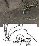
JesseJamesCampRRMap.jpg

Here is the $200K Coin Stash and Cave, with the Check-looking escarpment showing they broke the edges down to collape the opening and the rock adjacent to the opening that is a zig zag shaped 's' curve through the stone. The angle drawn is the reference point this location is used for the lay the star map over as well.
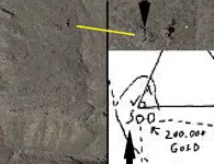
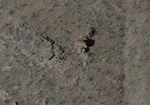
JesseJamesLeftOverlay.jpg JesseJamesLeftCloseup.jpg

And here is the 8 Block Marker and the P shaped rock on the adjacent side of the cave.
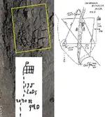
JesseJamesTroveRightcloseup.jpg

All these routes from the camp have a split stone, looking like a circle cut in half as a marker as well to guide to the path of the troves as marked by the dotted lines.

This one features the most amazing observation that probably wasnt noticed by them but is another 'Sign' something is placed there.
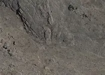
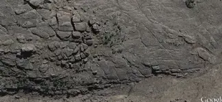
JesseJamesPointing.jpg JesseJamesTroveRight.jpg At the bottom where you follow the path up the ridge to the 8 Block and P #2020 trove, there is the image of a man standing and pointing a finger straight to the areas. Shows they had a sense of humor when they made the maps, chosing to walk right by this line following the finger to the troves !

Well as for the final clues and their derivatives, and how on earth did I find this area in the middle of nowhere.?

I found it looking for another trove in the area, and was taking pictures, which I noticed featured similar markings in the area of a set of maps from the KGC, and there seems to be a common strata that holds a landscape that these men are able to identify when traveling using their military mapping system. A sacred symmetry to it all is my guess.

I saw a straight line carved at least 1000yds long, and it was intersected by a triangular carved road and wondered why is this looking like something I recognixed........?

It was the corner of the star of David and the area is quite Biblical to be honest, so it is fitting as to the original settlers there, being also Mormon.

Let's collaborate on the solve if you want. When did the map get brought out of Colorado? Does anyone know?

I have already contacted Pinkerton Security via email and am waiting for the reply about this discovery and to see if they will fund the operation to reclaim this treasure located currently on Public Land, and within the open rights under the Colorado laws for lost or unclaimed and abandoned property. With no way to identify which source they got it from, there is a good chance they will work with me so I can retain a portion if not all of the recovered items.

To be honest there are other things buried there and in the vicinity.......A lot more.

I will update you all on the progress.....:occasion14:

James Simpson
Eldorado Enterprises Inc.
(802) 923-6838
 

OP
OP
Gooner

Gooner

Full Member
Dec 23, 2010
155
30
Pawhuska, Oklahoma
Detector(s) used
white's xlt
Your "check" is a number seven, in conjunction with a reversed number seven. The original map was of Spanish origin, and the twenty gold bars that weigh twenty pounds each came from nearby mines. The thing missing from the map is the number four, and off map are five trees planted in a specific configuration in accordance with the rules of the Codex. Also off map is a large turtle shaped rock, with three distinct humps on its back, and, sadly, with a severed head, to convey a specific message to the learned. The maps publicly available are copies, or worse yet, copies of copies.
 

OP
OP
Gooner

Gooner

Full Member
Dec 23, 2010
155
30
Pawhuska, Oklahoma
Detector(s) used
white's xlt
The ore from which the twenty ingots were smelted came from the "Tres Hermanos Minas." This was the original Spanish name for the mines. The name may have been recycled in more recent times, but the original mine locations are considered "lost." The $200,000 reference is to another location, and only a clue was hidden between the three boulders, and if you stand between them, you can touch two with your hands while resting a foot on the third. The two hundred grand in gold coins is actually supposed to be $219,000, and was hidden almost four miles away. This loot was cached by members of the James/Younger gangs. Last time I looked, the site had not been disturbed, so by reckoning, the 219 grand is most likely still there. This loot came from a military payroll and two train robberies.
 

OP
OP
Gooner

Gooner

Full Member
Dec 23, 2010
155
30
Pawhuska, Oklahoma
Detector(s) used
white's xlt
It may be of interest to some. The military payroll robbery was before the two train robberies, and, dressed in brand new uniforms, Jesse, Frank, Cole, and approximately 9 or 10 other individuals easily flagged down the trains. These two robberies happened in rapid succession, and since the military payroll was taken from a supply caravan, let your imagination run wild. Our boys posed as cowboys returning from a cattle drive, and after an encounter, a chance meeting, they took supper with the soldiers. After their bellies were full, a subtle signal was given, and within a few seconds, the ambush was complete. There are so many more details from the "family story" that I won't list them here, but I must say, my version of it would make one hellacious good movie.
 

Michael Brandes

Jr. Member
Apr 3, 2019
22
13
Chickasha, OK
Detector(s) used
Land Ranger Pro, Fisher TW-6 2 box
Primary Interest:
All Treasure Hunting
Sorry gooner but they are not boulders. they are 3 circles of rocks. the inner circle was smaller rocks surrounding the hole, and you can definitely see a round hole in the ground. Seems to be like a big been pot then a little bigger rocks circling them and the larger rocks circling them. that is where the 3 circles on map come from. not sure who thought they where boulders with all the kgb sign experts on this site With a cap stop on top covering the hole. i have seen this on google earth plain as day. it is on a fairly steep hill with boulders above it. i was looking at this on google maps so i decided to check out bing maps to see a different view although bing is fuzzy i could still see the 3 rock circles and cap stone moved. it looks like the cap stone had been moved that is how i seen the 3 round circles of different size rocks. now i have came to 3 conclusion. 1] someone found it and kick off cap stone. 2] with all the earthquakes in Oklahoma for 150 years very possible cap stone vibrated off or boulder run down hill and knocked it off, from an EQ which i hope to be the case. i will be going this fall to the site and taking my digital camera. if the loot is gone i will post pics if it not no picks[ clue]. also seen rock boot/foot not saying which dont want to give to much away and small over hang where JJ layed on is back and put his JJ on. will take pics of these also. going in fall after snakes stop moving around as much and weed are dieing off. I seen some pic on signs and the tree with the hole in it it said that meant buried.and the dotted lines are going to the 3 round circles. feel free to ask questions just don't think you will fool me into tell you much more. already said to much.
and the dry stream the two men where standing by. No the men where not still standing there as other claim to have seen. I did a distance from rock boot/foot to the capstone and at a 142 paces it showed to be like 480 ft [ i belivie 480 is right] but it worked out that much was right also.
 

Top Member Reactions

Users who are viewing this thread

Top