et1955
Hero Member
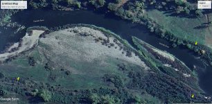
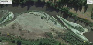
Got on google maps today and checked out my claim on the Klamath river, they updated there map of the area and wow has the river changed my claim, check out the 2 pics, one 1995 the other 2023. I see so many places to mine and also a major change there was a house above my claim which meant unless I had permission from them, I would have to access my claim threw extreme measures. Thanks to Land Matters I was able figure out what happened, the house is gone and the land has become N.S.F land so I can access my claim without out going threw private property. Question for you guys where would you guys start to mine on my claim ?
Amazon Forum Fav 👍


Attachments
Upvote
0
