You are using an out of date browser. It may not display this or other websites correctly.
You should upgrade or use an alternative browser.
You should upgrade or use an alternative browser.
Map symbol
- Thread starter pepperj
- Start date
- Joined
- Aug 19, 2014
- Messages
- 39,000
- Reaction score
- 143,637
- Golden Thread
- 0
- Location
- Tarpon Springs
- Detector(s) used
- JW 8X-ML X2-VP 585
- Primary Interest:
- All Treasure Hunting
Well...
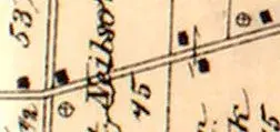
an "X" within a circle = Abandoned.
In most situations.
This appears a + sign as you say... letme looksee...
This map looks sorta familiar to me for some reason.
an "X" within a circle = Abandoned.
In most situations.
This appears a + sign as you say... letme looksee...
This map looks sorta familiar to me for some reason.
Upvote
0
- Joined
- Aug 19, 2014
- Messages
- 39,000
- Reaction score
- 143,637
- Golden Thread
- 0
- Location
- Tarpon Springs
- Detector(s) used
- JW 8X-ML X2-VP 585
- Primary Interest:
- All Treasure Hunting
X and O separated often mean "special items" as well.
Combined... it can mean "tree stump" in low water or marsh lands.
Combined... it can mean "tree stump" in low water or marsh lands.
Upvote
0
Crappies-n-Coins
Bronze Member
They're marked with a larger cross or CM usually on the maps.
If you're close enough to one of the areas you're asking about, you might go check it out. You may find the areas in question are smaller family cemeteries.
Upvote
0
Dakota Sioux
Sr. Member
- Joined
- Nov 11, 2015
- Messages
- 409
- Reaction score
- 1,188
- Golden Thread
- 0
- Location
- South Dakota
- Detector(s) used
- Garrett AT- Pro
- Primary Interest:
- All Treasure Hunting
Water Well?
Upvote
0
- Joined
- Aug 19, 2014
- Messages
- 39,000
- Reaction score
- 143,637
- Golden Thread
- 0
- Location
- Tarpon Springs
- Detector(s) used
- JW 8X-ML X2-VP 585
- Primary Interest:
- All Treasure Hunting
Um... Not a well.
Wells were mostly spelled out "well" Spring" etc...
IF abbreviated... "W".
Now I said MOSTLY". heh
Wells were mostly spelled out "well" Spring" etc...
IF abbreviated... "W".
Now I said MOSTLY". heh
Upvote
0
G.A.P.metal
Gold Member
A salt lick....that`s my guess !
Upvote
0
- Joined
- Aug 19, 2014
- Messages
- 39,000
- Reaction score
- 143,637
- Golden Thread
- 0
- Location
- Tarpon Springs
- Detector(s) used
- JW 8X-ML X2-VP 585
- Primary Interest:
- All Treasure Hunting
Just to throw this out there...
From the late 1700's (1790's) to the late 1800's the + sign represented a church.
The circle around it may indicate something "about" the church.
But ?
From the late 1700's (1790's) to the late 1800's the + sign represented a church.
The circle around it may indicate something "about" the church.
But ?
Upvote
0
fowledup
Silver Member
- Joined
- Jul 21, 2013
- Messages
- 2,757
- Reaction score
- 5,163
- Golden Thread
- 0
- Location
- Northern California
- Detector(s) used
- Whites GMT V/SAT
- Primary Interest:
- Prospecting
Is it maybe a 4 corner section marker from the Public Land Survey System?
Upvote
0
Similar threads
- Question
- Replies
- 8
- Views
- 610
Users who are viewing this thread
Total: 1 (members: 0, guests: 1)

