I'm having a  and can't seem to find out the meaning of this symbol in the picture which is from a 1870's historical map, which is a plus sign inside a circle.

Water Well?
Um... Not a well.
Wells were mostly spelled out "well" Spring" etc...
IF abbreviated... "W".
Now I said MOSTLY". heh

")

Wow...
Surprised this has not been "solved"...
Welp...
Since it seems that my first thought of a church has been "rejected" by many on this thread...
I went back into a search mode for you pepper...
And found this... here is one more suggestion...
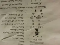
Here is a legend from a map from this period that depicts this symbol in 1810...
denoting a "cotton factory"... AKA a "mill" IMO...
Seems that perhaps cotton "milling" may have been going on in this area...
At first I thought that this did not make sense beings the general area is not cotton related... as far as "growing".
But textiles.
View attachment 1242182
Because no one is sure what it is yet . One more idea is it could be the location of a survey marker, such as this survey bolt like this one found in central park from 1811? Maybe a bench mark of sort.


When I try to figure out a small detail on a map, I look elsewhere on that map.
Helps to know the nation.
The British were everywhere during this period.
Perhaps they are camel stables in Africa ?
Maybe feeding stations in a British prison camp ?
Gathering sites for morning prayers ?
Icelandic hot springs ?
Australian tannery ?
A nation would really help.
Is this symbol in question, common throughout the map ?
Two, might be bawdy houses, bulletin boards, or dump pits ... possibilities times 100.
Fifty, might be outhouses, wells, or fruit stands ... possibilities times 100.
Do the symbols appear near waterways or railroads ?
Sawmills or gristmills come to mind.
What country or company drew up the map ?
Different symbols and styles could be researched, that way.
I think you are asking an awful lot, and providing very little, in a single, tiny speck of a map.