Mt. San Gorgonio with snow

Ray in CA

Hero Member
Joined
Oct 11, 2007
Messages
983
Reaction score
16
Golden Thread
0
Location
Quincy, CA
Detector(s) used
Minelab Safari with SEF 8x6; coming soon: FORS Gold+
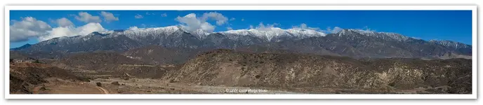
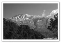
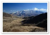
I finally got out today to take a few pictures of our snow dusted mountains. This is Mt. San Gorgonio, which in a good year can have plenty of snow on it. But so far this year it's just got a bit of a dusting.

This is a pano I stitched together from five frames taken by my Canon Digital Rebel XTi with a 28-80mm Sigma f/3.5 lens and a Hoya Circular Polarizer.

Sorry for the jaggies...jpeg compression must done something to the quality. The original looks great.

Enjoy!

Ray
 

Attachments

  • SanG_Pano.webp
    SanG_Pano.webp
    107.1 KB · Views: 277
Here's a couple more, but of Mt. San Jacinto which faces south, just opposite of Mt. San Gorgonio to the north. Mt. San Jacinto is a tad over 10,600 feet in elevation, and I believe it is the highest mountain in California that goes from sea level to summit.

Ray
 

Attachments

  • jacinto1.webp
    jacinto1.webp
    47.8 KB · Views: 242
  • jacinto2.webp
    jacinto2.webp
    54.3 KB · Views: 254
Absolutely stunning. Makes me want to pack up my bags and head to California! Ever detect any areas around any of the old Spanish missions out your way?
 

Ever detect any areas around any of the old Spanish missions out your way?

No, but I've yet to really do any research on any that are close by. There is one old Spanish adobe (or where an adobe used to be) high in Yucaipa that I've tried to locate, but where it should have been located looks to be surrounded by private land as far as I can tell.

I just got permission today, however, to search an adobe that was built by white men in the 1850s. I can't say which one it is or where it is located, but I'm looking forward to combing the grounds thoroughly with my Silver uMax!

Ray
 

Top picture looks like its taken from Florida at the base...My Idyllwild cabin is about mid-range
 

stefen, all pictures were taken at or near the Banning Bench. So the San Jacinto photos are looking south from top of north Banning.

Ray
 

Hey Ray great pics from up North....aa
 

Thanks aa battery!

Where are you located in so. Cal?

Ray
 

Great pics. Did you know that Frank Sinatra's Mother was killed in a plane crash on that mountain in January 1977? The plane hit so hard, that the engines were buried six feet underground. What was not recovered from the wreck was Sinatra's Mother's Jewelry Box containing about $250,000 ($250,000 in 1977 dollars) worth of jewelry.

Oh, and as far as detecting at old Spanish Mission Sites? Be prepared for a quick trip to jail if you get caught! Also be prepared to lose your metal detecting equipment, the vehicle you drove there in, your home computer, all research materials, a lot of money (in fines), a lot of time spent getting your vehicle back and fighting "Looting of Historical Artifacts" Charges filed under ARPA (Archaeological Resources Protection Act). Just a friendly warning. Even if you ask and get permission (which you won't), don't do a thing without getting your permission in writing.

Best-Mike!
 

Thanks gollum. With that info I'll be sure to avoid any missions in my detecting adventures!

Ray
 

Nice photos but at 11,502 feet Old Grayback or San Gorgonio Mountain/Peak is the tallest in SoCal. It’s called Old Grayback because when looking at it from the backside it stands out as a gray color compared to the rest of the San Bernardino Mountains.

It’s much harder to get to the register on top of Old Grayback than it is the one on MSJ. Most people give up at poop-out hill, an interesting hike for sure.


HH
 

Hey Ray Iam from Fresyes or also known as Fresno.
 

Thanks narragansett and Montana Elf Dude (why do I like saying that?)!

aa battery, I used to live in Fresno myself for four years, in an apartment adjacent to the college. I don't really miss it, lol.

Ray
 

Top Member Reactions

Users who are viewing this thread

Latest Discussions

Back
Top Bottom