MYSTERY ROCK

Sodabob

Sr. Member
Jan 14, 2019
273
191
Primary Interest:
All Treasure Hunting
Howdy

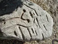
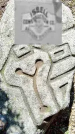
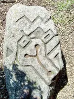
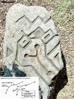
I haven't been around for a while and had to re-register with a different name. Anyway, I'm working on a real mystery and could use some help. If I can remember how to post pictures, please notice the carved images in what locals call "The Mystery Rock." I have been asked by our local Historical Society / Museum to research it, and depending on the results here, might write an article for them in their newsletter. The rock has already been examined by a group of Archaeologist but they are baffled as to what the carvings might be or represent. The only thing they determined with any certainty is that the carvings were done with some type of steel tool such as a chisel. As for the date it was carved, they are baffled about that as well. Its located in a brushy area about 100 feet away from an old State highway and about 100 yards from an old Railroad line that was built in 1916. In the area there is also an old U.S. military encampment that was built in 1940-41 and sold to the County around 1947-48. The two most prominent theories are ...

1. The rock was carved by a Railroad worker
2. The rock was carved by a member of the Military

But regardless of who carved it or when, we are trying to determine what the carvings might be or represent? The archaeologist said they don't recognize the pattern and are pretty sure they are not Aztec or anything like that, and that they might be random that only the "carver" knows the meaning of.

If you have any theories or recognize the pattern as something specific, please let me know and I will pass the information on to the Historical Society. The rock is located about 50 miles east of San Diego along old Highway 94.

Thanks in advance to those who participate in possibly solving a mystery that has had locals baffled for several years.

Sodabob ... a.k.a. Sodabottlebob and Sodapopbob


The rock is about 6 feet long, 3 feet wide, and about 2 feet thick. Most of the carving are on one end of the rock but in some places continue over the side. The local museum has permits to move it next Spring but will need a backhoe to lift and transport it.
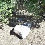
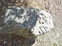
100_5380.JPG

100_5377.JPG

100_5378.JPG
 

Last edited:
OP
OP
Sodabob

Sodabob

Sr. Member
Jan 14, 2019
273
191
Primary Interest:
All Treasure Hunting
Have I stumbled onto something or just headed down another rabbit hole?


Exhibit #1

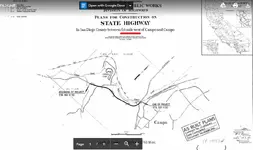
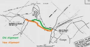
Highway Survey Map - Dated June 3, 1963

Notice where I underlined "0.8 Miles"

Isbelle Construction Campo Highway Survey.JPG


Exhibit #2

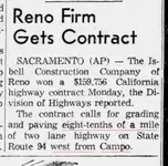
Reno, Nevada Newspaper Article - August 13, 1963

Notice where I underlined "eight-tenths of a mile west from Campo"

View attachment Isbell Construction Campo Highway Project Reno_Gazette_Journal_Tue__Aug_13__1963_ (2).jpg


Exhibit #3

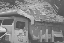
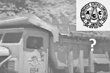
This is the only picture of a Isbell Construction Company truck I have found

Notice their insignia/logo on the door

Isbell Construction Company Truck (2).jpg


Exhibit #4

Does the skull-like design from the truck look like the skull-like design on the Mystery Rock?

Notice what appears to be three dots and a squarish cutout on the "forehead" on the truck logo, plus the straight angles around the "face"

Isbell Construction Mystery Rock Overhead Shot.jpg
 

Last edited:
Upvote 0
OP
OP
Sodabob

Sodabob

Sr. Member
Jan 14, 2019
273
191
Primary Interest:
All Treasure Hunting
DCMatt

You could be right. The keyword in the article seems to be "from" Campo. To me that could mean "starting" at Campo or "away" from Campo. But more than anything else I would like to find a good picture of the logo on one of the Isbell Construction Co. trucks and see what that looks like.


Edit: What happened to DCMatt's post ?
 

Last edited:
Upvote 0
OP
OP
Sodabob

Sodabob

Sr. Member
Jan 14, 2019
273
191
Primary Interest:
All Treasure Hunting
P.S.

Notice the dark line on the survey map where it says "Beginning of Project" and "End of Project." That's the new alignment!
 

Upvote 0
OP
OP
Sodabob

Sodabob

Sr. Member
Jan 14, 2019
273
191
Primary Interest:
All Treasure Hunting
Just for the record ...

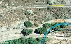
The Mystery Rock and the Grinding Holes are both located within the 'island' of land between the old highway and the new highway

Campo Highway Survey (3).jpg
 

Last edited:
Upvote 0
OP
OP
Sodabob

Sodabob

Sr. Member
Jan 14, 2019
273
191
Primary Interest:
All Treasure Hunting
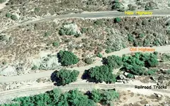
Google Earth of the same 'island' of land between the old highway and the new highway. The Mystery Rock and the Grinding Holes are both located in this area.

(At the appropriate time I will mark their exact locations)

Mystery Rock Google Earth.JPG
 

Upvote 0
OP
OP
Sodabob

Sodabob

Sr. Member
Jan 14, 2019
273
191
Primary Interest:
All Treasure Hunting
Correction ...

I just heard from my Caltrans contact and he confirmed the highway project in question was completed in 1964 and not in 1966-67 as I previously thought. So much for my memory of being in High School at the time. In 1964 I was in the 6th grade and attended the Elementary School that was located about one mile north of the highway project. But that's okay because 1964 ties in better with the 1963 newspaper article I posted earlier about the Isbell Construction Company.
 

Upvote 0

Johnbrian

Full Member
Jun 15, 2017
114
122
Bakersfield, CA
Detector(s) used
Garrett Ace 250, White's 3900/D
Primary Interest:
Metal Detecting
Speaking of my research regarding the highway project, I contacted the California Department of Transportation (Caltrans) and they sent me 26 images of the original plans for the survey that was conducted in 1963-64. I'm still working on this but can say with a measure of confidence if the Mystery Rock was carved prior to the survey that they would surely have seen it. According to the plans they sent me, they surveyed every inch of that area between the project site itself and the railroad tracks. I believe there is no way they could not have seen the rock if it had carvings on it at the time (1963-64). And if they did see it, you'd think they would have mentioned it to someone? This attachment is just one of the 26 plans they sent me. The Caltrans individual I'm working with is supposed to send me some more information about the highway project and I will do a follow-up when I hear from them.

It may have not ended up in the official record because it may have postponed the project due to an archaeological investigation. So it was swept under the table. Just a thought . . .
 

Last edited:
Upvote 0
OP
OP
Sodabob

Sodabob

Sr. Member
Jan 14, 2019
273
191
Primary Interest:
All Treasure Hunting
Jb

Not "Just a thought" but an intelligent observation. Thanks. Something like that could very well have happened and it wouldn't surprise me if it did. That is, if someone with the Isbell Construction Company didn't carve it themselves? I'm still researching the Isbell Construction Company possibility and will continue with that until I hit a dead end. In the meantime, here are the copy/pasted remarks the Caltrans representative sent me ...


Hi Bob,

I haven’t found anything new, but the as-built plans that I sent you may provide some illumination. The title sheet for As-Built Plan 64-11v13c10 shows in the lower right-hand corner that the project was completed in 1964. Construction plans are produced and approved in advance of the start of a job, but the plans are only stamped “As-Built” after the completion of the project. This would indicate that the construction took place at some point during or prior to 1964. Considering that the re-alignment was only 0.8 miles, construction of the new roadway may have taken only a few months. Isbell Construction Company could have been awarded the contract to grade and pave the new road in August of 1963 and completed the job by early to mid 1964. This would fit into the time frame of the approval of the construction plans (June 3, 1963) and the “As-Built” stamping in 1964. This is my best guess without doing much more extensive research into the matter. If you have any questions or would like to discuss the matter further, please contact me at your convenience.
 

Last edited:
Upvote 0
OP
OP
Sodabob

Sodabob

Sr. Member
Jan 14, 2019
273
191
Primary Interest:
All Treasure Hunting
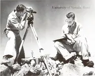
Maybe it was these guys ...

Isbell Construction Company survey crew ~ 1953

Isbell Construction Company Survey Crew.jpg


Or maybe it was this guy ...

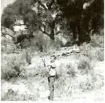
Wait a minute! That's me in 1964 when I was in the 6th grade. I'm holding a quail my brother shot and have my Kodak Brownie camera case slung over my shoulder. My brother wanted a picture of the quail, not of me! (Lol)

Bobby with quail 1964.jpg
 

Last edited:
Upvote 0
OP
OP
Sodabob

Sodabob

Sr. Member
Jan 14, 2019
273
191
Primary Interest:
All Treasure Hunting
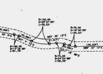
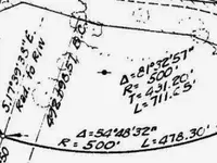
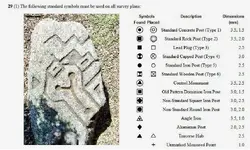
I haven't hit a dead end yet with the Highway Project stuff but have definitely come to a fork in the road. So the direction I'm heading into next is to take a look at various surveying marks and symbols and see if I can find anything definitive that might correlate with the carvings on the Mystery Rock. It will probably just take me down another rabbit hole, but that's okay because I have been down there before and its not as bad as it sounds. For starters are these samplings from the AS-BUILT plans that I'm trying to make sense of. There are no Legends on the plans to explain what's what but I hope to figure some of that out as I go along.

Notice the Y shaped marks in this first example.

Mystery Rock Survey Marks.JPG


Notice the Triangle symbol in this next example.

Mystery Rock Survey Symbols.JPG


100_5503 (2).jpg
 

Last edited:
Upvote 0

Plug N Play

Bronze Member
Aug 23, 2014
1,315
3,573
California
Detector(s) used
De Havilland Canada DHC-7-102 Dash 7 - Fugro
Primary Interest:
All Treasure Hunting
I'd like to see a general map that outlines the water ways. (similar to your road and railroad maps)
The bedrock mortar would be directly associated with the creek, I'm almost certain.
Not seeing a water connection with this rock, but, would like to know where the water runs through this area.

Also, am I seeing a large boat next to a small pond ? ... something along those lines? LOL
 

Upvote 0
OP
OP
Sodabob

Sodabob

Sr. Member
Jan 14, 2019
273
191
Primary Interest:
All Treasure Hunting
PNP

Other than areas of general runoff and culverts, the creek is the only natural waterway. Please clarify what you mean about the boat and pond ???

Mystery Rock Google Earth (2).jpg
 

Upvote 0

Plug N Play

Bronze Member
Aug 23, 2014
1,315
3,573
California
Detector(s) used
De Havilland Canada DHC-7-102 Dash 7 - Fugro
Primary Interest:
All Treasure Hunting
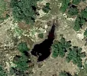
A tad to the north, I believe. Seeing this:

boat.jpg

Edit: Was this water source available, in addition to the creek ... in the past ?
 

Last edited:
Upvote 0
OP
OP
Sodabob

Sodabob

Sr. Member
Jan 14, 2019
273
191
Primary Interest:
All Treasure Hunting
PNP

I don't know what that is or where it might be. How far north is it from the Railroad tracks? It looks like a pond but I don't know of any ponds in the immediate area. Campo Lake is about 1/2 mile to the Northwest but its much larger than that. And even if Campo Lake was trained dry, the shoreline wouldn't look like that. ???
 

Upvote 0
OP
OP
Sodabob

Sodabob

Sr. Member
Jan 14, 2019
273
191
Primary Interest:
All Treasure Hunting
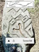
I'm still intrigued with Traverse survey symbols. Here's a typical definition of Traverse Surveying ...


A survey used especially for long narrow strips of country in which a series of lines joined end to end are completely determined as to length and azimuth and are often used as a basis for triangulation.

The reason I'm intrigued with them is due to the Triangles carved into the rock. Especially when you take into account that the two most prominent triangles on the rock are different: One is framed and one isn't. Just as there are two different Traverse Hub symbols: One is darkened and one isn't. But whatever the explanation might be, I still believe the carved designs on the rock were intentional and mean "something."

Mystery Rock Traverse Hub (2).jpg
 

Upvote 0

Plug N Play

Bronze Member
Aug 23, 2014
1,315
3,573
California
Detector(s) used
De Havilland Canada DHC-7-102 Dash 7 - Fugro
Primary Interest:
All Treasure Hunting
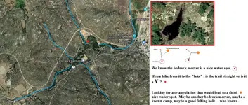
Pondering the map idea.

Trying to determine what the three main water sites may have been in prehistoric times.
Was the "lake" a modern "dam" ? ... either way, it may have been a nice water site.

If we look at the natural hike between the bedrock mortar and this Campo Lake? site, is there another natural path that branches off and goes to another, yet to be determined site ?


Campo triangulation.jpg
 

Upvote 0
OP
OP
Sodabob

Sodabob

Sr. Member
Jan 14, 2019
273
191
Primary Interest:
All Treasure Hunting
PNP

I just now saw your post and will have to give it some more thought before commenting further, but I can tell you that ...

1. The only natural water course I am aware of in the area is Campo Creek.
2. Campo Lake is on Campo Creek and was created by building a dirt and rock dam.
3. Other than Campo valley to the east, the entire area where Campo Creek flows to the west is surrounded by mountains.
4. There are meadows along the creek, but other than that is mostly mountains.
5. At some point Campo Creek turns south and flows into Mexico.
6. Any ponds in the area are man made to water cattle.
7. As far as there being ancient water sources, there is no evidence of it and is doubtful.

I hope this answers some of your questions - if not, ask away!
 

Upvote 0

Top Member Reactions

Users who are viewing this thread

Top