Stone Map

kaimdaim

Greenie
Jan 14, 2019
16
13
Detector(s) used
Self made Resistivity (Electrical Tomography) system
Primary Interest:
All Treasure Hunting
Hello,
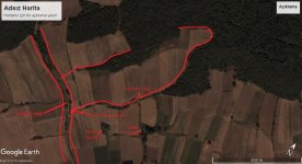
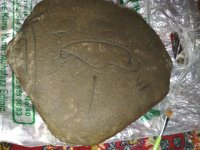
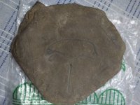
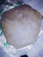
We have found out this map stone buried 2 feet subsurface.Here I attach photos of the map and also aerial photo of the field.I call it map since you would already see on the aerial photo of the burial point.I expect your comments and ideas about what it might be telling exactly and how should the triangulation be done according to the ancient numerals on the map.
 

Attachments

  • aerial.jpg
    aerial.jpg
    93.1 KB · Views: 162
  • IMG_20190114_184517.jpg
    IMG_20190114_184517.jpg
    1.4 MB · Views: 181
  • IMG_20190115_005001.jpg
    IMG_20190115_005001.jpg
    1.2 MB · Views: 126
  • IMG_20190115_000656.jpg
    IMG_20190115_000656.jpg
    1.3 MB · Views: 129

Icewing

Silver Member
Jan 5, 2016
2,633
5,494
NW Arkanslaw
Detector(s) used
Minelab Equinox 900 / Garrett PropointerAT.
Primary Interest:
All Treasure Hunting
I think it is to be read with the two solid lines at the bottom and the sun at the top. Beyond that I'd guess the line through the sun indicates 1/2 day travel, and the numbers may be hours it takes to get from place to place.

But that is all 100% guess work and should be taken as such.

What country are you in?
 

Upvote 0
OP
OP
K

kaimdaim

Greenie
Jan 14, 2019
16
13
Detector(s) used
Self made Resistivity (Electrical Tomography) system
Primary Interest:
All Treasure Hunting
I think it is to be read with the two solid lines at the bottom and the sun at the top. Beyond that I'd guess the line through the sun indicates 1/2 day travel, and the numbers may be hours it takes to get from place to place.

But that is all 100% guess work and should be taken as such.

What country are you in?


Actually I guess the sun figure is compass,as sun goes from east to west,and upper side is north and down as south then...if you check the compass of aerial photo,then you can see the shapes of aerial photo and stone map correspond and match each other.About numbers;well V-VI,5 and 6 ifRoman numerals,but then what might be the one accross V?Is it 1?or isnt it a number but telling something else?
 

Upvote 0

coinman123

Silver Member
Feb 21, 2013
4,659
5,768
New England, Somewhere Metal Detecting in the Wood
🥇 Banner finds
2
🏆 Honorable Mentions:
1
Detector(s) used
Teknetics T2 SE (DST)
Spare Teknetics T2 SE (backup)
15" T2 coil
Pro-Pointer
Bounty Hunter Pioneer 202
Fisher F2
Fisher F-Point
Primary Interest:
Other
Reminds me of some kind of sundial, though I am likely wrong. Really amazing find though, whatever it ends up being!
 

Upvote 0

cudamark

Gold Member
Top Banner Poster
Mar 16, 2011
13,223
14,552
San Diego
🥇 Banner finds
1
🏆 Honorable Mentions:
3
Detector(s) used
XP Deus 2, Equinox 800/900, Fisher Impulse AQ, E-Trac, 3 Excal 1000's, White's TM808, VibraProbe, 15" NEL Attack, Mi6, Steath 920ix and 720i scoops, TRX, etc....
Primary Interest:
All Treasure Hunting
If it pointed to something, it's going to be hard to determine now that it's been removed from it's original location unless you took meticulous measurements and/or photos so it can be placed back exactly as it was.
 

Upvote 0
OP
OP
K

kaimdaim

Greenie
Jan 14, 2019
16
13
Detector(s) used
Self made Resistivity (Electrical Tomography) system
Primary Interest:
All Treasure Hunting
If it pointed to something, it's going to be hard to determine now that it's been removed from it's original location unless you took meticulous measurements and/or photos so it can be placed back exactly as it was.

Actually I think the stone map has got its own compass,as that sun figure (from east-right, to west-left;and north is upwards,south is downwards of the sun).It looks he who carved this map on the stone knew basic cartography.
 

Upvote 0

RGINN

Gold Member
Oct 16, 2007
8,613
10,764
Summit County, CO
🏆 Honorable Mentions:
1
Detector(s) used
White's DFX, White's Classic 1 Coinmaster, Nokta Pointer
Primary Interest:
All Treasure Hunting
Why would you bury a map 2 feet in the ground? Hard to say much without knowing what culture it's associated with.
 

Upvote 0

Azquester

Bronze Member
Dec 15, 2006
1,736
2,596
Primary Interest:
All Treasure Hunting
It shows that on each end of a trail or road is one of each "V" and "VI". The roads loop around each other and you dig halfway between the two. I'd get a really good Minelab with a huge coil and look between those old wagon trails. "X' out the middle of the odd shaped loop. Two trail or lines, each has a symbol one has a two legged "Y" or "V" and the other has the "VI" together as a Turkey Track symbol. The Sun is actually a dig symbol or hole in the ground. It could be a well or spring that has treasure halfway down. Nice stone map!
 

Upvote 0
OP
OP
K

kaimdaim

Greenie
Jan 14, 2019
16
13
Detector(s) used
Self made Resistivity (Electrical Tomography) system
Primary Interest:
All Treasure Hunting
It shows that on each end of a trail or road is one of each "V" and "VI". The roads loop around each other and you dig halfway between the two. I'd get a really good Minelab with a huge coil and look between those old wagon trails. "X' out the middle of the odd shaped loop. Two trail or lines, each has a symbol one has a two legged "Y" or "V" and the other has the "VI" together as a Turkey Track symbol. The Sun is actually a dig symbol or hole in the ground. It could be a well or spring that has treasure halfway down. Nice stone map!

That's such a careful look,thanks for that!
And now, may I ask the way you would apply the stone map on the aerial photo?
 

Upvote 0

Sodabob

Sr. Member
Jan 14, 2019
273
191
Primary Interest:
All Treasure Hunting
I seem to recall from somewhere that when a sun symbol has a line through it, and the the larger part of the sun is below the line, that indicates sunset or West. And because the aerial map shows North pointing at at angle to the right, I positioned the stone as best I could with the setting sun toward the upper-left of the map. I wouldn't take this to the bank, but its the best I can come up with. I positioned the stone directly over where it was found. If necessary, save and zoom for details. Or just click on it to enlarge.

Stone Map Aerial Combo.jpg
 

Last edited:
Upvote 0

Azquester

Bronze Member
Dec 15, 2006
1,736
2,596
Primary Interest:
All Treasure Hunting
I thought about it a bit. The symbol that looks like a sun may in fact be the north star. That would indicate true north which is more suited for finding treasures or objects. The Free Masons used true north as it never changes like magnetic north does over the centuries. Any map that was meant to be used would need to be made in this fashion.

Either that or it represents a sink hole or natural sunken area.

Just My Opinion.
 

Upvote 0

irongate

Newbie
Jul 29, 2006
2
4
Well it looks like a Terminus stone. They were used by the Romans to mark land and perform sacrifices to the Roman god Terminus, the god of boundary's (the Romans had many gods) the fest day was on the 23 of February and the stones were anointed with blood as a sacrifice to the god to insure a good crop year.
 

Upvote 0
OP
OP
K

kaimdaim

Greenie
Jan 14, 2019
16
13
Detector(s) used
Self made Resistivity (Electrical Tomography) system
Primary Interest:
All Treasure Hunting
I thought about it a bit. The symbol that looks like a sun may in fact be the north star. That would indicate true north which is more suited for finding treasures or objects. The Free Masons used true north as it never changes like magnetic north does over the centuries. Any map that was meant to be used would need to be made in this fashion.

Either that or it represents a sink hole or natural sunken area.

Just My Opinion.

Hi,
This point of view of yours makes sense more than anything else that I have ever heard.So,I think,it is all about triangulation problem with this map.
 

Upvote 0
OP
OP
K

kaimdaim

Greenie
Jan 14, 2019
16
13
Detector(s) used
Self made Resistivity (Electrical Tomography) system
Primary Interest:
All Treasure Hunting
I seem to recall from somewhere that when a sun symbol has a line through it, and the the larger part of the sun is below the line, that indicates sunset or West. And because the aerial map shows North pointing at at angle to the right, I positioned the stone as best I could with the setting sun toward the upper-left of the map. I wouldn't take this to the bank, but its the best I can come up with. I positioned the stone directly over where it was found. If necessary, save and zoom for details. Or just click on it to enlarge.

View attachment 1671711

Here as inspired from your opinion I make up a solution including two steps.First step applying the map with its figures which show the natural features(like ancient dirt road,natural water spring,the surrounding area which is drawn on the map)to give an estimated triangulation point;the second step applying the odd shape of the stone on a certain field on the ground which approximately corresponds with that odd shape.Then it needs to read the V(5) and VI(6) with hundreds digits,as 500 and 600 meters,so that the latter correspondence also matches with these distances.(The distance of last upper left edge of the stone matching on the ground within the areial photo from the digging point where stone was found is 500 meters;the end of ancient dirt road near the turkey track to that same upper left side of stone is 600 meters).
aer.jpg
aer1.jpg
aer2.jpg
 

Last edited:
Upvote 0
OP
OP
K

kaimdaim

Greenie
Jan 14, 2019
16
13
Detector(s) used
Self made Resistivity (Electrical Tomography) system
Primary Interest:
All Treasure Hunting
Well it looks like a Terminus stone. They were used by the Romans to mark land and perform sacrifices to the Roman god Terminus, the god of boundary's (the Romans had many gods) the fest day was on the 23 of February and the stones were anointed with blood as a sacrifice to the god to insure a good crop year.

I have to respect your opinion but as far as I knew Terminus stone needs to be as a stele(obelisk).This one was just buried in the ground beneath a preserving big rock piece cut as a tiny slice.
 

Upvote 0

ANTIQUARIAN

Gold Member
Apr 24, 2010
12,841
27,385
Upper Canada 🇨🇦
🥇 Banner finds
1
🏆 Honorable Mentions:
3
Detector(s) used
XP Deus, Lesche Piranha 35 Shovel & 'Garrett Carrot'
Primary Interest:
Relic Hunting
I think it is to be read with the two solid lines at the bottom and the sun at the top. Beyond that I'd guess the line through the sun indicates 1/2 day travel, and the numbers may be hours it takes to get from place to place.

But that is all 100% guess work and should be taken as such.

What country are you in?

I think it's interesting that you don't want to tell us in what country you're located it in... why is it secret? :icon_scratch:
The only reason I ask is, it could help us help you with getting to the bottom of your 'stone map'

Dave
 

Upvote 0
OP
OP
K

kaimdaim

Greenie
Jan 14, 2019
16
13
Detector(s) used
Self made Resistivity (Electrical Tomography) system
Primary Interest:
All Treasure Hunting
I think it's interesting that you don't want to tell us in what country you're located it in... why is it secret? :icon_scratch:
The only reason I ask is, it could help us help you with getting to the bottom of your 'stone map'

Dave
The country of the stone map is Turkey,Samsun region.
I have never intended to keep a secret;if I havent told about the country and the region of the stone map,it is just because of my oversight which was from excitement of the deed.If I would keep a secret,then why would I be here asking for your ideas? :)
 

Upvote 0

Top Member Reactions

Users who are viewing this thread

Top