MYSTERY ROCK

Sodabob

Sr. Member
Jan 14, 2019
273
191
Primary Interest:
All Treasure Hunting
Howdy

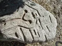
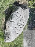
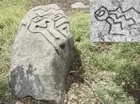
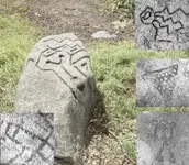
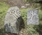
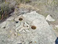
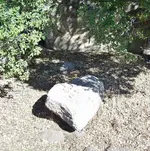
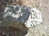
I haven't been around for a while and had to re-register with a different name. Anyway, I'm working on a real mystery and could use some help. If I can remember how to post pictures, please notice the carved images in what locals call "The Mystery Rock." I have been asked by our local Historical Society / Museum to research it, and depending on the results here, might write an article for them in their newsletter. The rock has already been examined by a group of Archaeologist but they are baffled as to what the carvings might be or represent. The only thing they determined with any certainty is that the carvings were done with some type of steel tool such as a chisel. As for the date it was carved, they are baffled about that as well. Its located in a brushy area about 100 feet away from an old State highway and about 100 yards from an old Railroad line that was built in 1916. In the area there is also an old U.S. military encampment that was built in 1940-41 and sold to the County around 1947-48. The two most prominent theories are ...

1. The rock was carved by a Railroad worker
2. The rock was carved by a member of the Military

But regardless of who carved it or when, we are trying to determine what the carvings might be or represent? The archaeologist said they don't recognize the pattern and are pretty sure they are not Aztec or anything like that, and that they might be random that only the "carver" knows the meaning of.

If you have any theories or recognize the pattern as something specific, please let me know and I will pass the information on to the Historical Society. The rock is located about 50 miles east of San Diego along old Highway 94.

Thanks in advance to those who participate in possibly solving a mystery that has had locals baffled for several years.

Sodabob ... a.k.a. Sodabottlebob and Sodapopbob


The rock is about 6 feet long, 3 feet wide, and about 2 feet thick. Most of the carving are on one end of the rock but in some places continue over the side. The local museum has permits to move it next Spring but will need a backhoe to lift and transport it.
100_5380.JPG

100_5377.JPG

100_5378.JPG
 

Last edited:
sailaway

Very interesting and a possibility. Even though it hasn't been fully addressed yet, the railroad line that was completed in the area in 1915 used Chinese laborers. I'm searching now for documentation to support that claim and will post them if/when I find any. I may have to go to our local railroad museum to find anything but they are only open on the weekends and will have to wait until then.

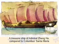
Just remember that the carving may predate Europeans in America (excluding the Templar and Norsemen). You are looking in the right direction though. The Chinese had ship building facilities in California years before Columbus made it to the Americas. Because there was a infrastructure and inhabitants, they may have needed road signs to direct resources going to the ship building areas, it also makes me wonder if it is connected to what they are finding on the U.S. east coast. The Chinese had along with them, men skilled with hard rock carving, because they mined hard rock for anchors. I do not believe they rounded the horn to get to the Gulf of Mexico. but overland to the Caribbean/Gulf is a possibility. The reason I feel this way is the fact that the Amazon was not charted in South America, yet it shows the Mississippi, and the Yucatan is clearly visible. This means that the east coast of Central America was known to them.
Wavy lines on your rock, face the ocean, so the rock does appear to be a direction marker.
Note: Be very careful tampering with the rock as it may be protected by the Antiquities Laws
My advice is to contact local higher education history department for funding and research (UCLA or other)
ZH.PNG

http://www.cawreckdivers.org/Chinese Anchors.htm

http://www.molossia.org/chinese.html

http://www.gavinmenzies.net/Evidenc...facts-found-in-the-wake-of-the-chinese-fleet/

https://en.wikipedia.org/wiki/Shipbuilding

Columbus had a copy of the map brought back by Marco Polo in 1295.

"The Mysteries of the Marco Polo Maps" by BENJAMIN B. OLSHIN
https://www.press.uchicago.edu/ucp/books/book/chicago/M/bo18178708.html

https://sandiegodowntownnews.com/junk-ships-in-san-diego-bay/
Murray Lee, a former Merchant Marine and author of “In Search of Gold Mountain: A History of the Chinese in San Diego.”

If a proven date can be established on this rock, it could rewrite history of the area.
 

Last edited:
Upvote 0
sailaway

I like everything you posted, especially the part about the wavy/zig-zag lines being on the West side and possibly indicating the Pacific Ocean. However, the more I think about and research that crazy rock, the more I'm beginning to think we are missing something essential. Sort of like not being able to see the forest because of the trees. In other words, I'm now leaning toward the possibility that it was carved a lot later than I previously thought. Like, maybe in the 1960s. The reason I say that is because in 1966-67 they blasted part of a hill away near the Mystery Rock in order to construct a new alignment for the state highway that was shorter and straighter than the old section. I'm thinking when they did that construction work that one of their drill guys or a powder monkey might have had some free time on his hands and took a power tool of some type and buzzed the design into the rock. Of course this is pure speculation like everything else, and even if its true it doesn't explain the design itself, but I honestly feel its worth looking into to see what, if anything, I can find that might connect that 1966-67 road project to the Mystery Rock.
 

Upvote 0
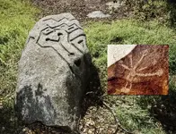
I'm still researching the possible 1966-67 Highway project connection, but thought I post this in the meantime. The insert is a Kumeyaay inscription on a rock that's within 40 miles of the Mystery Rock. Its probably nothing to excited about, but it has certain aspects that intrigue me. I especially like the round ends on the lines. I just found it and will do an update after I research it a little more.


Mystery Rock (18).jpg


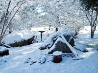
Just for the heck of it, here's what my back yard looked like this morning ...

Snow Feb 22, 2019.JPG
 

Last edited:
Upvote 0
P.S.

I'm not sure which direction the Kumeyaay inscription goes, so here it is again, but inverted ...

Kumeyaay Inscription.jpg


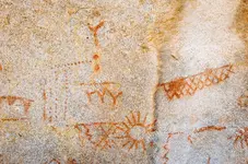
Plus I wanted to add these other Kumeyaay pictographs I thought were interesting. Notice the Y shapes ...

Kumeyaay Pictographs.jpg
 

Upvote 0
I wonder if I have stumbled onto something or just heading down another rabbit hole?


Mystery Rock (19).jpg
 

Upvote 0
From the same archaeological site as the last one.

Mystery Rock (20).jpg
 

Upvote 0
24 MARCH, 2018 - 01:02 ANCIENT-ORIGINS
Enigmatic Carvings on Underwater Ruins in China Mystify Investigators
On some other stones were carved signs looking like Roman numeral “1” and the English letter “y” arranged in a row. The symbol on the stone is believed to be even older than the Spring and Autumn Period (722-481BC) far more than 1,800 years old.
https://www.ancient-origins.net/une...ater-ruins-china-mystify-investigators-009794
I do wonder if the rock was not displaced when the hillside was blasted for the road project or that there are not more carvings that were part of a larger statement. Or is this a modern fake? The stone does not appear to be very far into the ground. My Granddad had a stone sharpening wheel that has now sunk out of sight in his yard after 60 years.
 

Last edited:
Upvote 0
I'm still leaning towards quick, simple, and with power tools. Good tools, limited in number, but the person was experienced with using those tools.
The situation mentioned in the 1960's, that would make this pretty easy.
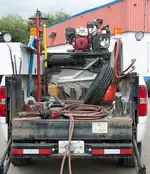
You pull a work truck up to this, with a compressor and 110 volts ... maybe camp there while working a job ... a weekend off ... ?
It's nothing more than unrolling an extension cord ... roll out a 1/2" air hose ........ hold my beer and don't let the dust get in it.

Considering native and primitive origin, it's not matching the design I'm looking at, it's the cuts made ... These cuts are too deep and too square cut ... too "blatant", if that makes sense. I wouldn't think they could matched up well with primitive cuts from that area.

But those cuts sure look like they would match up perfectly with modern power tools.
 

Upvote 0
Thanks for the comments. I don't think the rock was carved by Native Americans, but I do think its possible that whoever did carve it might have been influenced by a Native American design. And what better design to use than that of the local indigenous people, the Kumeyaay? In other words, possibly someone with a power tool who either was a present day Native American or knew enough about them to use some of their symbolism in his creation with a slightly modernistic look to it. This might turn out to be the rabbit hole I mentioned earlier, but for the time being I'm heading down it and see where it leads.

Rabbit Hole.jpg
 

Last edited:
Upvote 0
This will be the last one for a while. I just wanted to show some of the Kumeyaay designs I've found so far before I take the plunge down that rabbit hole I keep talking about.

Mystery Rock (21).jpg
 

Last edited:
Upvote 0
well,i worked for the railroad for 38yrs,and I know a spike is way to soft to be used for a chisel! other than that haven't got a clue! good luck!
 

Upvote 0
well,i worked for the railroad for 38yrs,and I know a spike is way to soft to be used for a chisel! other than that haven't got a clue! good luck!

goober

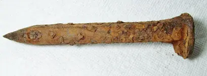
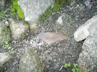
Thanks for stopping by. I agree because I tried it with a railroad spike like the one I found under the Mystery Rock. I'm still of the opinion it was done with some type of power tool. But whether that power tool was pneumatic or electric, I do not know.

Mystery Rock Railroad Spike February 11, 2019.jpg
 

Upvote 0
I'm still down that rabbit hole and while having tea with the Mad Hatter he pointed me in the direction of this Native American petroglyph that's within easy driving distance of the Mystery Rock. I'll tell you more about it after I have thoroughly researched it.

Mystery Rock (1).jpg
 

Upvote 0
Air x 2 ... electric would work, ... air would be much faster, smoother, and efficient.
Tire shops have air ... personal uses, electric is very common.

Lug wrench.jpg

Small truck ... large air lines ... this set-up would deliver industrial strength power anywhere you needed it.

TruckCompressor.jpg
 

Upvote 0
It will be interesting to see what you find out. Its abeautiful stone.
 

Upvote 0
Coincidence or Connection?

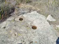
I explored an approximately five acre area around the Mystery Rock yesterday and found these Native American grinding holes about 200 yards away from the rock. Two of the holes were filled with water from our recent rain and the hole in the foreground was filled with sand and debris such as twigs. I didn't clean out the holes but by probing them with a screwdriver was able to determine they averaged about 5" inches deep. But what really captured my attention is that there were three of them and they formed a somewhat triangular shape. I wonder if the person who carved the Mystery Rock was influenced by these grinding holes?

100_5493 (2).jpg

100_5493.JPG
 

Upvote 0
There were also pottery shards in the area as well as chips of various types of stone for making arrowheads. The shard shown here is about the size of the palm of my hand and is typical of others I saw scattered around the area.

100_5509.JPG


This next attachment is for those who requested a pic of the carving from directly over it. Triple click and you will see a quarter I placed on the rock for size. You can also see the tips of my shoes in the shadows at the bottom.

100_5503 (2).jpg
 

Upvote 0
Here's a couple of more pics I took yesterday ...

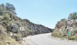
This is the highway gap I have been talking about that I recall hearing the explosions from during its construction while I was a student at the nearby High School in 1966-67. I'm still researching this project to see if there might be a connection between it and the Mystery Rock.

100_5488.JPG

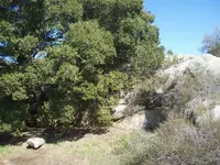
In this pic the Mystery Rock is the one in the lower left with a large oak tree and rock cliff behind it.

100_5499.JPG
 

Upvote 0
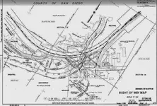
Speaking of my research regarding the highway project, I contacted the California Department of Transportation (Caltrans) and they sent me 26 images of the original plans for the survey that was conducted in 1963-64. I'm still working on this but can say with a measure of confidence if the Mystery Rock was carved prior to the survey that they would surely have seen it. According to the plans they sent me, they surveyed every inch of that area between the project site itself and the railroad tracks. I believe there is no way they could not have seen the rock if it had carvings on it at the time (1963-64). And if they did see it, you'd think they would have mentioned it to someone? This attachment is just one of the 26 plans they sent me. The Caltrans individual I'm working with is supposed to send me some more information about the highway project and I will do a follow-up when I hear from them.


Highway Survey Plan 1963-64.jpg
 

Upvote 0

Top Member Reactions

Users who are viewing this thread

Back
Top