You are using an out of date browser. It may not display this or other websites correctly.
You should upgrade or use an alternative browser.
You should upgrade or use an alternative browser.
New to the forum
- Thread starter Big Dan
- Start date
deducer
Bronze Member
It's a good tool for finding trails, old two-tracks, wall outlines (ruins), possible disturbed ground and the like if the photos are high enough resolution. Choosing different photo dates helps verify results in some cases, although the older ones usually aren't as pixel rich. Except in a general sense, it's no better than quad sheets for determining the lay of the land. On the actual ground, all bets are off until you're standing on it.
Yes, quite true. I should rephrase myself and say that while I use GE heavily for context, placement, and trying to see if there's a pattern to all the sites identified, I have never used it to plan a hike, or to plan an off-trail path.
For on-trail hiking, I often refer to Jack Carlson's excellent Hiker's Guide to the Superstition Wilderness. For off-trail hiking, I have my compass/TOPO, GPS, SPOT, and a backpack full of items I might need if I get caught out there, overnight. My strict rule, that I sometimes have stretched to the breaking point, is that I hike up to exactly half the amount of daylight available to me, and turn around.
deducer
Bronze Member
Thanks Somehiker, It had been a long time since I first viewed Ryan's Journey to the Bat Cave. Man, that seems like forever ago.
Its good footage for anyone who wants a glance at the territory. Its beautiful but treacherous.
But; I fail to see where Ryan "got whooped by GE". I don't see where he got whooped at all. I know he uses a different map set as his "go to" but will often refer to GE for the general user (me included).
If anything his video re-enforces the general reader's need to use caution on any hike and particularly an off trail hike. Where's the problem? Other than to those who want to believe in the fake drama portrayed in some () venues.
I guess its just semantics. I'll go along with whooped meaning challenged. I'd say that's very true. As I recall he made the climb to the Bat Cave from both directions. One an easier go than the other. Both challenging.
If I go out and make my way through the swamp avoiding cotton mouths, sink holes, and get water in my knee boots but make it there and back with footage am I whooped? Whooped as in tired and pooped, oh yeah. Whooped as in defeated, nah, don't think so.
Only a complete fool would take on any challenging environment without being as prepared as possible.
Linda,
Ryan is very clear in the article he wrote on the other website- he did get whooped by GE. Here is the applicable quote: I haven’t ever mentioned this publically[sic], but the first time I went out, I landed myself in serious trouble! Looking at the trail on Google Earth, it looked simple. Seeing it in person was quite different;
And he did go unprepared. He ignored warnings that some of us gave him about how rough that terrain was. You can find that testimony in one of the threads in here.
However, to his credit, he had the humility to write a frank and full disclosure of what he did, and that article most likely has deterred more than a few impulsive attempts to visit that cave. So, all in all, he chose to turn it into a good cause, so credit him for that.
This may come across as somewhat harsh, but let's not be calling a spade anything else than a spade.
sdcfia
Silver Member
Yes, quite true. I should rephrase myself and say that while I use GE heavily for context, placement, and trying to see if there's a pattern to all the sites identified, I have never used it to plan a hike, or to plan an off-trail path.
For on-trail hiking, I often refer to Jack Carlson's excellent Hiker's Guide to the Superstition Wilderness. For off-trail hiking, I have my compass/TOPO, GPS, SPOT, and a backpack full of items I might need if I get caught out there, overnight. My strict rule, that I sometimes have stretched to the breaking point, is that I hike up to exactly half the amount of daylight available to me, and turn around.
Good points. My rule of thumb is to return at either half daylight or half water remaining. I'm fortunate that I learned orienteering with only a topo map and compass - still critical skills in the back country, IMO - but a guy would be foolish not to carry today's technology with him. Our Search and Rescue missions in NM have decreased by half or two-thirds as a direct result of cell phones and GPS devices. The SPOT is okay, I guess, but the DeLorme/Garmin inReach is a far superior product for personal security, IMO. I am almost always off-trail and carry map, compass, GPS, phone and ham radio. Remember, even with a next-to-nothing phone signal, you may still be able to send a text message that will possibly allow others to estimate your location.
deducer
Bronze Member
Good points. My rule of thumb is to return at either half daylight or half water remaining. I'm fortunate that I learned orienteering with only a topo map and compass - still critical skills in the back country, IMO - but a guy would be foolish not to carry today's technology with him. Our Search and Rescue missions in NM have decreased by half or two-thirds as a direct result of cell phones and GPS devices. The SPOT is okay, I guess, but the DeLorme/Garmin inReach is a far superior product for personal security, IMO. I am almost always off-trail and carry map, compass, GPS, phone and ham radio. Remember, even with a next-to-nothing phone signal, you may still be able to send a text message that will possibly allow others to estimate your location.
Agreed on SPOT.. I've recently become frustrated with their spotty tracking feature which supposedly tracks you as you hike and plots your path on GE later on, but what I've found is that it kicks in pretty late after you activate that feature and the checkpoints are too far apart to make sense, so only half to 3/4 of my path shows up on my GE.
I'll take a look at the DeLorme/Garmin inReach.
Old
Hero Member
OMG, (that G stands for gosh in my terms). All I'm saying is Ryan's original tool kit, and maybe even today, is a different mobile map set. Matters little, its the same kind of thing and can be misleading. Everyone is very correct that he had a bad go on his first trip into the Cave. (I think it was the first one). He has told that story several times in several places. Its a good lesson. But; he persevered and brought you extraordinary footage of the adventure. I don't call that a failure, but to each, his own on that interpretation.
The other implication (maybe only in my mind) was that he was unfamiliar with the mountain and its trails. That he was a neophyte to the terrain and possibilities. That's incorrect. If anything, his story tells that even someone familiar with their surroundings can find themselves in a bad spot. The story about carrying two spare tires is the same kind of thing. Its a message to be double prepared because the mountain is very unforgiving. To those familiar with it and to those that are new comers.
Just as an aside, Google Earth has more features than just a flat map picture. There are elevation features that will give variations within fractions of a foot when plotting a course. Of course, nothing beats on the ground observation. But regardless of who you are, there's going to be a first time on site for everyone. On site is going to reveal dangers and pitfalls no map, guide or any other reference can show. In that I think we can all agree.
.
AbTexEx
Full Member
- Joined
- Nov 27, 2008
- Messages
- 206
- Reaction score
- 248
- Golden Thread
- 0
- Location
- America's Dairyland
- Primary Interest:
- Prospecting
Agreed on SPOT.. I've recently become frustrated with their spotty tracking feature which supposedly tracks you as you hike and plots your path on GE later on, but what I've found is that it kicks in pretty late after you activate that feature and the checkpoints are too far apart to make sense, so only half to 3/4 of my path shows up on my GE.
I'll take a look at the DeLorme/Garmin inReach.
Can't go wrong with DeLorme.
Maybe now they are under the same roof with Garmin we will see
some new products?
Maybe a smidgen !!!BIGGER!!!
deducer
Bronze Member
Just as an aside, Google Earth has more features than just a flat map picture. There are elevation features that will give variations within fractions of a foot when plotting a course. Of course, nothing beats on the ground observation. But regardless of who you are, there's going to be a first time on site for everyone. On site is going to reveal dangers and pitfalls no map, guide or any other reference can show. In that I think we can all agree.
Once again, GE does not give you any idea of what to expect on the ground or how difficult a path is going to be. GE should not be used for anything other than identifying landmarks or placement, or an attempt to correlate locations to determine a pattern. I never use GE to "plot a course" and neither should anyone else. The best thing to use is a hiker's guide, and Jack Carlson's is pretty good. And even then, that will only help you with on-trail hiking.
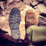
Using GE to plot off-trail hiking is inviting disaster. I have been on ankle-breaking terrain so rough that it tore the sole off one of my boots, and these were high quality Chippewa boots.
vastterrain
Full Member
- Joined
- Sep 1, 2012
- Messages
- 109
- Reaction score
- 181
- Golden Thread
- 0
- Primary Interest:
- All Treasure Hunting
Once again, GE does not give you any idea of what to expect on the ground or how difficult a path is going to be. GE should not be used for anything other than identifying landmarks or placement, or an attempt to correlate locations to determine a pattern. I never use GE to "plot a course" and neither should anyone else. The best thing to use is a hiker's guide, and Jack Carlson's is pretty good. And even then, that will only help you with on-trail hiking.
Using GE to plot off-trail hiking is inviting disaster. I have been on ankle-breaking terrain so rough that it tore the sole off one of my boots, and these were high quality Chippewa boots.
View attachment 1397255
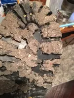
Danner Desert TFX.....You will never need another pair of boots !

sdcfia
Silver Member
Danner Desert TFX.....You will never need another pair of boots !
View attachment 1397273
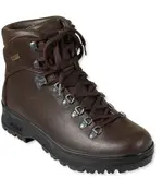
I had a pair of Danners once. They were pretty good. They could be re-soled then, but the vulcanized soles are much better now than the old Vibram soles were, IMO. The thing I didn't like about my Danners was the Denier panels, which were too often penetrated by various sharp things. I'm a big fan of one-piece, thick, all-leather uppers. Started with Red Wing Irish Setters, and switched to Italian boots sold by Cabelas and LL Bean. These are my currents:
sdcfia
Silver Member
Using GE to plot off-trail hiking is inviting disaster. I have been on ankle-breaking terrain so rough that it tore the sole off one of my boots, and these were high quality Chippewa boots.
View attachment 1397255
I bet that was a surprise.
anzayounggun
Jr. Member
- Joined
- Mar 16, 2015
- Messages
- 42
- Reaction score
- 57
- Golden Thread
- 0
- Location
- state of jefferson
- Detector(s) used
- bounty hunter (For Now)
- Primary Interest:
- All Treasure Hunting
Once again, GE does not give you any idea of what to expect on the ground or how difficult a path is going to be. GE should not be used for anything other than identifying landmarks or placement, or an attempt to correlate locations to determine a pattern. I never use GE to "plot a course" and neither should anyone else. The best thing to use is a hiker's guide, and Jack Carlson's is pretty good. And even then, that will only help you with on-trail hiking.
Using GE to plot off-trail hiking is inviting disaster. I have been on ankle-breaking terrain so rough that it tore the sole off one of my boots, and these were high quality Chippewa boots.
View attachment 1397255
Just a observation but this is the reason no body that uses boots professionally everyday for work uses Chippewa boots. Ie wildland firefighters. Loggers, hikers ECT. White's or Drew's hands down best boot for the money with le sportiva in a close second. They are expensive but completely worth the money. And completely rebuildable. Been hiking all over tons of s****y ground with mine and the are fine.
wrmickel1
Bronze Member
- Joined
- Nov 7, 2011
- Messages
- 1,854
- Reaction score
- 1,400
- Golden Thread
- 0
- Location
- Jamestown ND
- Detector(s) used
- Garrett 2500
- Primary Interest:
- Other
Personally I think these are all bad choices, There all a basic workbook, or a trail boot. In the terrain such as the Supers or the Rockies a more important part of a boot is to keep your ankles and feet dry and in good health, you need your feet to make it out. All leather with a raised back heel to keep your foot in a more natural position all day long. You'll be amazed at how your feet feel after a long trip in this rugged terrain.
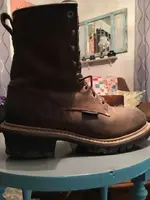
Wrmickel1

Wrmickel1
Last edited:
wrmickel1
Bronze Member
- Joined
- Nov 7, 2011
- Messages
- 1,854
- Reaction score
- 1,400
- Golden Thread
- 0
- Location
- Jamestown ND
- Detector(s) used
- Garrett 2500
- Primary Interest:
- Other
wrmickel1
Bronze Member
- Joined
- Nov 7, 2011
- Messages
- 1,854
- Reaction score
- 1,400
- Golden Thread
- 0
- Location
- Jamestown ND
- Detector(s) used
- Garrett 2500
- Primary Interest:
- Other
Just to mention if the trails are all your after do not buy this type of boot. There for off road. Extreme hiking!
Wrmickel1
Wrmickel1
anzayounggun
Jr. Member
- Joined
- Mar 16, 2015
- Messages
- 42
- Reaction score
- 57
- Golden Thread
- 0
- Location
- state of jefferson
- Detector(s) used
- bounty hunter (For Now)
- Primary Interest:
- All Treasure Hunting
And the one's built of quality will have brass screws placed in to the sole.
View attachment 1397475
Wrmickel1
That's why I said Drew's and White's. I have hiked miles upon miles in these boots on volcanic beds and desert terrain plus wet soggy norcal forests. Best boots all leather raised heel and made for hard work
sdcfia
Silver Member
Just a observation but this is the reason no body that uses boots professionally everyday for work uses Chippewa boots. Ie wildland firefighters. Loggers, hikers ECT. White's or Drew's hands down best boot for the money with le sportiva in a close second. They are expensive but completely worth the money. And completely rebuildable. Been hiking all over tons of s****y ground with mine and the are fine.
My exploring buddy swears by the Whites boots. Yes, they are rebuildable (welted soles, allowing for replacement) - which I used to do with my Red Wings (two additional sets of Classic Vibrams before a new pair of boots was necessary) - but I still favor the vulcanized soles, especially with a Gore-Tex liner in the boot. Good Merino wool socks, good boots, and you're in business. Spend more than you should on footwear - you'll be glad you did.
wrmickel1
Bronze Member
- Joined
- Nov 7, 2011
- Messages
- 1,854
- Reaction score
- 1,400
- Golden Thread
- 0
- Location
- Jamestown ND
- Detector(s) used
- Garrett 2500
- Primary Interest:
- Other
I agree, Your feet take you in
Your feet take you out.
Your feet take you out.
deducer
Bronze Member
I bet that was a surprise.
I had just gotten back on the Bluff Spring trail, heading south for the Peralta trailhead when the sole broke loose. I didn't have duct tape so I tore the rest of it off. Dumb move as I then saw that there was a nasty thunderstorm speeding right for the Supers, aiming for the Barkley basin. I hobbled down as fast as I could, and if you have been on the last part of Bluff Spring trail that goes to the Peralta trailhead, you know it's a pretty steep descend. I made it just as the heavy raindrops started pelting me- photo below was taken as I drove away from the trailhead.
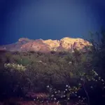
Last edited:
Similar threads
- Replies
- 4
- Views
- 334
Users who are viewing this thread
Total: 1 (members: 0, guests: 1)


