New VirtualEarth Imagery Sets !!!

pcolaboy

Hero Member
Sep 5, 2006
916
14
Pensacola, Fl
Detector(s) used
Minelab Explorer XS
Have any of you checked out the hi-res imagery available on Microsoft's Virtual Earth lately? Forget Google Earth.

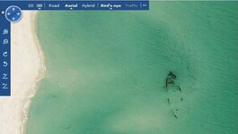
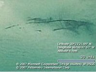
Maybe I'm slow getting on the bandwagon or the imagery has just now been made available for my area. Check out the shots of this wreck I found off Santa Rosa Island. This wreck has been known to exist for years but it will go through several years of being buried by the sand then uncovered by storms at certain times.
wreck2.JPG
North is Up(note the scale)

wreck1.JPG
North is Left

Keep in mind to get the hi-res imagery, you have to choose the Bird's Eye selection. It's MUCH easier if you go ahead and download the 3D add-on which lets you pan out to a wider angle making the imagery selection easier.

Enjoy,

Pcolaboy
 

Scott,

That is pretty amazing! The resolution is fantastic.

Thanks for the heads up.
 

Robert...

I was hoping you would see this ;D In fact I'm currently checking out your area and the hi-res is in most of your coastal areas as well.

Yippeee :D
 

MichaelB said:
Pcola, what is the cost for this service? I didn't see a free version.

Thx.

MichaelB

It's definitely free. Go to www.virtualearth.com and it will redirect you to the standard Microsoft Live Maps web page. There is selection on the map that says 3D. If you click on it, it should prompt you to download and install the add-on. Keep in mind it doesnt have all of the nice GPS waypoint capability as Google Earth but you can put a push pin mark on a spot and save it. When you're in 3D mode, the coordinates will appear on the screen only where your mouse is currently pointing. I havent found the capability to automatically save the coordinate information but a pen and paper work just fine.

Pcolaboy
 

I should have also mentioned that if the image you look at in Birds Eye mode isnt exactly as clear as you might like, you can try the rotate feature which will find a corresponding image "tile" that would have been made from a different angle during a different satellite pass. It's truly an amazing capability.
 

I found it. The images inland in Baldwin County are from 1994. The Tax Map Editor has given me the best up to date images so far. I bet Escambia County has the same site.

MichaelB
 

MichaelB said:
I found it. The images inland in Baldwin County are from 1994. The Tax Map Editor has given me the best up to date images so far. I bet Escambia County has the same site.

MichaelB

The standard 2D images in my area are very dated, but when you switch over to birds-eye mode, they are from this past spring. I'm sure of this because of a few construction projects I'm familiar with on Pensacola beach as well as my own home in Pensacola itself. Keep in mind though, if Bird's Eye is grayed out it usually means that it isnt available in the immediate area where your pointer is located. It does seem to take a while to cache the images onto the computer before it reacts so you may want to experiment a bit.

Pcola
 

pcolaboy said:
Robert...

I was hoping you would see this ;D In fact I'm currently checking out your area and the hi-res is in most of your coastal areas as well.

Yippeee :D

Hey, if you look close, I am waiving at you!

Let me know when you find something in my area!
 

Re: Virtual Earth imagery.

Be aware that Uncle Bill Gates made a deal with Pictometry Intl. to purchase a split price with all counties in the U.S.A. who would agree to the oblique photography shot by Pictometry for that county. Here in Brevard we did that and saved about $150,000.00 for a complete set of orthos at one foot and the majority of the county at 4 inch pixel resolution. You see the oblique photos in Virtual Earth as the "Birds Eye" view. I am mosaicing the 4 inch ortho photography now for re-sale in MRSID format. Virtual Earth does NOT host the 4 inch ortho photography and you will find it a little difficult to print the images in your browser. You will need some sort of software to capture the viewport (or use PrtScrn and after edit with something like PaintShop Pro, ect.)

Meanwhile, examine the photography in Virtual Earth very closely from the Birds Eye view because the orthos in Virtual Earth did NOT come from Pictometry... per USGS, EoSAT, and others. The Birds Eye view is usually shot originally with 4 inch pixels in most coverage and it is absolutely amazing what you can see! Just remember that you may easily see something in Birds Eye that you can NOT see in ortho view (direct overhead view or "nadir" view). You can not zoom in to the full resolution that Pictometry provides to the county clients while using Virtual Earth, but you can still get pretty close!

A very few counties have put the whole set of Pictometry photography online at high resolution. Duval County comes to mind... Jacksonville, Florida.

I think that Brevard, Indian River and St. Lucie have participated in this venture so far in 2007. Obviously the panhandle and many counties on the West Coast of Florida are in the same group as well. Great!!

Google Earth an Virtual Earth are running neck and neck. Just has to get better all the time!
 

signumops said:
Re: Virtual Earth imagery.

Meanwhile, examine the photography in Virtual Earth very closely from the Birds Eye view because the orthos in Virtual Earth did NOT come from Pictometry... per USGS, EoSAT, and others. The Birds Eye view is usually shot originally with 4 inch pixels in most coverage and it is absolutely amazing what you can see! Just remember that you may easily see something in Birds Eye that you can NOT see in ortho view (direct overhead view or "nadir" view). You can not zoom in to the full resolution that Pictometry provides to the county clients while using Virtual Earth, but you can still get pretty close!

That's pretty much why I started this thread to begin with.
 

signumops said:
Re: Virtual Earth imagery.


Meanwhile, examine the photography in Virtual Earth very closely from the Birds Eye view because the orthos in Virtual Earth did NOT come from Pictometry... per USGS, EoSAT, and others. The Birds Eye view is usually shot originally with 4 inch pixels in most coverage and it is absolutely amazing what you can see! Just remember that you may easily see something in Birds Eye that you can NOT see in ortho view (direct overhead view or "nadir" view). You can not zoom in to the full resolution that Pictometry provides to the county clients while using Virtual Earth, but you can still get pretty close!

Quality is amazing. I used VE when I was buying my house and saw that there was several huge trees right in my front yard that were taken down in between the time the planes captured the images and when I bought it!
 

it deinitely has it's place..but....all that is seen as what is above water, of course. So, is this something to use in very remote locations where no one is there to see it personally?
..say, on a cay in the middle of nowhere? Just want to l]know...\ \
thanks....fortunate
 

Having had my fill of Gates crap and switched to Apple, do ya think I can still access this, or do you have to have Explorer as a browser? Sign, do you Think Martin county will join her neighbors in the mapping thing? We do have a really good GIS website now, but not as detailed along the coast as I'd like.
 

Hey billinstuart:
Martin Co. is generally on top of the GIS issue. I have worked with their crew in years past and they have a tax base permitting them to handle these sorts of technologies.

I am sure that they will get the oblique data eventually. However, if they bought it this year, it would be available on Virtual Earth. Otherwise, the dataset is monsterous and almost impossible for a county to host by itself (Duval did it, but the file downloads are immense...does work though). It is used primarily by police, emergency services, ect., and for property inspection/appraisal.

If they get it next year, I don't know if the Microsoft deal will still be in effect (probably will).
Don't personally know if the IE browser on the Apple platform can use Virtual Earth, but I would assume that it can.

Signumops sends
 

With the high prices of fuel and all the budget cuts within the gov,they prolly hired a amateur photog with a ultralight to shoot the crappy pics.Your tax dollars at work!
 

Actually, these shots are fully geo-rectified and ready for mosaicing if desired, unlike their cousins shot after Jeanne and Charley in 2004, and, the pixel resolution is fully equal to anything on Virtual Earth... in fact, probably better (oblique shots in Virtual Earth come from Pictometry and their cameras resolve to around .33 foot, or about 4 inches: these shots are even at higher resolution). I hope that NOAA does this for Ike if it hits the Keys. They ended up shooting some pretty astonishing oblique photos of the lower Keys after Georges, but, not many people were aware of it.
 

Any updates on this wreck? I got to fly over it in a tourist helicopter and got some video but there were a lot of waves so it didn't turn out that good. The people running the sightseeing tour had some photos where one had shown what looked like either a cannon or mast but couldn't make it out.
 

Top Member Reactions

Users who are viewing this thread

Back
Top