NorCal Rains 2017
NorCal Rains,
The USGS water flow data chart shows that about midnight of the morning of the 9th the NFAR peaked at 45,000 CFS and then slowly fell back down. This morning shows the flow curve heading back up, how far will it go

?
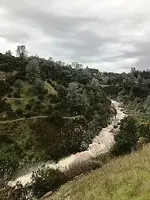
The pictures of the "usually dry" creek shown above depict a Raging White Water Death Trap with very large waves capable of moving and or undermining anything in its path and this is a 'Creek'. As the storm continues feeding creeks & rivers these drainages will be changed dramatically and the damage to man made objects, roads/bridges/buildings, will likely be significant.
One must also consider that any small water traps will also be swollen with water, water traps like mountain trails. Any foot travel that has cut between trail switchbacks will, during this storm, be prone to washing out sections of the trail and that is why folks should use the trail and not make shortcuts. Things will be different out in our zones of investigation, I expect some trails to be damaged if not washed away. Any landmarks we've used along the rivers may very well be gone when our season starts back up. We will need to be careful to insure we have safe footing as just about everything will have been moved and could be unstable.
It will be interesting to see the effects of all of this rain as Stuff has been moved!....................63bkpkr

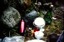
March 1974 3 days in the rain: Green Valley Trail on the high bank, Alta side of the NFAR. Taken under a clear plastic tarp so contrasts are quite nice. The river was running strong and we never got any closer to it than the outer edge of the river. Just to the left of this picture is the grassy spot with the spring bubbling up out of the ground.


 exact coordinates please
 ?
?

