Oak Island the Strange, the Bizarre, and Maybe the "Truth!

OP
OP
Robot

Robot

Bronze Member
Mar 10, 2014
2,014
1,709
Primary Interest:
Other
JM...Could it have been a hand signed autograph of?...Jayne Mansfield!

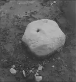
Could the so called "90 foot Stone " the guys found actually be a replica ? Attached is a short article which has an eye witnesses state that the initials JM had been carved into the stone. Just food for thought:

https://ciphermysteries.com/2017/03/19/oak-island-ciphers-part-1-80-foot-rock-cipher

More to the suspicion of...JM...Jotham McCully!

Person
Authorized form of name

McCully, Jotham
Description area

Dates of existence

1819-1899
History

Jotham Blanchard McCully was born on 19 January 1819, the son of William McCully and Elizabeth (Arnold) of Debert. He resided in Truro and married Isabelle McConnell on 27 July 1844; they had 10 children. He is believed to have been an engineer by profession, and was involved in several attempts to locate treasure on Oak Island in the mid-19th century. In 1845 he became manager of operations of the Truro Company, formed to raise money for the treasure hunt by selling shares. The company began digging in 1850, but by 1851 had run out of funds and ceased operations. In 1861 McCully was corporate secretary of the newly-formed Oak Island Association of Truro, which was able to raise a large sum of money. With a work force of 63 men and 33 horses, the Association made several attempts to solve the problem of water flooding in the “money pit”. McCully wrote of these attempts in the Liverpool Transcript, 16 October 1862. The work was unsuccessful, however; the money ran out and the company folded in 1864. In 1866 McCully participated in a third company, the Oak Island Eldorado Company [Halifax Company], which again raised funds and continued operations. But it also failed and closed down in 1867. McCully died in Truro on 9 September 1899 at age 80

He of all people had the greatest access to this Stone!
 

franklin

Gold Member
Jun 1, 2012
5,036
7,168
Detector(s) used
Garrett ADS-7X, Fisher Two Box M-Scope, Mother Lode Locator, Dowsing Model 20 Electroscope, White's TM808, White's TM900, Inground Scanners
Primary Interest:
All Treasure Hunting
The problem today with any Shut Off Valve being able to close off any Flood Tunnels is what has happened to the area around the Money Pit Shaft.

The area has been perforated by many numerous shafts.

All or most would allow water to by pass!

Yes but the treasure is not under the money pit. The money pit was only the entrance to the mines.
 

OP
OP
Robot

Robot

Bronze Member
Mar 10, 2014
2,014
1,709
Primary Interest:
Other
Yes but the treasure is not under the money pit. The money pit was only the entrance to the mines.

Thank Goodness!...The Depositors...had a Back-Up Plan!

The Depositors did plan on Tunnels running from The Money Pit Shaft...Or...running Near to the Money Pit Shaft...as per The Buzzard!
 

Last edited:

will7782

Full Member
Dec 28, 2018
129
90
Primary Interest:
All Treasure Hunting
shutoff valve could be as simple as blocking a tunnel. knowing about the tunnel and where it is would be the secret.

money pit site could be any number of things. a ruse, a part od tunnel system that I am yet to comprehend, os, as many here say, a mistake.
 

Charlie P. (NY)

Gold Member
Feb 3, 2006
13,004
17,107
South Central Upstate NY in the foothills of the h
Detector(s) used
Minelab Musketeer Advantage Pro w/8" & 10" DD coils/Fisher F75se(Upgraded to LTD2) w/11" DD, 6.5" concentric & 9.5" NEL Sharpshooter DD coils/Sunray FX-1 Probe & F-Point/Black Widows/Rattler headphone
Primary Interest:
Metal Detecting
You still have to lift that volume of water above your pit mouth and channel it far enough away it doesn't come back in.

Very impractical for the effort for pre-combustion engine technology. Why bother? Answer: they didn't.

I'm still favoring my original Natural Glacial sink-holes with occasional storm debris as the sea level rose in the last 10,000 years.
 

Last edited:
OP
OP
Robot

Robot

Bronze Member
Mar 10, 2014
2,014
1,709
Primary Interest:
Other
How Would A 20 Ton Boulder Have Been Moved?...In Smith's Cove?...Dan Blankenship!

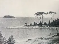
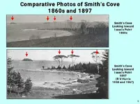
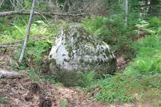
I believe all prior pictures showed this Stone (as I refer to as Stone 2 or Stone A) to be located dead center in Smith's Cove.

Stone - Smith's Cove.jpg Stone Smith's Cove 5.jpg

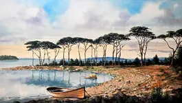
Texas Watercolor Artist Robert W. Cook creates realistic paintings that embrace a variety of subjects including urban landscapes, old buildings, classic cars, and serene get-away places to get lost in. Bob is a signature member of the National Watercolor Society and the Society of Watercolor Artists. His original paintings are usually outdoor settings, old and new architecture, weathered structures, and images that keep us in the present or transport us back to a time long passed.

Stone smiths-cove-robert-w-cook.jpg

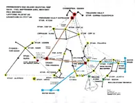
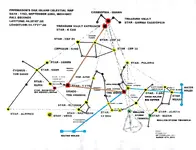
Stone 2 (Star Merak)was in transit with Stone 1 (Star Kochab), acting as the Water Tunnel's bearings, towards the Money Pit.

Freemason's Celestial Map March 2018.jpg

It appears from pictures today that this Stone is now located off to the side.

Stone Smiths Cove.jpg Stone Smith Cove 2.jpg


Could this Stone have been moved when Dan Blankenship excavated the Cove looking for the Flood Tunnel Entrances and finding what he believed was a Hidden Wharf?

Lets hope his memory is still good as to where this Stone's original location was.

Maybe, Fred Nolan's Survey Charts could show Stone 2's true location!
 

Last edited:

Stretch Da Truth

Bronze Member
Jan 13, 2017
1,038
1,097
Detector(s) used
XP DĂ©us & a Carrot!
Primary Interest:
Metal Detecting
" Could this Stone have been moved when Dan Blankenship excavated the Cove "

This is one of the biggest issues here at OI.
200 +years of people digging, blasting, moving, keeping, burying this, that and the other that no map, marker or images are relevant anymore as this whole place is a mess.
 

OP
OP
Robot

Robot

Bronze Member
Mar 10, 2014
2,014
1,709
Primary Interest:
Other
" Could this Stone have been moved when Dan Blankenship excavated the Cove "

This is one of the biggest issues here at OI.
200 +years of people digging, blasting, moving, keeping, burying this, that and the other that no map, marker or images are relevant anymore as this whole place is a mess.

I believe it was!

But, with other Stone Markers within my Celestial Star Map, I can replace it back to its original location.
 

will7782

Full Member
Dec 28, 2018
129
90
Primary Interest:
All Treasure Hunting
You still have to lift that volume of water above your pit mouth and channel it far enough away it doesn't come back in.

Very impractical for the effort for pre-combustion engine technology. Why bother? Answer: they didn't.

I'm still favoring my original Natural Glacial sink-holes with occasional storm debris as the sea level rose in the last 10,000 years.

I could easily name dozens of things that were done/built in times long past that could be considered "impractical". Pyramids are at the top of that list. I've not been to Egypt, but am convinced that they do indeed exist. their technology also predated the combustion engine.

Unlike you and others, I am not trying to convince you that my OPINION is correct, and that your OPINION is wrong. I find it quite plausible that hiding something in that swamp would work. Mother Nature has created many wonders, so I cannot flatly discount the idea that sink holes played a part.
 

OP
OP
Robot

Robot

Bronze Member
Mar 10, 2014
2,014
1,709
Primary Interest:
Other
I'll Take The High Road!

I could easily name dozens of things that were done/built in times long past that could be considered "impractical". Pyramids are at the top of that list. I've not been to Egypt, but am convinced that they do indeed exist. their technology also predated the combustion engine.

Unlike you and others, I am not trying to convince you that my OPINION is correct, and that your OPINION is wrong. I find it quite plausible that hiding something in that swamp would work. Mother Nature has created many wonders, so I cannot flatly discount the idea that sink holes played a part.

The Money Pit Shaft was constructed on the highest point of the island.

The flooding started at the 90 foot level of the shaft.

Like my speculation for the Jesuit's water trap in the series The Treasure of Sacambaya, all the Jesuits had to do to retrieve their treasure was open a hole below the water level and drain their Treasure Shaft.

With the digging already at Smith's Cove, it was stated by Irving that more water is coming back to the Coffer Dam, from the ground above, than from the Ocean.

Once more digging is done, I would "speculate" that more water may be draining from the top shafts and the ground above.

One should check to see if the water in Borehole 10X is now gone!

This action may even drain the Swamp and...Money Pit Shaft...Once Again!

Oak Island Height.jpg
 

Last edited:

n2mini

Hero Member
Jan 7, 2015
983
513
Triad NC
Primary Interest:
All Treasure Hunting
Too bad back in the mid 60's when Fred Nolan was surveying the island he didn't get the Original Money Pit documented.. and points of high and low water line, which has changed alot over the years..
 

Stretch Da Truth

Bronze Member
Jan 13, 2017
1,038
1,097
Detector(s) used
XP DĂ©us & a Carrot!
Primary Interest:
Metal Detecting
I believe it was!

But, with other Stone Markers within my Celestial Star Map, I can replace it back to its original location.

How many of the original stones and markers that are now missing or moved can you track and replace?
 

Stretch Da Truth

Bronze Member
Jan 13, 2017
1,038
1,097
Detector(s) used
XP DĂ©us & a Carrot!
Primary Interest:
Metal Detecting
Too bad back in the mid 60's when Fred Nolan was surveying the island he didn't get the Original Money Pit documented.. and points of high and low water line, which has changed alot over the years..

If Fred has surveyed the MP way back, all the info would still be available not all this guess work and crackpot theory followups.
And all would have been over in season 1. :occasion14:
 

OP
OP
Robot

Robot

Bronze Member
Mar 10, 2014
2,014
1,709
Primary Interest:
Other
On Oak Island...You Cannot Throw A Rock...Without Hitting A Stone!

How many of the original stones and markers that are now missing or moved can you track and replace?

I could replace them all...the slow way...the same way the original Depositors created them.

But, just from photos and from Marker Stones still in place on the island (Nolan's Cross Marker Stone and the recently found Center Marker Polaris Stone), I could begin realining them up and inserting any missing Stone Markers.

nolan cross (1).jpg Oak Island - drilled_stone.png Granite boulder.jpg Oak Island 1936 (1).JPG fred-nolan-map.jpg

This would all require access to the island...access to Fred Nolan's Survey Map...and maybe...A TV Appearance...LOL?
 

franklin

Gold Member
Jun 1, 2012
5,036
7,168
Detector(s) used
Garrett ADS-7X, Fisher Two Box M-Scope, Mother Lode Locator, Dowsing Model 20 Electroscope, White's TM808, White's TM900, Inground Scanners
Primary Interest:
All Treasure Hunting
I could replace them all...the slow way...the same way the original Depositors created them.

But, just from photos and from Marker Stones still in place on the island (Nolan's Cross Marker Stone and the recently found Center Marker Polaris Stone), I could begin realining them up and inserting any missing Stone Markers.

View attachment 1668555 View attachment 1668556 View attachment 1668558 View attachment 1668559 View attachment 1668560

This would all require access to the island...access to Fred Nolan's Survey Map...and maybe...A TV Appearance...LOL?

If you can do all of that? Then you can tell them exactly where the "money pit" is located and all of the other bore holes?
 

OP
OP
Robot

Robot

Bronze Member
Mar 10, 2014
2,014
1,709
Primary Interest:
Other
I Always Say...Put Up Or Shut Up!

If you can do all of that? Then you can tell them exactly where the "money pit" is located and all of the other bore holes?

For a long time...that is what I have been Saying and Showing!

From my early Celestial Star Map to its now Revised, March 2018 Edition, I show where Celestial Stars have created Terrestrial Stone Markers for the Money Pit, Treasure Vault, and Tunnels, along with what I believe is Bacon's Tomb location.

I do not have locations such as Bore Holes, created after the Depositor's 1762 formation of this Map.

Freemason's Celestial Map March 2018.jpg
 

Last edited:

Stretch Da Truth

Bronze Member
Jan 13, 2017
1,038
1,097
Detector(s) used
XP DĂ©us & a Carrot!
Primary Interest:
Metal Detecting
I could replace them all...the slow way...the same way the original Depositors created them.

But, just from photos and from Marker Stones still in place on the island (Nolan's Cross Marker Stone and the recently found Center Marker Polaris Stone), I could begin realining them up and inserting any missing Stone Markers.

This would all require access to the island...access to Fred Nolan's Survey Map...and maybe...A TV Appearance...LOL?

I will give the boys a call and get you in. I would rather watch you do that and possible make some progress than hear more kookie Templar theories and other tom fool-erie.
 

franklin

Gold Member
Jun 1, 2012
5,036
7,168
Detector(s) used
Garrett ADS-7X, Fisher Two Box M-Scope, Mother Lode Locator, Dowsing Model 20 Electroscope, White's TM808, White's TM900, Inground Scanners
Primary Interest:
All Treasure Hunting
Well myself I have seen three different "Star Charts" Petter Admundsen had the first, then Robot had his here on treasurenet and the then the astro-engineer or whatever his title. As far as all the adjustments for the time and place Petter Admundsen's seems to me to be the most accurate. Sorry.
 

OP
OP
Robot

Robot

Bronze Member
Mar 10, 2014
2,014
1,709
Primary Interest:
Other
Is It To Be...Door Number One...Door Number Two...Or Will It Be... Door Number Three!

Well myself I have seen three different "Star Charts" Petter Admundsen had the first, then Robot had his here on treasurenet and the then the astro-engineer or whatever his title. As far as all the adjustments for the time and place Petter Admundsen's seems to me to be the most accurate. Sorry.

You Choose!

Please show me Amundsen's Star Chart!
 

Last edited:

franklin

Gold Member
Jun 1, 2012
5,036
7,168
Detector(s) used
Garrett ADS-7X, Fisher Two Box M-Scope, Mother Lode Locator, Dowsing Model 20 Electroscope, White's TM808, White's TM900, Inground Scanners
Primary Interest:
All Treasure Hunting
Petter Amundsen was on their show a couple of years ago. Maybe you can look back through their episodes. He does have some blogsites on the Internet.
 

Top Member Reactions

Users who are viewing this thread

Top