There's only a few ways to calculate position. GPS uses triangulation, this claims to use bearing and distance from a floating 'base station', and it can use an acoustic signal for a distance, but it has to use something for a bearing. Do you know what that is? My guess is magnetic, suitable for short local distances.
The pinger is omni-directional. Once a path is recognized as a return ping, the bearing and distance are calculated according to the northline established by the GPS... no compass magnetics involved, I would assume. Ping return speed would determine the distance the base station is from the rover. Enhanced WWII sonar principal.
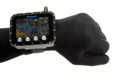
I just put my Magellan Waas enabled GPS in a clear, waterproof Otter case and float it on the surface above me. When I find something interesting, I pull the GPS uderwater and record the coordinates on a dive slate. Certain GPS units will retain their last coordinates after they lose their satelite signal.
Well, I am a little skeptical of the claims.
I can see its set up with a GPS gateway, with a pinger system. I just cant see it being that accurate with only a single pinger, that should only give you distance....
I would also be curious on the noise level, is the ranging constant? That could be very annoying....
As for the GPS unit, the otter case is an interesting idea, just set it to track,
but pulling a line down or dragging a line, with something bobbing on the surface?