Cochetopa
Jr. Member
- Joined
- May 2, 2009
- Messages
- 65
- Reaction score
- 23
- Golden Thread
- 0
- Location
- Galt's Gulch, Colorado
- Detector(s) used
- Minelab Eureka Gold
- Primary Interest:
- Prospecting
- #1
Thread Owner
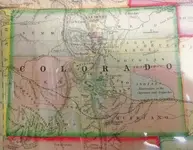
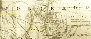
Sounds like a nice antique show to attend. You see any good buys? I take it you took the name you use is for the Cochetope pass? I took this picture of a 1861 map of Colorado where they spell Cochetope with two O's as "Coochetope"... I'm still wondering what the early folks ever called the trail lined out that went over Cochetope pass on this old original map. The old map was produced before the town of Leadville, Colorado existed, but marks the location of Oro City the placer mining town that proceeded Leadville. RGINN can see how big Summit County once was.
What I mean there Choch! is on the map I posted there is a dash dot line from the east border going in to Bent's Fort and exiting to the west at the Colorado River, then called the Grand River of this marked trail of this 1861 Colo. map. I've read of this trail that goes over the summits San De Cristo and Cochetopa passes, but I can find nothing of that path across Colorado ever given a name??, such as the Cimarron (not on the map) or Santa Fe trails. I have read that this overland trail was a consideration of the first transcontinental RR. and J C Fremont did explore and survey the possibility of it being a RR over the Rockies to California.There were no bargains at the antique show, but most vendors were willing to dicker over price. Popular items for sale were: miner’s candle stick holders, miner’s lamps and empty blasting cap boxes. All were priced $100+ depending on condition. I saw a blasting cap box in really nice condition sell for $100, asking price was $150. There was a fine arts painter who paints in a photo-realistic style and who had 6 of her still life works with a western mining theme on sale. One was already sold for $2200 when I had arrived, and a 2[SUP]nd[/SUP] had sold for $2300 by the time I left.
This is what I have learned about Cochetopa. It is an Indian word meaning “buffalo emerging”. Cochetopa Pass used to be a super highway for bison migrating between summer time high country grazing in the Gunnison area, and their winter time grounds in the San Luis Valley. By “lined out” I take to mean clearly visible. I can visualize the trampling hooves of bison churning up the terrain as they moved from one seasonal pasture to another. The pass route must have appeared plain as day by just following the animals’ tracks.
10-4 on that. I read Bayou Salado many years ago. I think I had the book at one time. I so enjoyed exploring that place back when I lived in bv.More than one Jefferson, tamrock. According to a book I have, Bayou Salado: The Story of South Park (great reference book) Jefferson City, or Jefferson Diggings came into existence in 1860 at the foot of Georgia Past ne of Tarryall. About 2,000 gold prospectors lived and worked the area around there. It's the only town shown in South Park on some 1860-61 maps. It lasted 3 or 4 years. In 1865 two towns started as a real estate venture combined to be called Jefferson. It was intended to be a commercial and distribution center. After that fizzled, the present day Jefferson started up in 1879 at the same location, which is a few miles southeast of the original Jefferson City location.