Tom_Restorer
Gold Member

...
remembers me to this one.
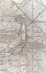
So much about "treasure map´s doesn´t exist" or "an X never marked a treasure spot"...
Map of the Whydah, made after it sunk -


Hey, I've been there!! That's just a skip and half a hop from where I was stationed.

Is that why they call 'em Crappies??


Bill, Happy hunting! I hope you find some great Canadian history!
WD,
I like your highway signs....lol.
Well it's a seeded hunt on the beach and since I'm admin on the forum I'll be helping out rather than detecting but it should be fun just the same. It'll give me a chance to socialize with some of the members.
Regards + HH
Bill



Making 22 kts, 1ft seas, 4 kt wind out of the east, heading 73 degrees magnetic with a final destination of beaufort N.C. life is good what a gorgeous travel day. Normaly we see alot of sea life on this leg of the trip. We will cut through the frying pan shoal today. Many a ship has met its doom there. I have a good permission in this town with much civil war era stuff, and even stuff dating back to the early 1700s. Hope I have time for it.
Yes sir RTR, sure will !! Black beards final stand !!

Thank you sir. Appreciate the sentiment....ya ol' fool you!Hope you feel better keith, good to see you in posting !!