What's new

Remote targeted prospecting

Mrasolii

Tenderfoot
Joined
Nov 28, 2025
Messages
3
Reaction score
3
Golden Thread
0
Hello everyone,

I would like to introduce a method I have been developing for identifying areas that may deserve further investigation.

The basic idea is to combine careful analysis of aerial/satellite imagery, visible environmental features, terrain patterns, and on-site observations in order to make a preliminary prediction about specific locations.

I am not asking anyone to simply accept my conclusions. Instead, I would like the method to be tested objectively.

My proposal is straightforward: I can identify and mark a specific area on an aerial image or map, and then the location can be independently checked using a metal detector or other appropriate equipment. The purpose is to see whether my predicted areas show a meaningful and repeatable correlation with actual detector responses.

My goal is not to make extraordinary claims without evidence. I am interested in testing, documentation, repeatability, and constructive criticism.

If experienced detectorists or researchers are interested, I would be happy to discuss the method, explain the testing conditions, and receive honest feedback.

I believe that a method should ultimately be judged by controlled testing and repeatable results, not by claims alone.

Thank you, and I look forward to hearing your thoughts.
 
Upvote 0
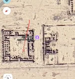
Here is an example of my method. I marked the specific area of interest directly on the aerial image. According to my analysis, this location should produce a strong response during field testing. I would be interested in seeing the results of an independent test.
 

Attachments

  • IMG_20261113_113152_218.webp
    IMG_20261113_113152_218.webp
    92.1 KB · Views: 6
Mrasolii,

I can share extensive experience on the subject. I have been active in remote prospecting here and elsewhere for many years. The science surrounding remote detection is a very mature science at this point in history.

You have laid out a description of a "method"...

In your words,

"The basic idea is to combine careful analysis of aerial/satellite imagery, visible environmental features, terrain patterns, and on-site observations in order to make a preliminary prediction about specific locations."

You have shown an example...

"Here is an example of my method. I marked the specific area of interest directly on the aerial image. According to my analysis, this location should produce a strong response during field testing. I would be interested in seeing the results of an independent test." (image above)

The point of interest has "no contrast" in comparison to the surrounding area.

The problem as I see it:

Surface imaging in the visible spectrum is surface reflective only. You can only see the same image as myself or anyone else. There is no possible enhanced analysis of any measurable "quantity" or "quality" of that image.

Digital images have too many limitations. Imaging sensors have pixelation based on the number of individual imaging sensors "picture elements" in the imaging device and the area being imaged.

Your image is 140 pixels wide x 157 pixels high. I covers a an unknown area. It may be 300 meters wide and 300 meters high giving each picture element an area of about four square meters. A collective amount of pixels needed to discern a discrete object in the image needs enough combined elements for an observer to be able to "see" a unique characteristic.

- Geowizard
 
Mrasolii,

I can share extensive experience on the subject. I have been active in remote prospecting here and elsewhere for many years. The science surrounding remote detection is a very mature science at this point in history.

You have laid out a description of a "method"...

In your words,

"The basic idea is to combine careful analysis of aerial/satellite imagery, visible environmental features, terrain patterns, and on-site observations in order to make a preliminary prediction about specific locations."

You have shown an example...

"Here is an example of my method. I marked the specific area of interest directly on the aerial image. According to my analysis, this location should produce a strong response during field testing. I would be interested in seeing the results of an independent test." (image above)

The point of interest has "no contrast" in comparison to the surrounding area.

The problem as I see it:

Surface imaging in the visible spectrum is surface reflective only. You can only see the same image as myself or anyone else. There is no possible enhanced analysis of any measurable "quantity" or "quality" of that image.

Digital images have too many limitations. Imaging sensors have pixelation based on the number of individual imaging sensors "picture elements" in the imaging device and the area being imaged.

Your image is 140 pixels wide x 157 pixels high. I covers a an unknown area. It may be 300 meters wide and 300 meters high giving each picture element an area of about four square meters. A collective amount of pixels needed to discern a discrete object in the image needs enough combined elements for an observer to be able to "see" a unique characteristic.

- Geowizard
Thank you for your detailed and thoughtful response, Geowizard.

I should clarify that my method is not based on extracting hidden physical information from the pixels or visible spectrum of the aerial image. I agree with your point about the limitations of ordinary digital imagery.

My approach is different. I use the aerial image mainly as a visual reference while performing what I describe as a mental or intuitive form of remote targeting. In my personal experience, I use focused mental processes and what I believe may be related to brain-generated signals or responses to identify a specific area of interest.

I understand that this is not a conventional or established scientific detection method, and I am not presenting it as proven science. That is exactly why I am interested in objective, independent testing.

The important question, in my opinion, is not whether something unusual can be seen in the pixels, but whether the locations identified in advance can produce results at a rate significantly better than chance under properly controlled conditions.

I would welcome your thoughts on how such a test could be designed fairly and objectively.
 
Guys, he's just map dowsing.

Mrasolii, you don't need us to help you evaluate your powers. All you need to do is dowse your own targets, then grab a shovel and do your own digging. Then show us the gold. How much gold do you have so far?
 
You'd be better off going to the Subterrix site and doing your own research.
 

Users who are viewing this thread

Back
Top Bottom