
- #1
Thread Owner
Since we're trying to spot shipwrecks from google earth - how bout this one?
This definitely isn't in Texas... and hopefully I don't get laughed out of here by posting this... but I'm very inexperienced in what a true shipwreck should look like when viewed from Google Earth. So I saw this while perusing, and figured I'd post it for input. Please feel free to search the area around these islands for anything else yall see that might make more sense. First documented nautical activities I could find in the region began in early 1700s, but I'm sure they started well before that.
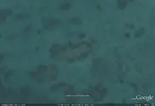
Heres what I thought might've been a potential wreck, due to the way the growth is around it. Dimensions appear to be about 150'x40'.
11 Degrees 44'06.95N
43 Degrees 10'20.41E
As always, thanks in advance for any help, criticism, or comments.
This definitely isn't in Texas... and hopefully I don't get laughed out of here by posting this... but I'm very inexperienced in what a true shipwreck should look like when viewed from Google Earth. So I saw this while perusing, and figured I'd post it for input. Please feel free to search the area around these islands for anything else yall see that might make more sense. First documented nautical activities I could find in the region began in early 1700s, but I'm sure they started well before that.
Heres what I thought might've been a potential wreck, due to the way the growth is around it. Dimensions appear to be about 150'x40'.
11 Degrees 44'06.95N
43 Degrees 10'20.41E
As always, thanks in advance for any help, criticism, or comments.



 I just look at the aerial photos and go dive something that looks interesting. There are many, many, more guys on here with actual salvage experience on old wrecks - I can only look and not touch. But I certainly appreciate the compliment!
















