BuffaloBob said:
Casca said:
Thanks Buffalobob. I have given up on getting anything that detailed. Any arizona, new mexico, or texas maps in that collection of yours?
Don't know off hand. But I will look through my collection of maps and routes and let you know. Most likely just schedules and timetables but maybe I can put a route on a map. Too many places, too little time!BB
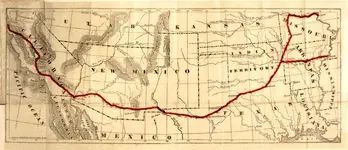
Well I found a list of all the stops. And a site with lot's of info. Here we go:
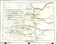
Divisions and Stations of the Route
East to West
Ninth Division — St. Louis, Mo., to Tipton
Eighth Division — Tipton to Fort Smith, Ark., and Memphis, Tenn., to Fort Smith
Seventh Division — Fort Smith to Colbert's Ferry, Okla.
Sixth Division — Colbert's Ferry to Fort Chadbourne, Texas
Fifth Division — Fort Chadbourne to Franklin (El Paso), Texas
Fourth Division — Franklin (El Paso) to Tucson, Ariz.
Third Division — Tucson to Fort Yuma, Calif.
Second Division — Fort Yuma to Los Angeles, Calif.
First Division — Los Angeles to San Fransisco, Calif.
MISSOURI STATIONS
Google map with the Missouri portion of the Butterfield Trail and related waymarks.
From St. Louis to Tipton, the mail was carried by the Pacific Railroad.
Tipton
Schackleford's Station
Mulholland's Station
Burn's Station
Warsaw
Bailey's Station
Quincy
Yoast's Station
Bolivar
Smith's Station
Evan's Station
Springfield
Ashmore's Station
Smith's Station
Crouch's Station
Harbin's Station
ARKANSAS STATIONS
Google map with the Arkansas portion of the Butterfield Trail and related waymarks.
Northwestern Route
Callahan's Station (near present-day Rogers)
Fitzgerald's Station (near present-day Springdale)
Fayetteville
Park's Station
Brodie's Station (Lee Creek)
Woolsey's Station (also called Signal Hill)
Van Buren
Fort Smith
Memphis Route
Memphis, Tenn.
Madison, Ark.
Des Arc
Atlanta (present-day Austin)
Cadron
Plumer's Station (Plummerville)
Lewisburg (near present-day Morrilton)
Hurricane
Pottsville Inn
Norristown (Russellville)
Dardanelle
Stinnett's Station
Paris
Charleston
Fort Smith
OKLAHOMA STATIONS
Google map with the Oklahoma portion of the Butterfield Trail and related waymarks.
Watson's Station (Skullyville)
Trahern's Station
Holloway's Station (Brazil Station)
Riddle's Station
Pusley's Station
Blackburn's Station
Waddell's Station
Geary's Station
Boggy Depot
Blue River Station
Fisher's Station
Colbert's Ferry
TEXAS STATIONS
Google map with the Texas portion of the Butterfield Trail and related waymarks.
Preston's Station
Sherman
Diamond's Station
Gainesville
Davidson's Station
Connolly's Station
Earheart's Station
Jacksboro
Murphy's Station
Fort Belknap
Franz's Station
Clear Fork Station
Smith's Station
Fort Phantom Hill Station
Mountain Pass Station (Abercrombie Pass)
Valley Creek Station
Fort Chadbourne
Colorado River Station
Grape Creek Station
Camp Johnston
Head of Concho Station
Llano Estacado
Mustang Waterholes
Initial Northern Route
Horsehead Crossing Station
Immigrant Crossing Station
Pope's Crossing
Delaware Springs Station
Pinery
Guadalupe Pass Station
Crow Spring Station
Cornudas de los Alamos
Ojos de los Alamos
Hueco Tanks Station
Franklin (El Paso)
Later Southern Route
Horsehead Crossing Station
Fort Stockton (Comanche Spring)
Hackberry Hole Station
Barrilla Spring Station
Limpia
Fort Davis
Barrel Spring Station
Deadman's Hole
Van Horn's Wells
Eagle Spring
Fort Quitman
Birchville Station
San Elizario
Socorro
Ysleta
Franklin (El Paso)
NEW MEXICO STATIONS
Google map with the New Mexico portion of the Butterfield Trail and related waymarks.
Frontera (Cottonwoods Station)
Fort Fillmore
Mesilla
Picacho Station
Rough and Ready Station
Goodsight Peak Station
Fort Cummings
Cooke's Spring
Murphy's Station
Cow Spring Station
Soldier's Farewell
Station near Deming
Station near Lordsburg
Stein's Pass Station
ARIZONA STATIONS
Google map with the Arizona portion of the Butterfield Trail and related waymarks.
Fort Bowie
Apache Pass Station
Dragoon Spring Station
Cienaga Station
Willcox's Station
Tucson
Pointer Mountain Station
Picacho Pass Station
Pima Village
Maricopa Wells
Gila Ranch
Murderer's Grave Station
Oatman Flat
Flapjack Ranch
Griswell's Station
Peterman's Station
Filibuster Camp
Swiveller's Ranch
Arizona City
Texas Hill Station
CALIFORNIA STATIONS
Google map with the California portion of the Butterfield Trail and related waymarks.
Fort Yuma
Pilot Knob Station
Mountain Springs Station
Cooke's Wells Station (present-day Mexico)
Gardener's Wells Station (present-day Mexico)
Alamo Mocho Station (present-day Mexico)
Monument Station
Indian Wells Station
Sackett's Wells
Carrizo Creek Station
Palm Spring
Vallecito Station
Box Canyon
Blair Valley
San Felipe
Warner's Ranch
Oak Grove Station
Aguanga Station
Temecula Station
Laguna Grande
Murrieta
Temescal Station
Corona
Chino Ranch
San Jose Station (Pomona)
El Monte Station
Los Angeles
Cahuenga Station
Los Encinos
Mission San Fernando
Hart's Station
King's Station
Widow Smith's Station
French John's Station
Reed's Station
Fort Tejon
Sinks of Tejon (Alamo Station)
Kern River Slough
Kern River Crossing (Gordon's Ferry)
Poso Creek Station (Posey Station)
Mountain House Station
Fountain Spring Station
Tule River Station
Lindsay
Packwood's Station
Visalia Station
Cross Creek Station
King's River Station
Elk Horn Spring Station
Hawthorne's Station
Fresno City
Firebaugh Ferry
Temple's Station
Lone Willow Station
San Luis Ranch
Pacheco Pass Station
Soap Lake (present-day San Felipe)
Gilroy
Seventeen Mile House
Hernández House
San Jose
Mountain View
Redwood City
San Mateo
Clark's Station
Oak Grove Station
San Francisco
http://knol.google.com/k/butterfield-stagecoach-overland-mail-co#references


")
