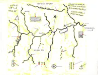
The Imlay map has been altered when you search online, 'Reputed Silver Mines' has been removed, here is a copy of it I have. Just sharing for researchers who may be looking for it, also a portion of a Swift Journal version that describes the topography on and along Swift Camp Creek. Just by the way it is written alone, I don't believe this to be authentic...but a rewrite by someone in much more recent times. The monument rocks (the size of small homes) are easy to find on Swift Camp Creek at the junction of Dog Fork by hiking Swift Camp Creek trail...a beautiful hike.
...We reached the Big Sandy River after much hardship, but without mishap.
Munday knew the trails and the habits of the Indians so well that we were able to avoid them. From there we traveled west through a hilly country, following the creek bottoms until we came to a rocky country that looked like the end of the world.
A turbulent river was before us, and following its windings from the heights we came to the mouth of a large creek. Our path fell rapidly to the creek, which has small branches running through deep ravines having great cliffs rising on either side. On the opposite side of the creek from where we were the land rose up to a cliff that stood far back from the creek, and this cliff has a great hole in its side near the top. We called that the "lighthouse" we could see clear through it, and see the sky beyond.
Munday did not know where we were, but after following the creek on a southwest course, he reconized the hills on the opposite side, and said that if we were over there he knew how to reach the Indian trace, which was some miles below, and having reached the trace he would know how to go to the mine. He said that we had to go through a laurel thicket and then down a flight of steps that the Indians had cut in the side of the cliff at the top of it; and that across the creek from the foot of the cliff at that point and in the cliffs of the other side was the mine.
We crossed the creek by a natural rock bridge, and Munday led us to a place that the Indians used for a camping ground, and for games when on thier hunting trips. This was not the time of year for them, and we did not see any of them. We camped there, and a creek flowed by our camp. When we went out with Munday again he could not find the laurel thicket, and we came again to the rock bridge, and from there we went down a rocky branch, and there were vines closing the entrance mouth of the branch.
We camped in this branch and kept our horses there. We could leave them there grazing while exploring the country, because the cliffs made an enclosure except for the entrance, which was closed by grapevines. Munday could not find the cliff where the mine was, but one day he called out to us and said: "here is the laurel thicket, i know the way now" Through this thicket we reached the steps in the cliff. From there i can point to the mine." It was hard to get through the thicket. We could not take our horses, and we stumbled many times and had to fight and cut our way. We got to the Indian steps which are cut in the side of the cliff.
You can stand on top of the rock there and look across the creek, and to your left the creek cuts through the cliff, and the cliffs in front are shapes of a half-moon.
Just above the creek, on the other side, there is a ledge, and higher up another ledge, and up near the top of the cliff a third ledge, and between the second and third ledges Munday said was the opening to the mine. Now we crossed the creek and climbed up to the second and third ledge, and then we went west a couple of hundred yards and found the mine. There was a big rock that looked like a buffalo sitting down, resting on the slope within a few hundred feet of the opening to the mine. We cut our names on that rock, Swift, Munday, Jefferson and others. We got ore and we smelted in a rock house which is in the second ledge. This rock-house faces the sunrise, and looking out there is a branch of a creek that comes in from the southwest and just below the mouth of that branch are three monument rocks, one large one, and two small ones. They are layers of rock and they taper to a point at the top...
Hope this helps someone. The 'Reputed Silver Mines' are located East of the headwaters of the KY River and West of the Big Sandy on the Imlay map below. Why it has been altered online is still in question. Save this copy for your own records.


 valley which mecca indians, etc.. talks about 20 miles, do you think maybe he meant 2 miles or 4 miles.. etc...