
gjb
Sr. Member
- #1
Thread Owner
It really could be that simple. The aim is straightforward: provide instructions to locate the deposit, but make them so cryptic that nobody without inside knowledge can break them. However, this would depend on not leaving information on the island that would enable someone to work it out (as was done)!
How does it work? The Rocks are positioned geometrically from the Money Pit and their locations can thus be determined to eight decimal places (to the nearest millimetre) using either early 17th century logarithmic tables or a modern calculator.
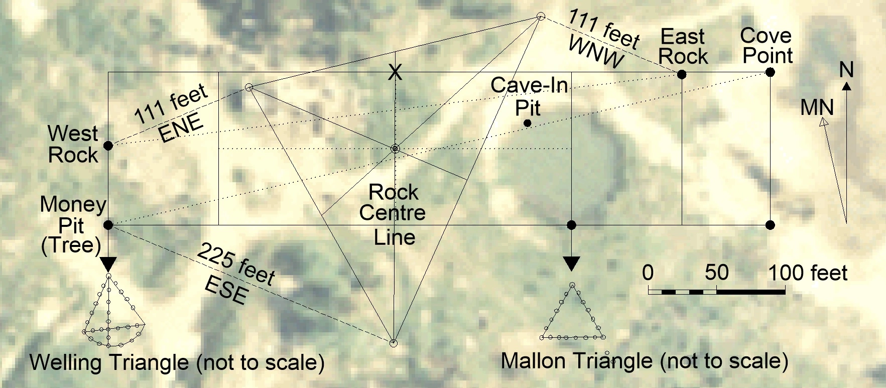
As in the image, the aim is to communicate the location of the ‘X’ at top centre of the inner rectangle using the procedure noted. It’s therefore required to specify three offsets, these being in whole numbers of the same unit, bearing at one of the 16 points of the compass from the Rocks and the Tree, thereby forming a triangle. Then, find the centre of the triangle and take a further offset from that point in any appropriate unit.
It’s not as difficult as you might think, particularly with CAD software, but neither does it take at all long using a sheet of paper and logarithmic tables. Note that there is a formula for locating the centre of a triangle by medians.
As shown in the image, the plan is to form a triangle with its centre at the middle of the rectangle marked and then go due north to the ‘X’. The process begins by trial and error, the method shown getting to within an inch of the rectangle's centre horizontally, and then reaching the ‘X’ by using the following instructions:
From the East Rock 111 feet WNW (292.5̊). From the West Rock 111 feet ENE (67.5̊).
From the Tree 225 feet ESE (112.5̊).
From the centre of the triangle 56 feet N (0̊).
However, anybody could work this out, so it’s sensible to make it cryptic. Thus, I convert the units on the first two lines into yards, but not mention this, and combine and reverse the lines. Since the final offset of 56 feet is (7 feet × 8) I’ll make it less obvious, that is, express the distance as 7 feet + 7 feet + (6 × 7 feet), that is, a + b + ac. I avoid specifying a bearing on the last line by informing you that the offset is always in the direction of the Rock Centre Line or, if already on that line, the mid-point of the line between the rocks unless specified otherwise, but always on true bearings (that is, N, S, E or W.) Then I have:
37 ENE and by 37 WNW on Rock
75 ESE Tree
7 feet by 7 feet by 6.
So, now you know how the map instructions work, though there’s still a bit of work to do. As a reminder, the instructions are as follows, the second instruction set being the most straightforward:
1. 18 NE and by 71 W on Rock; 25 ENE 18 SW Tree; 7 feet by 7 feet by 8.
2. 50 feet N and by 8 feet S on Rock; 20 feet NE Tree; 5 feet by 4 feet by 5.
3. 18 W and by 7 E on Rock; 30 SW, 14 N Tree; 7 By 8 By 4.
4. 515 SE and by 50 N; 36 NE, 36 NE Rocks; 3 feet by 3 feet by Four.
5. 360 yards V.R. North 3 stumps 55 feet: from centre of triangle betwixt Rocks; 20 feet E.
All you need to do is to accept that the instructions aren’t fake and actually apply to Oak Island, no matter what so-called or self-styled ‘experts’ say, and then identify where they lead to on the image above perhaps by using the scale bar and a protractor. Together, they actually form a pattern taking the form of a 'W'.
However, it’s far easier and more accurate if I tell you that the West Rock is 57.83 feet due north of the Money Pit (Tree) and the East Rock is 418 feet due east of the Tree and then 109.24 feet due north (thereby making things easy to calculate). You can check this with the Roper Survey of 1937.
How does it work? The Rocks are positioned geometrically from the Money Pit and their locations can thus be determined to eight decimal places (to the nearest millimetre) using either early 17th century logarithmic tables or a modern calculator.
As in the image, the aim is to communicate the location of the ‘X’ at top centre of the inner rectangle using the procedure noted. It’s therefore required to specify three offsets, these being in whole numbers of the same unit, bearing at one of the 16 points of the compass from the Rocks and the Tree, thereby forming a triangle. Then, find the centre of the triangle and take a further offset from that point in any appropriate unit.
It’s not as difficult as you might think, particularly with CAD software, but neither does it take at all long using a sheet of paper and logarithmic tables. Note that there is a formula for locating the centre of a triangle by medians.
As shown in the image, the plan is to form a triangle with its centre at the middle of the rectangle marked and then go due north to the ‘X’. The process begins by trial and error, the method shown getting to within an inch of the rectangle's centre horizontally, and then reaching the ‘X’ by using the following instructions:
From the East Rock 111 feet WNW (292.5̊). From the West Rock 111 feet ENE (67.5̊).
From the Tree 225 feet ESE (112.5̊).
From the centre of the triangle 56 feet N (0̊).
However, anybody could work this out, so it’s sensible to make it cryptic. Thus, I convert the units on the first two lines into yards, but not mention this, and combine and reverse the lines. Since the final offset of 56 feet is (7 feet × 8) I’ll make it less obvious, that is, express the distance as 7 feet + 7 feet + (6 × 7 feet), that is, a + b + ac. I avoid specifying a bearing on the last line by informing you that the offset is always in the direction of the Rock Centre Line or, if already on that line, the mid-point of the line between the rocks unless specified otherwise, but always on true bearings (that is, N, S, E or W.) Then I have:
37 ENE and by 37 WNW on Rock
75 ESE Tree
7 feet by 7 feet by 6.
So, now you know how the map instructions work, though there’s still a bit of work to do. As a reminder, the instructions are as follows, the second instruction set being the most straightforward:
1. 18 NE and by 71 W on Rock; 25 ENE 18 SW Tree; 7 feet by 7 feet by 8.
2. 50 feet N and by 8 feet S on Rock; 20 feet NE Tree; 5 feet by 4 feet by 5.
3. 18 W and by 7 E on Rock; 30 SW, 14 N Tree; 7 By 8 By 4.
4. 515 SE and by 50 N; 36 NE, 36 NE Rocks; 3 feet by 3 feet by Four.
5. 360 yards V.R. North 3 stumps 55 feet: from centre of triangle betwixt Rocks; 20 feet E.
All you need to do is to accept that the instructions aren’t fake and actually apply to Oak Island, no matter what so-called or self-styled ‘experts’ say, and then identify where they lead to on the image above perhaps by using the scale bar and a protractor. Together, they actually form a pattern taking the form of a 'W'.
However, it’s far easier and more accurate if I tell you that the West Rock is 57.83 feet due north of the Money Pit (Tree) and the East Rock is 418 feet due east of the Tree and then 109.24 feet due north (thereby making things easy to calculate). You can check this with the Roper Survey of 1937.
Last edited:
















