What's new

Take Offsets from the East Rock, West Rock and Tree, and then from Centre of Triangle

The question is am asking myself is.. would the captain what to use complex math, hide boulder locations or both.

The simplest solution is two boulders (east rock west rock). Using only two boulders would be less conspicuous yet use them as corners to derive a rectangle using NSEW bearings. The center of the rectangle or one the sides becomes "X". This seems easy enough to remember using the triangle sailing ship to mark the island.

The only question would be...does this simple solution allow those who helped bury the treasure keep from returning on their own and making off with it.

This could be why a complex mathematics is needed but if the calculations place "X" at the center of one of sides, the mathematics would be useless
Is the math truly complex? Is it actually advanced for the age? Would it not be essentially basic in an elite education of the time? Euclid must have been drummed into upper-class schoolboys then. They'd only have to know the basics of trigonometry on top of that. It wouldn't even have been necessary for them to be able to solve triangles, as there's a straightforward formula for finding the centre.

I've never thought of the math required as being complex, though I fully appreciate that many today wouldn't find it easy or wouldn't want to go there. This is potentially why so many people dismiss the idea. However, is tenth grade math truly complex rather than just difficult for some? And wouldn't the same have applied a few hundred years ago?
 
Is the math truly complex? Is it actually advanced for the age? Would it not be essentially basic in an elite education of the time? Euclid must have been drummed into upper-class schoolboys then. They'd only have to know the basics of trigonometry on top of that. It wouldn't even have been necessary for them to be able to solve triangles, as there's a straightforward formula for finding the centre.

I've never thought of the math required as being complex, though I fully appreciate that many today wouldn't find it easy or wouldn't want to go there. This is potentially why so many people dismiss the idea. However, is tenth grade math truly complex rather than just difficult for some? And wouldn't the same have applied a few hundred years ago?
This is not my area of expertise but I would suspect a drawing compass, dividers and a straight edge would have been available to identify a dig location based on two marked rocks.

The distances from the stones to intersecting arcs would be kept secret or even disguised mathematically

I guess my question is...what would a reasonable method to hide treasure you plan to dig up in a couple of years when you return from the south seas?
Is something more complex then drafting tools really required?
 
Last edited:
It really could be that simple. The aim is straightforward: provide instructions to locate the deposit, but make them so cryptic that nobody without inside knowledge can break them. However, this would depend on not leaving information on the island that would enable someone to work it out (as was done)!

How does it work? The Rocks are positioned geometrically from the Money Pit and their locations can thus be determined to eight decimal places (to the nearest millimetre) using either early 17th century logarithmic tables or a modern calculator.
View attachment 2216191
As in the image, the aim is to communicate the location of the ‘X’ at top centre of the inner rectangle using the procedure noted. It’s therefore required to specify three offsets, these being in whole numbers of the same unit, bearing at one of the 16 points of the compass from the Rocks and the Tree, thereby forming a triangle. Then, find the centre of the triangle and take a further offset from that point in any appropriate unit.

It’s not as difficult as you might think, particularly with CAD software, but neither does it take at all long using a sheet of paper and logarithmic tables. Note that there is a formula for locating the centre of a triangle by medians.

As shown in the image, the plan is to form a triangle with its centre at the middle of the rectangle marked and then go due north to the ‘X’. The process begins by trial and error, the method shown getting to within an inch of the rectangle's centre horizontally, and then reaching the ‘X’ by using the following instructions:

From the East Rock 111 feet WNW (292.5̊). From the West Rock 111 feet ENE (67.5̊).
From the Tree 225 feet ESE (112.5̊).
From the centre of the triangle 56 feet N (0̊).

However, anybody could work this out, so it’s sensible to make it cryptic. Thus, I convert the units on the first two lines into yards, but not mention this, and combine and reverse the lines. Since the final offset of 56 feet is (7 feet × 8) I’ll make it less obvious, that is, express the distance as 7 feet + 7 feet + (6 × 7 feet), that is, a + b + ac. I avoid specifying a bearing on the last line by informing you that the offset is always in the direction of the Rock Centre Line or, if already on that line, the mid-point of the line between the rocks unless specified otherwise, but always on true bearings (that is, N, S, E or W.) Then I have:

37 ENE and by 37 WNW on Rock
75 ESE Tree
7 feet by 7 feet by 6.

So, now you know how the map instructions work, though there’s still a bit of work to do. As a reminder, the instructions are as follows, the second instruction set being the most straightforward:

1. 18 NE and by 71 W on Rock; 25 ENE 18 SW Tree; 7 feet by 7 feet by 8.
2. 50 feet N and by 8 feet S on Rock; 20 feet NE Tree; 5 feet by 4 feet by 5.
3. 18 W and by 7 E on Rock; 30 SW, 14 N Tree; 7 By 8 By 4.
4. 515 SE and by 50 N; 36 NE, 36 NE Rocks; 3 feet by 3 feet by Four.
5. 360 yards V.R. North 3 stumps 55 feet: from centre of triangle betwixt Rocks; 20 feet E.

All you need to do is to accept that the instructions aren’t fake and actually apply to Oak Island, no matter what so-called or self-styled ‘experts’ say, and then identify where they lead to on the image above perhaps by using the scale bar and a protractor. Together, they actually form a pattern taking the form of a 'W'.

However, it’s far easier and more accurate if I tell you that the West Rock is 57.83 feet due north of the Money Pit (Tree) and the East Rock is 418 feet due east of the Tree and then 109.24 feet due north (thereby making things easy to calculate). You can check this with the Roper Survey of 1937.
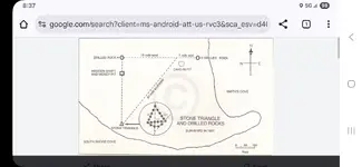
According to this drawing, the 2 drilled rocks are in line with each other and you’re drawing shows the East Rock further north and not in line.
 

Attachments

  • Screenshot_20250713_203752_Chrome.webp
    Screenshot_20250713_203752_Chrome.webp
    64.9 KB · Views: 71
According to this drawing, the 2 drilled rocks are in line with each other and you’re drawing shows the East Rock further north and not in line.
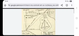
Here's one that looks like diagram. How do you know which one is correct?
 

Attachments

  • Screenshot_20250713_204459_Chrome.webp
    Screenshot_20250713_204459_Chrome.webp
    100.8 KB · Views: 63
Here's one that looks like diagram. How do you know which one is correct?
This diagram is essentially correct, being based on a survey by Charles Roper in 1937. He determined that the Rocks were 421.5 feet apart and that the East Rock bore at seven degrees north of due east from the West Rock. The Roper Survey also established the approximate location of the Welling Triangle (inset on your diagram) which was found to lie due south of the Money Pit area.

You will perhaps appreciate that the angle of tilt of the Welling Triangle is related to 30 degrees, that is, it is one-fifth of the tangent . This is a clue to the angle of magnetic variation which is two-fifths the tangent of 30 degrees (effectively, 13 degrees). On my diagram, this is the bearing of the Cove Point from the Money Pit (thus bearing magnetic east) and is the reason why equilateral triangles then appear in the area between.

The Roper Survey is key in any attempt to reconstruct the original survey by which the two drilled rocks and the two triangles were positioned. The Welling Triangle is also an essential feature of this. In fact, without the Welling and Mallon Triangles I doubt that a reconstruction would have been possible.

The image below shows the main points of the reconstruction and the predominance of equilateral triangles (60 and 30 degrees). The instruction sets target the points labelled A, C, D, E and F. Point G is the Cave-In Pit where somebody dug a hole about 18 feet deep and 8 feet in diameter and then filled it in.
Facebook Rocks.webp

I trust this provides a better indication of how and why the Rocks and Triangles are where they are. The line between the Pit and the Cove Point being 495 feet (30 rods) at 13 degrees the locations of all the points can be calculated (to eight decimal places if required).

This reconstruction matches the findings of the Roper Survey of 1937, placing the Rocks 421.2 feet apart at an angle of 7 degrees 00' 41". The location of the Welling Triangle is also consistent with the findings of the survey.
 
This diagram is essentially correct, being based on a survey by Charles Roper in 1937. He determined that the Rocks were 421.5 feet apart and that the East Rock bore at seven degrees north of due east from the West Rock. The Roper Survey also established the approximate location of the Welling Triangle (inset on your diagram) which was found to lie due south of the Money Pit area.

You will perhaps appreciate that the angle of tilt of the Welling Triangle is related to 30 degrees, that is, it is one-fifth of the tangent . This is a clue to the angle of magnetic variation which is two-fifths the tangent of 30 degrees (effectively, 13 degrees). On my diagram, this is the bearing of the Cove Point from the Money Pit (thus bearing magnetic east) and is the reason why equilateral triangles then appear in the area between.

The Roper Survey is key in any attempt to reconstruct the original survey by which the two drilled rocks and the two triangles were positioned. The Welling Triangle is also an essential feature of this. In fact, without the Welling and Mallon Triangles I doubt that a reconstruction would have been possible.

The image below shows the main points of the reconstruction and the predominance of equilateral triangles (60 and 30 degrees). The instruction sets target the points labelled A, C, D, E and F. Point G is the Cave-In Pit where somebody dug a hole about 18 feet deep and 8 feet in diameter and then filled it in.
View attachment 2216712
I trust this provides a better indication of how and why the Rocks and Triangles are where they are. The line between the Pit and the Cove Point being 495 feet (30 rods) at 13 degrees the locations of all the points can be calculated (to eight decimal places if required).

This reconstruction matches the findings of the Roper Survey of 1937, placing the Rocks 421.2 feet apart at an angle of 7 degrees 00' 41". The location of the Welling Triangle is also consistent with the findings of the survey.
I've looked through your information several times and here is where we agree...
The use of drilled stones and triangle markers appear to be man-made.
However, the reason for the markers is still unknown.
If you assume they are to mark buried treasure, you then have to ask...
1. Is ALL the information to identify the treasure location encoded in the position of the stones and markers
2. Did the stones and markers serve their intended purpose and the treasure has already been recovered.

Thanks for posting because I learned new things from pursuing and understanding your theory.
 
I've looked through your information several times and here is where we agree...
The use of drilled stones and triangle markers appear to be man-made.
However, the reason for the markers is still unknown.
If you assume they are to mark buried treasure, you then have to ask...
1. Is ALL the information to identify the treasure location encoded in the position of the stones and markers
Astute! I reckon not. My initial thinking went something like this: There are seven points on the Rhombus Rectangle and we have instructions pointing to five. We’re missing maps or instructions for points B and G. Would this mean that there are seven deposits? Possibly not.

Consider that point G would seem to be at the location of the Cave-In Pit where it seems that somebody dug a hole just short of 20 feet deep. Might they have had a map with instructions pointing to this location and might they have assumed that this could have been the location of a treasure? Maybe, but if other people did the same at the other points then wouldn’t the pattern soon become obvious and thus defeat the object?

I feel that the pattern of points may simply exist to direct focus to a single point - possibly the centre of the Rhombus Rectangle. However, I don’t even think that this is the location of a planned deposit. There are other indicators, or potential clues, suggesting an extension of the geometry and I feel that this then identifies where a deposit may have been planned.
2. Did the stones and markers serve their intended purpose and the treasure has already been recovered.
I prefer referring to a planned deposit because I’m not sure there was one. Who knows? I would suspect that had there been one it would perhaps have been a fairly short term measure and therefore recovered. However, I do believe that the likely intended location is identifiable, so it might be possible to check this out. But I could be wrong!

My focus is to suggest that all this might suggest that a deposit was planned even if it did not take place. In this case, it would constitute potential evidence of a deposit on Oak Island when the existence of such evidence is vehemently denied by naysayers and skeptics.

Thus, why not test for the presence of the reconstruction on the island? Might this reveal markers not yet known or the significance of which is not yet appreciated?
Thanks for posting because I learned new things from pursuing and understanding your theory.
Thanks very much for your interest. It's disheartening that so many people won't even consider the hypothesis because they've decided that they know it's wrong without needing to hear what's being said and thereafter giving it due thought.

I'll be posting an outline of my views on how the instructions work in the next day or so.
 
Astute! I reckon not. My initial thinking went something like this: There are seven points on the Rhombus Rectangle and we have instructions pointing to five. We’re missing maps or instructions for points B and G. Would this mean that there are seven deposits? Possibly not.

Consider that point G would seem to be at the location of the Cave-In Pit where it seems that somebody dug a hole just short of 20 feet deep. Might they have had a map with instructions pointing to this location and might they have assumed that this could have been the location of a treasure? Maybe, but if other people did the same at the other points then wouldn’t the pattern soon become obvious and thus defeat the object?

I feel that the pattern of points may simply exist to direct focus to a single point - possibly the centre of the Rhombus Rectangle. However, I don’t even think that this is the location of a planned deposit. There are other indicators, or potential clues, suggesting an extension of the geometry and I feel that this then identifies where a deposit may have been planned.

I prefer referring to a planned deposit because I’m not sure there was one. Who knows? I would suspect that had there been one it would perhaps have been a fairly short term measure and therefore recovered. However, I do believe that the likely intended location is identifiable, so it might be possible to check this out. But I could be wrong!

My focus is to suggest that all this might suggest that a deposit was planned even if it did not take place. In this case, it would constitute potential evidence of a deposit on Oak Island when the existence of such evidence is vehemently denied by naysayers and skeptics.

Thus, why not test for the presence of the reconstruction on the island? Might this reveal markers not yet known or the significance of which is not yet appreciated?

Thanks very much for your interest. It's disheartening that so many people won't even consider the hypothesis because they've decided that they know it's wrong without needing to hear what's being said and thereafter giving it due thought.

I'll be posting an outline of my views on how the instructions work in the next day or so.
There are some indicators that nolans cross is man made. Have you extended your lines to see if there is a connection?

Or maybe the Rhombus Rectangle contains a scaled nolans cross.
 
There are some indicators that nolans cross is man made. Have you extended your lines to see if there is a connection?

Or maybe the Rhombus Rectangle contains a scaled nolans cross.
Maybe it is a two part solution
1. Nolans cross provides the proportion
2. Scale nolans cross to the two drilled stones.
 
The proposed test of the hypothesis will either provide support for it or not.
What's the proposed test of the hypothesis?
 
It's disheartening that so many people won't even consider the hypothesis because they've decided that they know it's wrong without needing to hear what's being said and thereafter giving it due thought.
Theoretical physicist Wolfgang Pauli once described an untestable hypothesis based on speculation as "not even wrong." That is, it's pure guesswork with no evidence for or against, so there can be no real scientific discussion of its merits. And in science, we can never prove something to be correct, we can only prove it to be wrong.

That's why I ask how you propose to test your hypothesis. From where I'm sitting, it's not even wrong.
 
Maybe it is a two part solution
1. Nolans cross provides the proportion
2. Scale nolans cross to the two drilled stones.
Nolan’s cross is a fake built by Nolan in an attempt to steal the thunder from Dan Blankenship.
 
What's the proposed test of the hypothesis?
With respect, you may not be able to appreciate the significance of the test, and to discuss it, without first actually understanding the hypothesis to be tested. Might I suggest that this be addressed once this has been presented?
 
Maybe it is a two part solution
1. Nolans cross provides the proportion
2. Scale nolans cross to the two drilled stones.
I can see that you're really probing the possibilities here, and you appear to be following much of my own thinking. As can be seen above, some are prepared to declare that they know for a fact (somehow) that Nolan's Cross is fake. This could be so, but nobody knows for sure, so I'm with you that we shouldn't dismiss the possibility that it might be part of the original operation.

Should this be so then the Cross would likely relate to the eastern geometry being discussed here. The relationship as I perceive it is not easy to explain, so may I tentatively suggest that you might read my book The Oak Island Concealment: Seeing Beyond the Money Pit (by G.J. Bath) available through Amazon (USA and Europe). This is probably the best way to appreciate my entire thinking on the subject, including a potential link to Nolan's Cross.
 
Theoretical physicist Wolfgang Pauli once described an untestable hypothesis based on speculation as "not even wrong." That is, it's pure guesswork with no evidence for or against, so there can be no real scientific discussion of its merits. And in science, we can never prove something to be correct, we can only prove it to be wrong.

That's why I ask how you propose to test your hypothesis. From where I'm sitting, it's not even wrong.
I fail to understand how you can possibly know if a hypothesis is untestable if you don't know what it is or how it's suggested that it might be tested.

It's perfectly clear that you can't be at all objective about this and that you've made up your mind that whatever is being proposed has to be wrong without your even knowing what it is. Furthermore, you seem to have some really strange ideas about the scientific method and the conduct of inquiry.
 
I fail to understand how you can possibly know if a hypothesis is untestable if you don't know what it is or how it's suggested that it might be tested.
Ummm... yeah... that's why I ask how it might be tested.

It's perfectly clear that you can't be at all objective about this and that you've made up your mind that whatever is being proposed has to be wrong without your even knowing what it is. Furthermore, you seem to have some really strange ideas about the scientific method and the conduct of inquiry.
All I can do is judge by what I've seen so far. What I've seen is a geometric hypothesis that could have been done dozens, maybe hundreds, of ways that result in treasure locations all over the place. Why is your solution any more valid than all the other possibilities, and how would you test its validity? This is Science 101.
 
Ummm... yeah... that's why I ask how it might be tested.


All I can do is judge by what I've seen so far. What I've seen is a geometric hypothesis that could have been done dozens, maybe hundreds, of ways that result in treasure locations all over the place. Why is your solution any more valid than all the other possibilities, and how would you test its validity? This is Science 101.
Then why are you judging the matter solely on what you've seen so far? Why didn't you wait until you'd seen the argument through to the end before commenting? You've simply demonstrated that your totally biased. You've already made up your mind about this. It won't matter what I say, you're just going to say it's wrong without having seen in tested and, what's more, deciding that it can't be tested. That's outright prejudgement. And that's also Science 101.
 
As I see it , I can't get there from here! :laughing7:
As you haven’t been told enough to know where ‘here’ is and haven’t yet been told where ‘there’ is, it stands to reason that you can’t see how to get from ‘here’ to ‘there’.

This aside, you’re someone else who’s signalling that you’ve decided you know what the answer is or isn’t and have no intention of listening to what others have to say, particularly if they don’t agree with you.

This is a failure to have an open mind, which could well be the reason why little progress has been made in making inroads into the mystery over the last 230 years.
 
Why didn't you wait until you'd seen the argument through to the end before commenting?
If there's more, then post it. Or do I have to buy your book?
 

Users who are viewing this thread

Back
Top Bottom