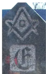
Things For Further Research

OP
OP
M

mdog

Bronze Member
Mar 22, 2011
2,366
4,419
I wonder if they considered the O.A.K. monuments and other man made statues with their symbolism as a permanent clue in this area? The rivers and streams here were the only permanent markers to identify an area besides the bluffs. There are no rocks to speak of and at that time there were very few trees.....it was a sea of grass.
L.C.

That tip that sdcfia gave us about the survey markers could be real helpful in that sea of grass.

You mentioned in one of your posts something about a big triangle in the middle of the country. Can you give us any information about that triangle. Maybe something like the size of the triangle or what kind of markers you have at the points?
 

dtpost

Full Member
Jan 3, 2011
172
52
Florida, Virginia
Detector(s) used
White's MXT,BH
Primary Interest:
All Treasure Hunting
The second picture on the first post shows a freemason shape on the lower island, the swamp reminds me of the freemason shape compass and square. I checked the depth of the compass crossing the square and it seems point on.
 

L.C. BAKER

Silver Member
Sep 9, 2012
3,805
4,643
Nebraska City, Nebraska
Primary Interest:
Other
That tip that sdcfia gave us about the survey markers could be real helpful in that sea of grass.

You mentioned in one of your posts something about a big triangle in the middle of the country. Can you give us any information about that triangle. Maybe something like the size of the triangle or what kind of markers you have at the points?


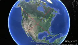
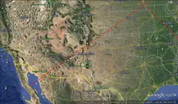
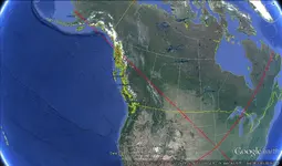
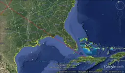
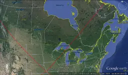
Think about every K.G.C. Treasure site you have heard of, and every place the K.G.C. was stationed and took over with force or planted a flag. There is a further explanation of the significance of this cross, but I don't want to talk about it here, sorry. I will show you the lines and where they cross the U.S.A. and some ocean and point out some areas hit by the lines in question. It is significant to the K.G.C. and the O.A.K. If you know of a site that is crossed by these lines, I would check it out! :thumbsup:
oak cross.jpg baja line.jpg alaska line.jpg cuba line.jpg line4.jpg Arbor Lodge.jpg

and at the center of it

morton marker.jpg
 

Last edited:
OP
OP
M

mdog

Bronze Member
Mar 22, 2011
2,366
4,419
OP
OP
M

mdog

Bronze Member
Mar 22, 2011
2,366
4,419
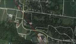
Think about every K.G.C. Treasure site you have heard of, and every place the K.G.C. was stationed and took over with force or planted a flag. There is a further explanation of the significance of this cross, but I don't want to talk about it here, sorry. I will show you the lines and where they cross the U.S.A. and some ocean and point out some areas hit by the lines in question. It is significant to the K.G.C. and the O.A.K. If you know of a site that is crossed by these lines, I would check it out! :thumbsup:
View attachment 1257540 View attachment 1257541 View attachment 1257542 View attachment 1257543 View attachment 1257544 View attachment 1257545

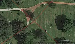
and at the center of it

View attachment 1257546


L.C., when running lines, it's a good idea to stock up on Tylenol and some rum and coke.....forget the coke. Oak Island seems to be a good place to start, as well as Victorio Peak and the Washington Monument. Start at theses places and run them through your spot and continue on to the opposite border of the U.S. When you start at Oak Island and go through your spot, you will pass through a treasure legend cluster in south central Colorado, Marble Mt., Culebra Peak, Blanca Peak and Spanish Peak. It also finishes up at tha SW corner of the United States which is important because a lot of the triangles I have found form compact clusters at five points on the U.S. border. The points on the clusters are found when you quarter the sides on a triangle and then start running lines from and to the quarter points. I've found that these clusters have been used to determine important landmarks and place names on the large triangles. The five spots on the border are at the tip of Texas, the tip of Florida, the SW Arizona border, the NW Washington border and the NE border of Maine.

In one of Scott Wolter's books, he writes about a group of ten Masons who wanted to buy the site where the Kensington Rune Stone was found. I think this happened back in the 1920s or 30s. They wanted to erect a huge obelisk monument, half the size of the Washington Monument obelisk. For some reason, the deal fell through. If you run a line from the Washington Monument through the site where the Kensington Stone was found, you end up on the NW corner of Washington State. I'm sure it's just a coincidence. :dontknow:
 

OP
OP
M

mdog

Bronze Member
Mar 22, 2011
2,366
4,419
Why are triangles so common at some sites? Here's a link that might explain why and also show a Masonic link to the right and equilateral triangles.

Masonic Dictionary | TRIANGLE | www.masonicdictionary.com

I think the place of importance on a right triangle is probably at the right angle area. You might find a cache site of several hundred yards on the perimeter with a dig site, also shaped like a right triangle. Both of these triangles could be at the right angle of an even bigger right angle with a perimeter of twenty miles or more. Where I'm at, there are three triangles setup like this. The south point of the large triangle is very important and an 80 mile equilateral triangle was used to confirm that. There were three cemeteries used to place the points on the triangle and another cemetery was used to direct to the first of those three. It gives me a headache just thinking about it. :BangHead: This stuff is very complicated and I agree with Steve, unless you have the code, you're not going to find anything. I have to admit, if you accept the idea that you are not going to find anything, it's a great hobby. You get to spend a lot of time outside, looking for clues, and you will learn a lot from your research.
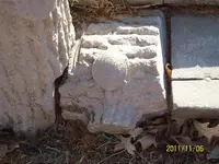
 

L.C. BAKER

Silver Member
Sep 9, 2012
3,805
4,643
Nebraska City, Nebraska
Primary Interest:
Other
Why are triangles so common at some sites? Here's a link that might explain why and also show a Masonic link to the right and equilateral triangles.

Masonic Dictionary | TRIANGLE | www.masonicdictionary.com

I think the place of importance on a right triangle is probably at the right angle area. You might find a cache site of several hundred yards on the perimeter with a dig site, also shaped like a right triangle. Both of these triangles could be at the right angle of an even bigger right angle with a perimeter of twenty miles or more. Where I'm at, there are three triangles setup like this. The south point of the large triangle is very important and an 80 mile equilateral triangle was used to confirm that. There were three cemeteries used to place the points on the triangle and another cemetery was used to direct to the first of those three. It gives me a headache just thinking about it. :BangHead: This stuff is very complicated and I agree with Steve, unless you have the code, you're not going to find anything. I have to admit, if you accept the idea that you are not going to find anything, it's a great hobby. You get to spend a lot of time outside, looking for clues, and you will learn a lot from your research.

In our case the second point of the triangle is a fixed compass point and it would be the right angle corner. The third corner is just a miners mark, but you had to decode a cipher to find the distance, the heading came from the compass point. That ciphered cross was on a line about 45 feet away from the compass point in the right angle (@2) another coded cross was recovered. As far as running the lines I agree with you, it would take a lot of time to find what you were directed to without a popper distance to travel from a starting point, or a Tobias. On the first piece found there was a word written down the face of the Cross it was SAGE It had two meanings, It was the nickname of the man that wore it around his neck and the word SAGE had a Spanish meaning for each letter. That turtles tail points dead east too! It used to be about one mile from town, and now it is surrounded by residential housing. There are 6 sites in all and you had to find the last site to locate the second point of the triangle that I described. Along the way we have also located the live gunsight tree that I posted which was next to a prominent Freemason's grave high on top of a hill and it points an entirely different direction than the one you are sent on to find the next place. I have no idea where it leads if it does lead. We have also identified another crescent moon that is used to identify (eye catcher)another heading from the second compass point that I described above, also in a different direction that sends you to a spot located in what was Indian territory.Until this happened....
https://en.wikipedia.org/wiki/Dawes_Act


new jobs 082.JPG
 

L.C. BAKER

Silver Member
Sep 9, 2012
3,805
4,643
Nebraska City, Nebraska
Primary Interest:
Other
"That tip that sdcfia gave us about the survey markers could be real helpful in that sea of grass"- mdog

It is a very good tip to locate an old area that is not there now. I have not looked for the markers in the field it will be something that I have to check out this coming season. We have some unidentified symbols on several pieces that do not decode with the key and we have always thought they could be referring to surveyed areas. There is a ghost town we have located that had over 800 people there and a post office and river port in 1857 that we will be going back to this summer and the cemetery for the town has been lost over the years. I can find people that I know were important there on the internet and they all have death unknown. There was no church there until 1861 and it was a hotbed of saloons brothels and docks ran by crooks and degenerates of every sort. The town disappeared by the end of the Civil War and can only be identified by the remnants of the docks on the River.

L.C.
 

OP
OP
M

mdog

Bronze Member
Mar 22, 2011
2,366
4,419
In our case the second point of the triangle is a fixed compass point and it would be the right angle corner. The third corner is just a miners mark, but you had to decode a cipher to find the distance, the heading came from the compass point. That ciphered cross was on a line about 45 feet away from the compass point in the right angle (@2) another coded cross was recovered. As far as running the lines I agree with you, it would take a lot of time to find what you were directed to without a popper distance to travel from a starting point, or a Tobias. On the first piece found there was a word written down the face of the Cross it was SAGE It had two meanings, It was the nickname of the man that wore it around his neck and the word SAGE had a Spanish meaning for each letter. That turtles tail points dead east too! It used to be about one mile from town, and now it is surrounded by residential housing. There are 6 sites in all and you had to find the last site to locate the second point of the triangle that I described. Along the way we have also located the live gunsight tree that I posted which was next to a prominent Freemason's grave high on top of a hill and it points an entirely different direction than the one you are sent on to find the next place. I have no idea where it leads if it does lead. We have also identified another crescent moon that is used to identify (eye catcher)another heading from the second compass point that I described above, also in a different direction that sends you to a spot located in what was Indian territory.Until this happened....
https://en.wikipedia.org/wiki/Dawes_Act


View attachment 1257894

That was a good post, L.C. and thanks for sharing the information.

I know you have to protect your site, but I was wondering if you can let us know the perimeter of your triangle. Also, was the turtle, with the tail pointing east, on the point of the triangle with the smallest degree of angle and maybe the northern point? One of the triangles I've studied has the northern point in a cemetery and a line of related monuments with an important date led east where I found another cemetery four miles away which also had clues.
 

OP
OP
M

mdog

Bronze Member
Mar 22, 2011
2,366
4,419
Rebel-KGC has offered a tip about the use of the Moon signs. Waxing Moon-getting close to "site of interest". Full Moon is where you want to look. Waning Moon means you've already passed it...go back.

I spent a long time trying to figure out a symbol that I thought was a capital D but the symbol was used the way Rebel described. I found the D about halfway through the trail and another D about 100 feet from a big hole that had been dug out and left open. I always thought the symbols were just two D's but the easiest approach for the second D was to go up a slight incline and from that angle you had a reverse D. There was a small pie shaped pointer, about 9 inches from the vertical line of the reverse D, that pointed to a notch on the vertical line that gave the direction to go to the open hole. I wonder if the reverse D (waning Moon) could also be used to confirm a decoy site, if there's a pointer associated with it. Well, actually, until somebody shows me a huge treasure that was found following symbols, it's just my opinion that they're all decoy sites. Anyway, The reverse D sign was a lot bigger than the capital D so, if I back tracked to the small D and moved on a couple hundred yards further, There was a perfect carving of an O (full Moon) next to a perfect carved heart. Tylenol anybody?
 

Rebel - KGC

Gold Member
Jun 15, 2007
21,680
14,740
Rebel-KGC has offered a tip about the use of the Moon signs. Waxing Moon-getting close to "site of interest". Full Moon is where you want to look. Waning Moon means you've already passed it...go back.

I spent a long time trying to figure out a symbol that I thought was a capital D but the symbol was used the way Rebel described. I found the D about halfway through the trail and another D about 100 feet from a big hole that had been dug out and left open. I always thought the symbols were just two D's but the easiest approach for the second D was to go up a slight incline and from that angle you had a reverse D. There was a small pie shaped pointer, about 9 inches from the vertical line of the reverse D, that pointed to a notch on the vertical line that gave the direction to go to the open hole. I wonder if the reverse D (waning Moon) could also be used to confirm a decoy site, if there's a pointer associated with it. Well, actually, until somebody shows me a huge treasure that was found following symbols, it's just my opinion that they're all decoy sites. Anyway, The reverse D sign was a lot bigger than the capital D so, if I back tracked to the small D and moved on a couple hundred yards further, There was a perfect carving of an O (full Moon) next to a perfect carved heart. Tylenol anybody?
YEP! That's what you want...
 

OP
OP
M

mdog

Bronze Member
Mar 22, 2011
2,366
4,419
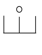
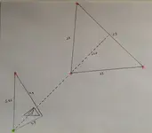
Here is a sketch of a large area that shows how cemeteries were used to confirm? a site of interest. The sketch is not even close to scale, as you can easily see. The pink spots are cemeteries and the green spot is a pond, shaped like a heart at the base of a large hill. There is a treasure legend associated with this hill but the legend is not well known.

cem t.jpg

The numbers are miles and the dotted line starts at the center of the NE base line and continues through the cemetery at the point of the large triangle and goes on to the heart pond. Steve's book was a real help in finding this stuff. The two cemeteries that form the west line of the big triangle have the same name and the one on the north consists of one grave. I didn't realize that the center point of the big triangles base line would go to the heart pond until I ran the line outside of the triangle. I was really surprised.
 

L.C. BAKER

Silver Member
Sep 9, 2012
3,805
4,643
Nebraska City, Nebraska
Primary Interest:
Other
We have had two full moons in this trail and the ciphered text that told us to come at the "HEWITCHING HOUR" which I believe was misspelled for a reason concerning the letter B or the number 13 or the full moon, but I am not 100% on it yet. At another site there is this O.A.K. coded cross which has the bird symbol and the full moon that Rebel had pointed out before in the word O.A.K. The bird is looking at it and his eye is also a full moon. I am sorry MDOG but I am not willing to give the distance of the triangle at this time because as you know it is very important to determining the final location from the triangles motherly corner. The third point of this K.G.C./ O.A.K. triangle was only found last year and we have not even thoroughly searched the area with the miners mark with the popper equipment yet. Speaking of which, there are no rocks to speak of here and there is a pile of dirt and stones with weeds growing out of it about 3 to 4 feet tall in the middle of nowhere. I am wondering if it didn't come from a hole they dug when they left a cache buried there at the third point.:dontknow: We also have to go the correct distance to search the point located from the triangles perimeter.(X 3 ?) We spent a lot of our time this year in a spot that was dictated by a copper strip left buried slightly above a lead cross and it was not coded and gave a heading and distance in plain text stamped into the copper. It is heavily wooded and it was also flooded part of the year also.:BangHead: I believe the copper strip was left by the O.A.K. in 1902 on top of an already existing K.G.C. lead piece with symbols that take you on another journey that was already laid out in the late 1860's-1880's by the K.G.C.. I think this copper piece was the O.A.K. adding cash from their kickback coffers to another K.G.C. cache trail that was already laid out and marked by their elders in the K.G.C. and their precise location of the copper piece above the older lead piece is some proof of it. The fact that it had to be done in 1902 brings the O.A.K. about 39 years past where they were reported to have dissolved and disbanded if you believe what you read in the history books.
I know we have some of the right places to look now, we just need the popper equipment to get the job done with 100% confidence that we have cleared an area!
bird.jpg midnight.jpg
 

L.C. BAKER

Silver Member
Sep 9, 2012
3,805
4,643
Nebraska City, Nebraska
Primary Interest:
Other
Rebel-KGC has offered a tip about the use of the Moon signs. Waxing Moon-getting close to "site of interest". Full Moon is where you want to look. Waning Moon means you've already passed it...go back.

I spent a long time trying to figure out a symbol that I thought was a capital D but the symbol was used the way Rebel described. I found the D about halfway through the trail and another D about 100 feet from a big hole that had been dug out and left open. I always thought the symbols were just two D's but the easiest approach for the second D was to go up a slight incline and from that angle you had a reverse D. There was a small pie shaped pointer, about 9 inches from the vertical line of the reverse D, that pointed to a notch on the vertical line that gave the direction to go to the open hole. I wonder if the reverse D (waning Moon) could also be used to confirm a decoy site, if there's a pointer associated with it. Well, actually, until somebody shows me a huge treasure that was found following symbols, it's just my opinion that they're all decoy sites. Anyway, The reverse D sign was a lot bigger than the capital D so, if I back tracked to the small D and moved on a couple hundred yards further, There was a perfect carving of an O (full Moon) next to a perfect carved heart. Tylenol anybody?

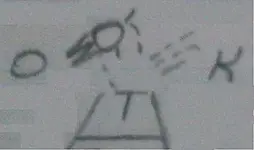
What do you think this moon is saying to us? Freemasons and K.G.C. crescent moon.jpg
 

Rebel - KGC

Gold Member
Jun 15, 2007
21,680
14,740
Rebel-KGC has offered a tip about the use of the Moon signs. Waxing Moon-getting close to "site of interest". Full Moon is where you want to look. Waning Moon means you've already passed it...go back.

I spent a long time trying to figure out a symbol that I thought was a capital D but the symbol was used the way Rebel described. I found the D about halfway through the trail and another D about 100 feet from a big hole that had been dug out and left open. I always thought the symbols were just two D's but the easiest approach for the second D was to go up a slight incline and from that angle you had a reverse D. There was a small pie shaped pointer, about 9 inches from the vertical line of the reverse D, that pointed to a notch on the vertical line that gave the direction to go to the open hole. I wonder if the reverse D (waning Moon) could also be used to confirm a decoy site, if there's a pointer associated with it. Well, actually, until somebody shows me a huge treasure that was found following symbols, it's just my opinion that they're all decoy sites. Anyway, The reverse D sign was a lot bigger than the capital D so, if I back tracked to the small D and moved on a couple hundred yards further, There was a perfect carving of an O (full Moon) next to a perfect carved heart. Tylenol anybody?
"D" & "Backward D" explained... CRESCENT MOON. "D"; "horns" of Moon are UP! "BACKWARD D"; "horns" of Moon are DOWN. FURTHER KGC "SIGNS" FULL MOON; dig in that area... HEART; got a BIG ONE! (Or was there, somebody else got it!). Back in the "old days" the KGC Signs would be "defaced" if Treasure(s) found... HBB knew this.
 

Rebel - KGC

Gold Member
Jun 15, 2007
21,680
14,740
We have had two full moons in this trail and the ciphered text that told us to come at the "HEWITCHING HOUR" which I believe was misspelled for a reason concerning the letter B or the number 13 or the full moon, but I am not 100% on it yet. At another site there is this O.A.K. coded cross which has the bird symbol and the full moon that Rebel had pointed out before in the word O.A.K. The bird is looking at it and his eye is also a full moon. I am sorry MDOG but I am not willing to give the distance of the triangle at this time because as you know it is very important to determining the final location from the triangles motherly corner. The third point of this K.G.C./ O.A.K. triangle was only found last year and we have not even thoroughly searched the area with the miners mark with the popper equipment yet. Speaking of which, there are no rocks to speak of here and there is a pile of dirt and stones with weeds growing out of it about 3 to 4 feet tall in the middle of nowhere. I am wondering if it didn't come from a hole they dug when they left a cache buried there at the third point.:dontknow: We also have to go the correct distance to search the point located from the triangles perimeter.(X 3 ?) We spent a lot of our time this year in a spot that was dictated by a copper strip left buried slightly above a lead cross and it was not coded and gave a heading and distance in plain text stamped into the copper. It is heavily wooded and it was also flooded part of the year also.:BangHead: I believe the copper strip was left by the O.A.K. in 1902 on top of an already existing K.G.C. lead piece with symbols that take you on another journey that was already laid out in the late 1860's-1880's by the K.G.C.. I think this copper piece was the O.A.K. adding cash from their kickback coffers to another K.G.C. cache trail that was already laid out and marked by their elders in the K.G.C. and their precise location of the copper piece above the older lead piece is some proof of it. The fact that it had to be done in 1902 brings the O.A.K. about 39 years past where they were reported to have dissolved and disbanded if you believe what you read in the history books.
I know we have some of the right places to look now, we just need the popper equipment to get the job done with 100% confidence that we have cleared an area!
View attachment 1258416 View attachment 1258419
KGC/OAK...? KGC is like the "Blue Lodge"; going "up" to Scottish Rite, is similar to OAK; NOTHING is "disbanded"
 

Rebel - KGC

Gold Member
Jun 15, 2007
21,680
14,740
"FACE"/"DE-FACED" explained... got a "pointer" Rock/Tree, etc...? Go in that direction. If "pointer" is broken off... "treasure(s)" ALREADY found. "Hoot Owl" Trees are MORE numerous on the East Coast; The "pointer" is THE NOSE (as in "sniffing out" Treasure, water, etc). If "pointer" (Nose) of tree is "sawed" off... TOO LATE! Trail Trees of Georgia are WONDERFUL! If "pointer" on Rock is broken off... TOO LATE! ANYWAY... HH! Good Luck!
 

sdcfia

Silver Member
Sep 28, 2014
3,670
8,913
Primary Interest:
Other
<cut>
Speaking of which, there are no rocks to speak of here and there is a pile of dirt and stones with weeds growing out of it about 3 to 4 feet tall in the middle of nowhere. I am wondering if it didn't come from a hole they dug when they left a cache buried there at the third point.:dontknow: <cut>

Empty holes can confuse because they represent several possibilities: 1) Someone was successful and previously dug up the loot, leaving an empty hole; 2) Someone thought the loot was there, dug a hole, found nothing, moved on; 3) The loot is actually buried next to the empty hole, under the adjacent pile of dirt; 4) The empty hole is meant to serve as a node on a mapped pattern; 5) The empty hole has nothing to do with the loot.
 

L.C. BAKER

Silver Member
Sep 9, 2012
3,805
4,643
Nebraska City, Nebraska
Primary Interest:
Other
KGC/OAK...? KGC is like the "Blue Lodge"; going "up" to Scottish Rite, is similar to OAK; NOTHING is "disbanded"

When I say K.G.C. / O.A.K. I mean to say that this trail was first put into place by the K.G.C. from 1849-1863 and then it was added to by the O.A.K. after 1863 at least until 1902. As far as my understanding of the lodge factor, I believe that the K.G.C. morphed into the O.A.K. through the hands of Jefferson Davis, Clement Vallandigham, Judah P. Benjamin and J.S. Morton along with a few others in 1863 following Vallandigham's banishment to the South, at which time he traveled to Richmond and met with the above named people. It has become a fact that the upper crust of the K.G.C. were all Freemasons, but that is to say....All FREEMASONS WERE NOT K.G.C.AND O.A.K., BUT ALL K.G.C. AND O.A.K. WERE FREEMASONS.

Just my two cents, L.C.:thumbsup:
 

L.C. BAKER

Silver Member
Sep 9, 2012
3,805
4,643
Nebraska City, Nebraska
Primary Interest:
Other
Empty holes can confuse because they represent several possibilities: 1) Someone was successful and previously dug up the loot, leaving an empty hole; 2) Someone thought the loot was there, dug a hole, found nothing, moved on; 3) The loot is actually buried next to the empty hole, under the adjacent pile of dirt; 4) The empty hole is meant to serve as a node on a mapped pattern; 5) The empty hole has nothing to do with the loot.

That is the thing sdcfia, there is no hole anywhere, just a pile of dirt and small stones with weeds in the middle of a wooded area with some pretty large trees around it..:dontknow:
 

Top Member Reactions

Users who are viewing this thread

Top