treasure cave by tortilla flat

A2coins

Gold Member
Dec 20, 2015
33,807
42,606
Ann Arbor
🏆 Honorable Mentions:
3
Detector(s) used
Equinox 800
Primary Interest:
All Treasure Hunting
I could have been shot in the gut I would have taken some of it with me and no way would I have not remembered clues of how to get back. I was told once about a rock that for some reason had a round hole chewed out of it and there were gold coins from the Military in bags inside the rock and the plug was carved out like a pumpkin with seems wierd that someone would waste all that time which must have taken for ever. I used to be on a Mobile Home set up crew an a older native American couple told me about this huge rock that was on thier property for generations. I was there for weeks putting this double wide in so we talked alot I think it was just another story like most of the rest of em. Its gotta be fun to look theres been people in the Superstitions who have lived in the Desert for many many years searching for treasure......Tommy
 

somehiker

Silver Member
May 1, 2007
4,365
6,426
Primary Interest:
All Treasure Hunting
Mitchell Waite, an author of a number of LDM books and articles who passed away in 2015, had written about and described the location of such a cave near Mormon Flat.
 

OP
OP
A

azdave35

Silver Member
Dec 19, 2008
3,606
8,104
Mitchell Waite, an author of a number of LDM books and articles who passed away in 2015, had written about and described the location of such a cave near Mormon Flat.
do you have the article wayne?...if so i'd appreciate seeing it:occasion14:
 

somehiker

Silver Member
May 1, 2007
4,365
6,426
Primary Interest:
All Treasure Hunting
do you have the article wayne?...if so i'd appreciate seeing it:occasion14:

The original article was posted at a link that's now a ticket seller website.
I'm pretty sure he had also shared it here though.....likely in one of the archives.
Been looking, but haven't found it yet. If I do, I'll pm you the link. I don't have much time right now though.

CryptoZooNews: Posts by Loren Coleman
 

OP
OP
A

azdave35

Silver Member
Dec 19, 2008
3,606
8,104
The original article was posted at a link that's now a ticket seller website.
I'm pretty sure he had also shared it here though.....likely in one of the archives.
Been looking, but haven't found it yet. If I do, I'll pm you the link. I don't have much time right now though.

CryptoZooNews: Posts by Loren Coleman
wayne...i looked at that website...just a bunch of dead bigfoot hunters:icon_scratch:
 

somehiker

Silver Member
May 1, 2007
4,365
6,426
Primary Interest:
All Treasure Hunting
wayne...i looked at that website...just a bunch of dead bigfoot hunters:icon_scratch:

Mitch had gravitated to searching for thr "Mogollon Monster" for a number of years, and had joined that group and website.
On the right-hand side of the page is a list of archived articles. Many articles by different authors, some about other topics.
I'm pretty sure Mitch had posted one about his prior searching for the LDM/Spanish Treasure, things he'd found, and how he had gone on to searching for the Arizona Bigfoot. It should be within those archives somewhere. I did come across a link to this.....


sdcfia

Silver Member
Sep 28, 2014
3,656
8,879
Primary Interest:
Other
Mitch had gravitated to searching for thr "Mogollon Monster" for a number of years, and had joined that group and website.
On the right-hand side of the page is a list of archived articles. Many articles by different authors, some about other topics.
I'm pretty sure Mitch had posted one about his prior searching for the LDM/Spanish Treasure, things he'd found, and how he had gone on to searching for the Arizona Bigfoot. It should be within those archives somewhere. I did come across a link to this.....


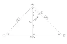
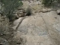
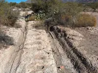
The wagon ruts in the video were interesting. While there are numerous examples of genuine ruts having been formed by heavily laden wagons constantly passing over soft rock outcroppings along terrain-confined routes (military wood haulers frequently), it's been alleged that "wagon ruts" at other certain locations were artificially created (ie carved) as disguised permanent markers to treasure caches or important mineral deposits. The fake ruts may located on too hard an outcropping in an unlikely spot where there were obvious easier wagon paths to follow. These ruts may occupy a position in a geometric pattern of other landmarks and manmade clues in the area.

Here's an example. A, B, C and D are all extremely significant sites (well-known natural landmarks and/or unique petroglyph locations), while E is a "wagon rut" location in quite an unlikely travel location, but in an important map location.

coincidences.jpg
IMG_0106.JPG
 

deducer

Bronze Member
Jan 7, 2014
2,281
4,360
Primary Interest:
Other
The wagon ruts in the video were interesting. While there are numerous examples of genuine ruts having been formed by heavily laden wagons constantly passing over soft rock outcroppings along terrain-confined routes (military wood haulers frequently), it's been alleged that "wagon ruts" at other certain locations were artificially created (ie carved) as disguised permanent markers to treasure caches or important mineral deposits. The fake ruts may located on too hard an outcropping in an unlikely spot where there were obvious easier wagon paths to follow. These ruts may occupy a position in a geometric pattern of other landmarks and manmade clues in the area.

Here's an example. A, B, C and D are all extremely significant sites (well-known natural landmarks and/or unique petroglyph locations), while E is a "wagon rut" location in quite an unlikely travel location, but in an important map location.

The ruts in that video are near the service road (down the bank) that goes to the Horse Mesa Dam. As this road starts from a point on the Apache trail that is closest to the Salt River at that point, my guess is that it had something to do with building the Apache trail itself- perhaps sourcing water from there?

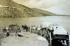
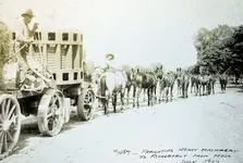
freighters-crossing-reservoir-on-govt-ferry.jpg moving-heavy-machinery-to-Roosevelt.jpg
 

OP
OP
A

azdave35

Silver Member
Dec 19, 2008
3,606
8,104
The ruts in that video are near the service road (down the bank) that goes to the Horse Mesa Dam. As this road starts from a point on the Apache trail that is closest to the Salt River at that point, my guess is that it had something to do with building the Apache trail itself- perhaps sourcing water from there?

View attachment 1837908 View attachment 1837909
could possibly be the wheel ruts by the arboretum also:icon_scratch:
 

somehiker

Silver Member
May 1, 2007
4,365
6,426
Primary Interest:
All Treasure Hunting
The ruts in that video are near the service road (down the bank) that goes to the Horse Mesa Dam. As this road starts from a point on the Apache trail that is closest to the Salt River at that point, my guess is that it had something to do with building the Apache trail itself- perhaps sourcing water from there?

View attachment 1837908 View attachment 1837909

My conclusion as well, since there is so little evidence of mineralization in the area.
But there is a water source in that direction.....worth even more out there.
 

somehiker

Silver Member
May 1, 2007
4,365
6,426
Primary Interest:
All Treasure Hunting
could possibly be the wheel ruts by the arboretum also:icon_scratch:

You mean the "Stoneman Grade" ore wagon ruts ?
Those are further apart and worn much deeper than the ones out near Fish Creek.
Bigger and much heavier wagons, pulled by mule teams.
 

Attachments

  • -Pinal 1885.jpg
    -Pinal 1885.jpg
    132.7 KB · Views: 105
Last edited:
OP
OP
A

azdave35

Silver Member
Dec 19, 2008
3,606
8,104
You mean the "Stoneman Grade" ore wagon ruts ?
Those are further apart and worn much deeper than the ones out near Fish Creek.
Bigger and much heavier wagons, pulled by mule teams.
wayne...the ones i'm talking about are between the silver king mine and the mill at pinal city at the north east end of picketpost mountain
Ore wagon tracks.jpg
 

deducer

Bronze Member
Jan 7, 2014
2,281
4,360
Primary Interest:
Other
wayne...the ones i'm talking about are between the silver king mine and the mill at pinal city at the north east end of picketpost mountain


Dave, not to speak for Wayne, but the pic he posted is from the mill at Pinal.
 

markmar

Silver Member
Oct 17, 2012
4,117
6,259
Primary Interest:
All Treasure Hunting
Mitch had gravitated to searching for thr "Mogollon Monster" for a number of years, and had joined that group and website.
On the right-hand side of the page is a list of archived articles. Many articles by different authors, some about other topics.
I'm pretty sure Mitch had posted one about his prior searching for the LDM/Spanish Treasure, things he'd found, and how he had gone on to searching for the Arizona Bigfoot. It should be within those archives somewhere. I did come across a link to this.....


IMHO, Dr. Thorne gold residual placer is the same to what Walz found and named as " placer " mine. Waltz found that outcrop and dug it out for a while, until became a narrow and shallow mine. What Dr.Thorne saw across the ravine as an ancient corral, was the two roofless two room house that Waltz has mentioned in his clues.
Now, if there are wagon ruts, only if Santa Claus landed there to brought presents to the miners, before Thorne and Waltz era.
 

Last edited:

markmar

Silver Member
Oct 17, 2012
4,117
6,259
Primary Interest:
All Treasure Hunting
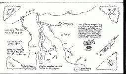
There are few caves in the Superstitions which possess gold bars within other treasures. Five of them possess only gold bars. These caves are depicted in Celeste Jones map as half turtles with their heads to be the spot of the caves. Two of them are described in stories publiced in Bob Ward's book " Ripples of Echoes ".
One story is about a guy by the name Roy Diamond which one rainy night , stumbled upon a cave with gold bars in the Superstitions. To relocate the spot, Roy marked the place with a pile of big rocks at the cave's entrance, but he wasn't able to find it again after intensive research.
Being aware of the caves region very well, after the Roy's description of the route he followed until he found the cave, I was able to understand which cave he has found. I can say the description was approx. 95% accurate, and like you will see in a GE image , the pile of rocks is still there.
When the Celeste Jones map ( found and given to her by Al Morrow ) was examined, because the strange words written in the map, many scientists said was a very difficult code which is still unbroken or was a very ancient language which is not yet discovered. But like I wrote in another thread when I explained this map, the words are nothing else but shapes on the ground which the author copied them on the map to ensure the accuracy of the region.
On the GE image with the pile of rocks ( yellow circle ), I put an overlay of the Celeste Jones map to see how the words and the shape of the turtle ( each has its own shape which fit its place ) are matching perfectly with the ground shapes chosen by the author.
Enjoy

attachment.php
 

somehiker

Silver Member
May 1, 2007
4,365
6,426
Primary Interest:
All Treasure Hunting
Celeste-Jones-14.gif

I've never spent much time on the Celeste Jones/Al Morrow map. A few years ago I asked Tom K. about it, having read the articles he had written about Al and Celeste shortly before the Rendezvous that year .

Tom Kollenborn Chronicles: A Visit to Needle Canyon

Tom Kollenborn Chronicles: Celeste Maria Arva Jones

He told me that Al had said he created the map as a joke, but Celeste thought it was real, so he gave it to her.

Maybe you should get together with BB. I think that's the same lingo he speaks when he's pretending to be an Aztec shaman.....eg: "i' n' n-aw' ...E" a P-aw' Sha ma chi '! ya ya hee' aw "

You both should be able to figure it all out.
 

somehiker

Silver Member
May 1, 2007
4,365
6,426
Primary Interest:
All Treasure Hunting
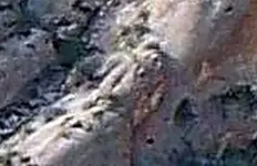
I've come across a few "turtles" while hiking in the Sups. This is probably the best....

100_0751  turtle.jpg
 

Top Member Reactions

Users who are viewing this thread

Latest Discussions

Top