What's new

Tributary Gold.

How deep is the Mojave River underground?
Do the Mojave River waters go down to magma levels of rock?
I'm sure there is more questions to ask that I have missed here.
No, from what i have read it dose not. It also says the Mojave River flows underground for about 100 miles during its course through the Desert & Mountains. @Assembler You should read about it it's very interesting.
 
Last edited:

I prefer the epic thriller, rock-nados
Each episode of this type of thriller always sings a signature tune going out for miles around that is at times even recorded in rock formations nearby.
 
No, from what i have read it dose not.
So, the water currently just completely flows to the ocean with a hot lifting plate nearby?
What happens when there is an earth shift or faultline opening up?
What happens with an earthquake?
Surely some water is diverted during any of these types of events.
 
So, the water currently just completely flows to the ocean with a hot lifting plate nearby?
What happens when there is an earth shift or faultline opening up?
What happens with an earthquake?
Surely some water is diverted during any of these types of events.
No it dose not flow to the Ocean. What it dose say is the river only appears above ground where bedrock forces the underground flow to the surface, such as in the San Bernardino Mountains and my claim ⛏️ @Assembler Just take a minuet and read the History Of the Mojave River its very interesting all your questions will be answered lol. And as one member says time for more ☕☕☕
 
Last edited:

No it dose not flow to the Ocean. What it dose say is the river only appears above ground where bedrock forces the underground flow to the surface, such as in the San Bernardino Mountains and my claim ⛏️
Correct like many underground rivers and creeks. The water course could have been changed by any nature's events underground over time especially over a 11-million-year period time frame. You may have an older river deposit where you are?
Let us know what you learn.
 
I just read the Geological modeling, depth to bedrock is very close to the surface in that area around my claim from one meter, to a few meters to tens of meters.
 
I will add this part of the Mojave River moves massive boulders that weigh upwards of 10 thousand pounds or more.
I don’t know where your claim is located, but in my area in Northern California, we have these forces of nature that move rock and gold. I fairly sure there were several methods of transport here. 1 The ancient blue gravels deposited by the river that flowed through California. You see remnants of it in Siskiyou, Shasta county, and south. The upheaval of mountains, the ocean erosion, the glacial transport..parking..melting..depositing..repeat again.

Evidence of all of this when you open your eyes.

There is and ancient ocean shoreline at the top of the Siskiyou Mountain Range at 6,800 feet above current sea level. Placer Gold concentrated along this shore line.

I didn’t read this entire thread, so maybe I’m missing something and am way off base. But there were ancient catastrophes that shaped many places in California.
 
There are documented glaciers as far south as Mount San Gorgonio. I’m not sure if that is anywhere near you.

This is an interesting video of an ancient river gravel mine. They tunneled 1200 feet into solid bedrock and hit ancient river gravels. It appears they knew exactly where they were going. Straight into the mountain 1200 feet to the underground deposit. Gravel on top of AND under bedrock. Crazy to think of how long that took.

You Tube video
 
Last edited:

There are documented glaciers as far south as Mount San Gorgonio. I’m not sure if that is anywhere near you.

This is an interesting video of an ancient river gravel mine. They tunneled 1200 feet into solid bedrock and hit ancient river gravels. It appears they knew exactly where they were going. Straight into the mountain 1200 feet to the underground deposit. Gravel on top of AND under bedrock. Crazy to think of how long that took.

You Tube video
Hi @Tesorodeoro I can see Mt San Gorgonio from my front yard its about 20ish miles from me. Every thing I read about my area you just said the same thing that's crazy lol. I am still learning about that area and now I will dive deeper into reading more about the Mojave River and the mountains that surround it. TY for that info.
 
Hi @Tesorodeoro I can see Mt San Gorgonio from my front yard its about 20ish miles from me. Every thing I read about my area you just said the same thing that's crazy lol. I am still learning about that area and now I will dive deeper into reading more about the Mojave River and the mountains that surround it. TY for that info.
That geologic history is part of what makes me interested in prospecting. Nothing is as simple as what most people assume is the result of a couple hundred years of natural erosion. There was stuff going on back when the dinosaurs were roaming and the earth’s mantle was still cooling.

I always thought the rivers cut their way through the mountains to their present location..um not typically. Those mountains were being shoved upward by tectonic plates, carrying ancient benches of gravel upwards, where gravity and nature could chip away at them, exposing gold deposited in the oxidized crust. “Volcanic activity”, you could call it that I suppose, but not in the traditional sense of large explosive volcanoes. More epithermal deposits fueled by shallow magma.
 
Last edited:
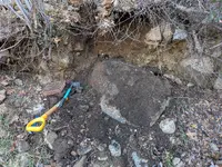
It is amazing the amount of massive boulders in my area and to find out most of them are non native and down right deadly as I found out digging around one that weighed about 6K that came crashing down just feet from me 😯
 

Attachments

  • PXL_20251205_181224141 (1).webp
    PXL_20251205_181224141 (1).webp
    4.2 MB · Views: 41
It is amazing the amount of massive boulders in my area and to find out most of them are non native and down right deadly as I found out digging around one that weighed about 6K that came crashing down just feet from me 😯
The non native is a strong clue here......Just saying a fisher / fault/ fracture opened up for some quick movement likely from below or even sideways.
 
There are documented glaciers as far south as Mount San Gorgonio. I’m not sure if that is anywhere near you.

This is an interesting video of an ancient river gravel mine. They tunneled 1200 feet into solid bedrock and hit ancient river gravels. It appears they knew exactly where they were going. Straight into the mountain 1200 feet to the underground deposit. Gravel on top of AND under bedrock. Crazy to think of how long that took.

You Tube video
Volcanic bedrock flow layer. Likely known about this flow layer near the surface.
 
That geologic history is part of what makes me interested in prospecting. Nothing is as simple as what most people assume is the result of a couple hundred years of natural erosion. There was stuff going on back when the dinosaurs were roaming and the earth’s mantle was still cooling.

I always thought the rivers cut their way through the mountains to their present location..um not typically. Those mountains were being shoved upward by tectonic plates, carrying ancient benches of gravel upwards, where gravity and nature could chip away at them, exposing gold deposited in the oxidized crust. “Volcanic activity”, you could call it that I suppose, but not in the traditional sense of large explosive volcanoes. More epithermal deposits fueled by shallow magma.
Volcanic rocks (mafic to felsic )
 
Volcanic bedrock flow layer. Likely known about this flow layer near the surface.
Please read the volcanic activity in the San Bernardino Mountains. Yes there has been volcanic activity and associated flow layers on the edges of and within the boarder San Bernardino mountain region. The area they speak of is in the Whitewater River area called "Red Knob" near Palm Springs which is 91 miles East from my claim. So there is No volcanic bedrock flow layers on my Claim. Again please read the History on volcanic activity in the San Bernardino County. All your questions will be answered.
 
Please read the volcanic activity in the San Bernardino Mountains. Yes there has been volcanic activity and associated flow layers on the edges of and within the boarder San Bernardino mountain region. The area they speak of is in the Whitewater River area called "Red Knob" near Palm Springs which is 91 miles East from my claim. So there is No volcanic bedrock flow layers on my Claim. Again please read the History on volcanic activity in the San Bernardino County. All your questions will be answered.
Well, that research indicates that there should be no volcanic activity near your claim area. The photos you post may indicate otherwise. When you dig down to whatever bedrock you have there you should be able to figure out at least in part what happened. If there is a glacier deposit, you should be able to see that with what is sitting on top of bedrock. If there is a faultline there this could have something to do with why there is a pile of boulders there..........Just saying. :dontknow:
 
My main objective is to prospect and look for Gold and have fun doing it and share my time in the field with like minded ppl. Have a good one, time to move on and thank you for your interest and info ⛏️.
 

Users who are viewing this thread

Back
Top Bottom