Copper Frog
Greenie
- Oct 16, 2022
- 12
- 12
Hello and welcome to my first thread. I'm a casual off-trail explorer and NOT a very good reader of trail signs, Spanish treasure markers, etc. In the past I've stumbled upon old mining operations (tunnels, pits), Indian ruins and the occasional obvious marker here and there. While exploring in the Mazatzal Mountains in central Arizona, I came across the structure shown in the pictures.
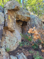
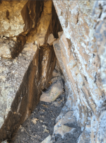
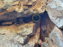
At first I didn’t notice the structure until I had passed it and glanced over my shoulder. The structure is on a downgrade on the forested north slope of the mountain I was exploring. What immediately struck me was the triangular formation of the “entrance” to the structure; it stood out as unusual.
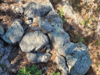
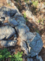
• Pic 001 and 002 is a view of the structure from the side while looking west. Taking pictures in front and from below the structure was difficult due to the slippery and steep slope in front of it. I was also worried that parts of the structure could have been rigged to collapse if it were man-made.
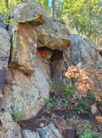
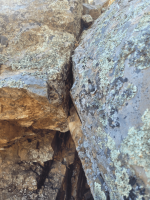
• Pic 003 shows an interesting section (yellow) that could have broken free due to weathering of the stone, although I did look for the missing piece but couldn’t find it. The red arrow indicates the viewing direction for the detail shown in Pic 008 and Pic 009.
• Pic 004 is the front of the structure taken from as far back as I could get on the slope, which was probably about 3-4 feet away from the structure.
• Pic 005 may show some sort of capstone lodged into place if this is indeed man-made, but this is purely an assumption on my part.
• Pic 006 shows the bottom of the triangular feature.
• Pic 007 shows the apex of the triangular section.
• Pic 008 is the red arrow view from Pic 003. There seem to be wedged rocks/rollers under the section highlighted in yellow Pic 003 which made me think “man-made”.
• Pic 009 and Pic 010 show additional detail of the yellow highlighted area. Has the rock eroded naturally or is that a carved horsehead? Outline provided for clarity.
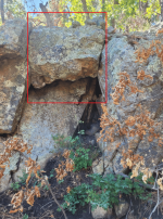
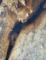
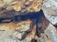
• Pic 011 is the stone “mantle” above the entrance. Entrance is on the right hand side of the picture.
• Pic 012 similar to pic 011 just a closer view.
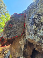
• Pic 013 view looking up at the apex
• Pic 014 red lines shows intersection between the two leaning surfaces of the apex. Yellow circle shows sunlight filtering in from the mantel.
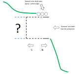
• Pic 015 Cross section view
The area above the structure was thinly forested and looked like rain and melted snow flow regularly down the slope which could have eroded away earth or additional rocks placed above the mantel. To my untrained eye, there were no other markers or pointers that would indicate a mine, cache or that something man-made was in the area. I'm not sure if this is an ancient mine entrance, cache location or natural formation, so any info or good ideas
 would be greatly appreciated. If it turns out to be nothing, so be it. The structure just adds extra spice to what was a pretty good day-long adventure!
Moderators: if this is posted in the wrong forum, please move. Thanks!
At first I didn’t notice the structure until I had passed it and glanced over my shoulder. The structure is on a downgrade on the forested north slope of the mountain I was exploring. What immediately struck me was the triangular formation of the “entrance” to the structure; it stood out as unusual.
• Pic 001 and 002 is a view of the structure from the side while looking west. Taking pictures in front and from below the structure was difficult due to the slippery and steep slope in front of it. I was also worried that parts of the structure could have been rigged to collapse if it were man-made.
• Pic 003 shows an interesting section (yellow) that could have broken free due to weathering of the stone, although I did look for the missing piece but couldn’t find it. The red arrow indicates the viewing direction for the detail shown in Pic 008 and Pic 009.
• Pic 004 is the front of the structure taken from as far back as I could get on the slope, which was probably about 3-4 feet away from the structure.
• Pic 005 may show some sort of capstone lodged into place if this is indeed man-made, but this is purely an assumption on my part.
• Pic 006 shows the bottom of the triangular feature.
• Pic 007 shows the apex of the triangular section.
• Pic 008 is the red arrow view from Pic 003. There seem to be wedged rocks/rollers under the section highlighted in yellow Pic 003 which made me think “man-made”.
• Pic 009 and Pic 010 show additional detail of the yellow highlighted area. Has the rock eroded naturally or is that a carved horsehead? Outline provided for clarity.
• Pic 011 is the stone “mantle” above the entrance. Entrance is on the right hand side of the picture.
• Pic 012 similar to pic 011 just a closer view.
• Pic 013 view looking up at the apex
• Pic 014 red lines shows intersection between the two leaning surfaces of the apex. Yellow circle shows sunlight filtering in from the mantel.
• Pic 015 Cross section view
The area above the structure was thinly forested and looked like rain and melted snow flow regularly down the slope which could have eroded away earth or additional rocks placed above the mantel. To my untrained eye, there were no other markers or pointers that would indicate a mine, cache or that something man-made was in the area. I'm not sure if this is an ancient mine entrance, cache location or natural formation, so any info or good ideas
Moderators: if this is posted in the wrong forum, please move. Thanks!
Amazon Forum Fav 👍


Attachments
-
 002 Entrance Looking West.PNG1.8 MB · Views: 99
 -
 003 Features.png1.4 MB · Views: 86
 -
 004 Front View.PNG453.8 KB · Views: 84
 -
 005 Front View Feature.PNG452.1 KB · Views: 92
 -
 006 Triangular Entrance Base.PNG424.7 KB · Views: 87
 -
 007 Triangular Entrance Apex.PNG446.5 KB · Views: 87
 -
 008 View Looking East (red arrow view).PNG419.9 KB · Views: 86
 -
 009 View Facing East.PNG403.4 KB · Views: 81
 -
 010 View Facing East Horse Head.png402.5 KB · Views: 86
 -
 011 Mantel View From Above- Wide.PNG276.4 KB · Views: 92
 -
 012 Mantel View From Above - Close Up.PNG465 KB · Views: 89
 -
 013 View Looking Up.PNG428 KB · Views: 97
 -
 014 View Looking Up Features.png428.2 KB · Views: 103
 -
 Pic 015 Cross Section Drawing.PNG8 KB · Views: 108


")