DownEast_Detecting
Sr. Member
Update at bottom in form of comment👇
had this marked as a potential site, from searching around my area on lidar. Did some more research on it last week. I also drove by to realize it was public property, so I went out there yesterday early afternoon and stayed until dark. It’s a lot bigger area than I realized. There was a dam built upstream sometime in the late 1800’s that turned most of the area into a lake. It also formed this land into a peninsula of sorts. You can see what the area looked like before the dam on the 1857 map below the red outline is where the peninsula formed. You can see the old road on lidar that is on the topo maps. The building at the end of the road is the large barn cellar hole I think.

There are 3 very distinct cellar holes here as you can see on the lidar.(red, purple & yellow circles) You can also see 2 of the buildings still standing in the 1953 aerial shot.(red & purple circles) the biggest cellar hole(red) I believe was a barn, so it is full of big iron and i had to move on. The majority of my finds were around these 3 cellar holes.

The 1900 topo shows a building at the very top of this hill.(blue circle) so I thought it would be easy to locate even without a cellar hole. I was wrong, I searched all over the top of the hill and couldn’t find anything. no iron or trash or anything. Looking at the lidar though it looks like there was some activity in the upper east area. (Green circle) To me it looks like an old road to a home site. I can’t find anything on the oldest accurate topo map of the area, 1857. So this might be an older homestead site next to the river. It would have been close to the river before the dam was built, then under. water after it was built. The dam gave way sometime in my lifetime, so the lake drained and water levels dropped. I didn’t see this on the lidar until I was home last night composing this post. So I’ll be going back there and searching that area.

These old topo maps aren’t always the most accurate. I have found buildings that should be on the 1857 map that are not. so my best guess is the 3 cellar holes are from the late 1800’s. But there could have been activity here as far back as the late 1600’s up until about 1960. So here are my finds from yesterday.

All of them together

#1 & #4 are toy axes I guess? I’m not sure how #4 attached.
#2 & #3 are buckles that i think our friend the horsey dropped

#5 a thimble?
#6 ?
?

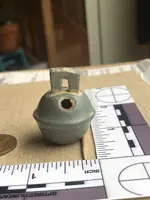
#7 is a bell but what kind? It looks more modern than most I have found.
#8 is a piece of a Crotal bell

#9 is the smallest bell I have ever found. This would be called a sleigh bell right? What is it made out of?

#10 is a suspender clip.

#11 is a baby’s ring i think. Any info on this would be appreciated. not sure if there use to be 3 stones in it?

Then various drawer pulls and a valve handle. I think I have seen #12 in some horsey stuff before as well?
had this marked as a potential site, from searching around my area on lidar. Did some more research on it last week. I also drove by to realize it was public property, so I went out there yesterday early afternoon and stayed until dark. It’s a lot bigger area than I realized. There was a dam built upstream sometime in the late 1800’s that turned most of the area into a lake. It also formed this land into a peninsula of sorts. You can see what the area looked like before the dam on the 1857 map below the red outline is where the peninsula formed. You can see the old road on lidar that is on the topo maps. The building at the end of the road is the large barn cellar hole I think.
There are 3 very distinct cellar holes here as you can see on the lidar.(red, purple & yellow circles) You can also see 2 of the buildings still standing in the 1953 aerial shot.(red & purple circles) the biggest cellar hole(red) I believe was a barn, so it is full of big iron and i had to move on. The majority of my finds were around these 3 cellar holes.
The 1900 topo shows a building at the very top of this hill.(blue circle) so I thought it would be easy to locate even without a cellar hole. I was wrong, I searched all over the top of the hill and couldn’t find anything. no iron or trash or anything. Looking at the lidar though it looks like there was some activity in the upper east area. (Green circle) To me it looks like an old road to a home site. I can’t find anything on the oldest accurate topo map of the area, 1857. So this might be an older homestead site next to the river. It would have been close to the river before the dam was built, then under. water after it was built. The dam gave way sometime in my lifetime, so the lake drained and water levels dropped. I didn’t see this on the lidar until I was home last night composing this post. So I’ll be going back there and searching that area.
These old topo maps aren’t always the most accurate. I have found buildings that should be on the 1857 map that are not. so my best guess is the 3 cellar holes are from the late 1800’s. But there could have been activity here as far back as the late 1600’s up until about 1960. So here are my finds from yesterday.
All of them together
#1 & #4 are toy axes I guess? I’m not sure how #4 attached.
#2 & #3 are buckles that i think our friend the horsey dropped
#5 a thimble?
#6
?#7 is a bell but what kind? It looks more modern than most I have found.
#8 is a piece of a Crotal bell
#9 is the smallest bell I have ever found. This would be called a sleigh bell right? What is it made out of?
#10 is a suspender clip.
#11 is a baby’s ring i think. Any info on this would be appreciated. not sure if there use to be 3 stones in it?
Then various drawer pulls and a valve handle. I think I have seen #12 in some horsey stuff before as well?
Amazon Forum Fav 👍


Attachments
Last edited:
Upvote
32
