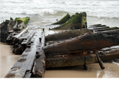
Waves reveal new wreck at Fort Morgan, Alabama

MichaelB

Sr. Member
Aug 13, 2005
463
95
Mobile Bay, Alabama
New mystery shipwreck surfaces at Fort Morgan (photos, video) | AL.com

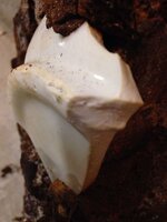
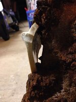
This is not the wreck that is at Cortez street that there has been so much talk about. This new one is 3 miles west of the Cortez wreck. I have documented that wreck. Look at the pictures and see what you think. A barge maybe?

At least it is something new to go check out.

Merry Christmas.

MichaelB
 

huntsman53

Gold Member
Jun 11, 2013
6,955
6,769
East Tennessee
Primary Interest:
Other
Thanks for posting the information and link to the pics! I am not an expert on ships and I definitely could be wrong but it doesn't appear to be a Barge to me. The portion with the portholes on top appear to be one side of a ship which is laying on top of the main structure. Is is possible that it was a Ferry or even Paddleboat Steamer??


Frank
 

Last edited:

bay pirate

Full Member
Aug 26, 2012
203
169
Mobile Bay
Detector(s) used
Whites MXT Pro
I looked at it yesterday. It looks like it floated in and sat down with the tides. I wish we had the water quality like BVI and St Kitts plus a third of the bull sharks
 

OP
OP
MichaelB

MichaelB

Sr. Member
Aug 13, 2005
463
95
Mobile Bay, Alabama
It is funny that you should mention a paddleboat. There are the remains of an old paddleboat 20 miles east of this position. When a big storm rolls in and you can stand in what is left of the paddle wheel in less than 20 fet of water. I wonder if something finally broke loose. Pirate you are correct, this area is bull shark heaven. It is amazing how many I see while fishing around Dixie Bar.
 

bay pirate

Full Member
Aug 26, 2012
203
169
Mobile Bay
Detector(s) used
Whites MXT Pro
I was down on Sunday with my wife and we ran into an interesting fellow. He was a wealth of knowledge and is convinced its a civil war schooner. The press is calling it a barge. His points are that there is a documented confederate schooner the got blown up 1 mile east of the fort. The soldiers abandoned ship just off the second bar, right in the nick of time before the union finished her off. We also saw two mast holes (at least 12") thru the center timbers with 5 or 6 perfect 4" holes in a line that I assume we're for the riggings. A barge would not have mast holes nor would the paddle wheeler. On a curious note, other than lining up with each other, the holes did not seem to be in the center of anything. As the timber supports were almost set at a different direction making this a much bigger vessel. I'm going back to poke around
 

Last edited:

huntsman53

Gold Member
Jun 11, 2013
6,955
6,769
East Tennessee
Primary Interest:
Other
I was down on Sunday with my wife and we ran into an interesting fellow. He was a wealth of knowledge and is convinced its a civil war schooner. The press is calling it a barge. His points are that there is a documented confederate schooner the got blown up 1 mile east of the fort. The soldiers abandoned ship just off the second bar, right in the nick of time before the union finished her off. We also saw two mast holes (at least 12") thru the center timbers with 5 or 6 perfect 4" holes in a line that I assume we're for the riggings. A barge would not have mast holes nor would the paddle wheeler. On a curious note, other than lining up with each other, the holes did not seem to be in the center of anything. As the timber supports were almost set at a different direction making this a much bigger vessel. I'm going back to poke around

You may be correct! However, a Paddlewheel Steamer would have two similar sized holes for the smoke stacks. Are the two holes lined up linear (Bow and Stern) or are they lined up width-wise (Port and Starboard)? If it is the latter, then more than likely, it was a Paddlewheel Steamer Boat!


Frank
 

Last edited:

Jolly Mon

Hero Member
Sep 3, 2012
868
631
Primary Interest:
All Treasure Hunting
I think E. Lee Spence's comments in the story link are interesting.
 

Jolly Mon

Hero Member
Sep 3, 2012
868
631
Primary Interest:
All Treasure Hunting
I was down on Sunday with my wife and we ran into an interesting fellow. He was a wealth of knowledge and is convinced its a civil war schooner. The press is calling it a barge. His points are that there is a documented confederate schooner the got blown up 1 mile east of the fort. The soldiers abandoned ship just off the second bar, right in the nick of time before the union finished her off. We also saw two mast holes (at least 12") thru the center timbers with 5 or 6 perfect 4" holes in a line that I assume we're for the riggings. A barge would not have mast holes nor would the paddle wheeler. On a curious note, other than lining up with each other, the holes did not seem to be in the center of anything. As the timber supports were almost set at a different direction making this a much bigger vessel. I'm going back to poke around

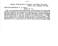
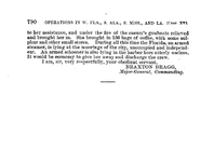
I am not sure if this is the gentleman you spoke with, but here is a link to a new story on the wreck from the Gulf Shores Islander from Jan 5th. UPDATED WITH NEW PHOTOS: Author identifies Fort Morgan shipwreck as Civil War schooner - GulfCoastNewsToday.com: Local News The gist of the story is that a local author believes the wreck is that of a Confederate schooner run ashore near Ft. Morgan on Dec 27th, 1861.

I am a little mystified by this, unless there were two ships run ashore on the 27th, 1861 or this letter from Braxton Bragg is completely mistaken (which, of course, is possible).

fort morgan shipwreck, 1.png fort morgan shipwreck, 2.png ORUCN, Series 1, vol. 6
 

Jolly Mon

Hero Member
Sep 3, 2012
868
631
Primary Interest:
All Treasure Hunting
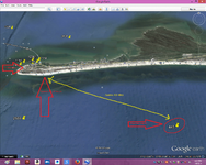
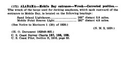
I am just throwing this out there, and I am certainly no expert, but I was struck from the beginning at what appear to be ship ribs above what looks like the flat bottom of a barge type vessel. And yet, the ribs do not seem wide enough for a vessel of such stout construction. And they are above what looks like the flat bottom of a barge. Anyway, here is a possibility for consideration.

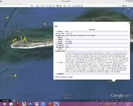
fort morgan shipwreck, 3.png BARGE; POSITION ACCURACY WITHIN 1 MILE; LOCATED 1/17/20 (SOURCE ì UNK.); REPORTED THROUGH H.O. FILES, DATED 7/16/43 27 NO.614; SUNK BEFORE WWII; BARGE USED FOR DECKING SEAPLANES; 265 DEG. ì 5.8 MILES FROM SAND ISLAND LIGHTHOUSE, 292 DEG. 4.8 MILES FROM MOBILE ì BEACON LIGHT. H9452/74WD-CANCELED 4/29/86; NEW REGISTRY NUMBER: FE276/74WD SURVEY REQUIREMENTS INFORMATION ASSIGNED: OPR-J217-MI-85 ( From NOAA, Wrecks and Obstructions data).
fort morgan shipwreck, 4.png
fort morgan shipwreck, 5.png
fort morgan shipwreck, 6.png From Notice to Mariners, 1920

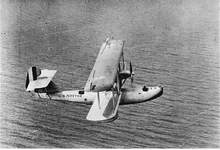
I can imagine the fuselage of a WW I era seaplane slipping into this quite nicely.

Boeing PB 1.png
 

Last edited:

bay pirate

Full Member
Aug 26, 2012
203
169
Mobile Bay
Detector(s) used
Whites MXT Pro
I also met a couple of snow birds that own property and come down every year. This was their first time on the beach this year and said that they saw, last year, the very tip of one of the northern beams sticking out of the sand. It was only a couple of inches visible. This would let me believe that the wreck has been in this very spot for years. Each time the tide comes in and out, more and more feature appear and it looks deeper than first thought. As far as the ribs, they show evidence of fire and explosion damage which makes me believe the schooner version
 

Jolly Mon

Hero Member
Sep 3, 2012
868
631
Primary Interest:
All Treasure Hunting
I also met a couple of snow birds that own property and come down every year. This was their first time on the beach this year and said that they saw, last year, the very tip of one of the northern beams sticking out of the sand. It was only a couple of inches visible. This would let me believe that the wreck has been in this very spot for years. Each time the tide comes in and out, more and more feature appear and it looks deeper than first thought. As far as the ribs, they show evidence of fire and explosion damage which makes me believe the schooner version

I am not sure if you are familiar with Dr. E. Lee Spence, but he is a marine archaeologist with some formidable experience. He was the original discoverer of CSS Hunley. He posted some questions this morning on the Gulf Shores Islander website concerning the wreck (the link to this publication is in one of my previous posts). The questions he has require local knowledge I am unable to provide. Perhaps someone here can provide him with answers. They might help to shed some light on this situation.

As far as this being a Civil War era wreck, it is, IMHO, entirely possible. A quick glance through the Official Records gives several different possibilities.
As for explosion and fire damage to the ribs, something caused the seaplane barge to sink as well. It is easy for me to imagine a fire breaking out on a seaplane barge---perhaps a barge with airplane fuel aboard.
 

Last edited:

bay pirate

Full Member
Aug 26, 2012
203
169
Mobile Bay
Detector(s) used
Whites MXT Pro
Pirate I am going to head down there this weekend. Exactly where is it so I know where to park and hike? Thanks. Michael
All the way down fort Morgan road to mile marker 1. There is a street on the left, the only street, and it's been washed out with only a little blacktop left. It's about 100 yards west in the shoreline. I'm taking my girls to see it also. PM your phone number and let's go together.
 

bay pirate

Full Member
Aug 26, 2012
203
169
Mobile Bay
Detector(s) used
Whites MXT Pro
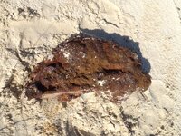
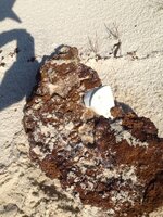
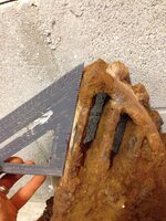
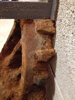
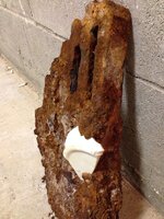
Found this today about a 1/4 mile west of the wreck. It looks like it used to be a solid circle but it's since been broken in half. Maybe it's a man hole cover but what are the curious knobs on the the outer band not to mention the porcelain plate encrusted in it.

image-2145227129.jpg


image-2175989901.jpg


image-9635786.jpg


image-2164901446.jpg


image-1467417795.jpg


image-3034890673.jpg


image-1972317471.jpg
 

Jolly Mon

Hero Member
Sep 3, 2012
868
631
Primary Interest:
All Treasure Hunting
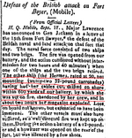
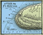
Here is another possibility....

hermes fort boyer.png Columbian Centinel, Oct. 22nd, 1814

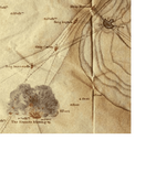
hermes blowing up cut.png


There ought to be 22 or so large pieces of iron somewhere in the vicinity...
I don't know much about the erosion/ accretion cycle on the Fort Morgan peninsula, but it is possible the wreck might be in very shallow water...maybe even under the present beach.
Comparing the chart from 1814 with those from 1856 and the present day, it appears Mobile Point built out substantially, though it may be receding today.
 

RELICDUDE07

Bronze Member
Oct 2, 2007
2,128
54
Pascagoula Ms.
Detector(s) used
minelab exp.
THE GULF COAST I ALABAMA: 363. Year 1814. English warship H.M.S. Hermes, 2o guns, Captain William Henry Percy, was sunk while attacking the batterie d6adfa3ba63aaa0098a3594238f4e4eb.jpg
 

Top Member Reactions

Users who are viewing this thread

Top